

<< Our Photo Pages >> Barnagowlane West wedge tomb - Wedge Tomb in Ireland (Republic of) in Co. Cork
Submitted by GaelicLaird on Thursday, 01 February 2024 Page Views: 95
Neolithic and Bronze AgeSite Name: Barnagowlane West wedge tombCountry: Ireland (Republic of) County: Co. Cork Type: Wedge Tomb
Nearest Village: Kealkill
Latitude: 51.725966N Longitude: 9.306262W
Condition:
| 5 | Perfect |
| 4 | Almost Perfect |
| 3 | Reasonable but with some damage |
| 2 | Ruined but still recognisable as an ancient site |
| 1 | Pretty much destroyed, possibly visible as crop marks |
| 0 | No data. |
| -1 | Completely destroyed |
| 5 | Superb |
| 4 | Good |
| 3 | Ordinary |
| 2 | Not Good |
| 1 | Awful |
| 0 | No data. |
| 5 | Can be driven to, probably with disabled access |
| 4 | Short walk on a footpath |
| 3 | Requiring a bit more of a walk |
| 2 | A long walk |
| 1 | In the middle of nowhere, a nightmare to find |
| 0 | No data. |
| 5 | co-ordinates taken by GPS or official recorded co-ordinates |
| 4 | co-ordinates scaled from a detailed map |
| 3 | co-ordinates scaled from a bad map |
| 2 | co-ordinates of the nearest village |
| 1 | co-ordinates of the nearest town |
| 0 | no data |
Internal Links:
External Links:
")
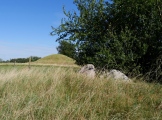
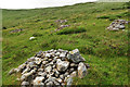
On low rise in valley bottom about 100m S of Mealagh river. Wedge-shaped gallery (L 2.8m; Wth 1.2m at W end, 0.8m at E) open to SW, represented by two orthostats and fallen sidestone to N, backstone to E; covered by a single roofstone. Three outer-wall stones visible at E end gallery. Remains of mound survive to N and W of monument. (Ó Nualláin 1989, 135).
Myler (1998, 83) records that 'this area has recently been planted with trees and new forestry drains run to within a couple of yards of the tomb. The stones appear to be undamaged but it is in a heavily overgrown state.'
The above description is derived from the published 'Archaeological Inventory of County Cork. Volume 1: West Cork' (Dublin: Stationery Office, 1992).
This wedge tomb is indicated on 1902 Ordnance Survey map as Knockanenaolora, an anglicisation of either Cnocán an Altórach (the hillock of the altar), or Chocán a'Nealora ('hillock of the look-out man').
In the bog to the west of this tomb hüman remains were found and reported to the Royal Irish Constabulary sometime around 1912. The body was found in a turf bank and was dressed in a uniform with buckled shoes. It was later re-interred under a flagstone some distance west of the wedge tomb. There is speculation that this may have been the remains of an informer who came to the area in Fenian times (around 1867), but the identity of this unfortunate person will remain a mystery.
In the boggy hollow just south of the wedge tomb a bed of wattles was previously exposed on a bank of turf. It was 2 feet from the surface and showed up white against the black turf. This feature was believed to have been part of a pathway which once led across the boggy ground.
Text courtesy of David Myler.
You may be viewing yesterday's version of this page. To see the most up to date information please register for a free account.
")
")
")
Do not use the above information on other web sites or publications without permission of the contributor.
Nearby Images from Geograph Britain and Ireland:
©2013(licence)
©2013(licence)
©2011(licence)
©2015(licence)
©2013(licence)
The above images may not be of the site on this page, they are loaded from Geograph.
Please Submit an Image of this site or go out and take one for us!
Click here to see more info for this site
Nearby sites
Click here to view sites on an interactive map of the areaKey: Red: member's photo, Blue: 3rd party photo, Yellow: other image, Green: no photo - please go there and take one, Grey: site destroyed
Download sites to:
KML (Google Earth)
GPX (GPS waypoints)
CSV (Garmin/Navman)
CSV (Excel)
To unlock full downloads you need to sign up as a Contributory Member. Otherwise downloads are limited to 50 sites.
Turn off the page maps and other distractions
Nearby sites listing. In the following links * = Image available
322m NE 39° Coomleagh East* Stone Row / Alignment (W10005361)
1.4km E 82° CoomleaghEast standing stone* Standing Stone (Menhir)
1.4km ENE 77° An Com Liath Thoir standing stone* Standing Stone (Menhir)
1.4km NW 314° Gortnacowly four poster* Standing Stones
1.8km E 80° EastCoomleagh standing stone* Standing Stone (Menhir)
2.0km NW 313° Ardrah wedge tomb* Wedge Tomb
2.2km E 82° Coom Leagh East Stone Row* Stone Row / Alignment
2.8km NNW 328° Maughanaclea* Stone Circle (W08355580)
2.9km NNW 330° Maughanaclea Centre* Stone Circle (W08385588)
2.9km WNW 292° Ardrah Stone Row* Stone Row / Alignment (W0710854517)
3.1km NNW 343° Maughanclea SW* Stone Circle (W08945630)
3.2km N 10° Maughanclea NE* Stone Circle (W104565)
3.4km SW 215° Coomanore South* Standing Stones
3.6km NNE 22° Cousane* Stone Circle (W11205670)
4.1km NNW 337° Cahermuckee* Standing Stones (W08245714)
4.4km NE 38° An Cuasán standing stone* Standing Stone (Menhir)
4.5km W 274° Derryarkane Stone Circle (W05255374)
4.9km WNW 296° Kealkil* Stone Circle (W0538155588)
5.1km WNW 291° Breeney More* Stone Circle (W05085526)
5.4km SE 131° Leitry Lower* Stone Row / Alignment (W13804971)
5.4km ESE 104° Cullenagh Standing Stones* Standing Stones (W1503551946)
5.7km E 101° Cullenagh Stone Row* Stone Row / Alignment (W15365220)
5.9km SE 139° Ceancullig Standing Stones (W13594886)
6.0km NNE 13° Gortloughra Standing Stones (W11235924)
6.3km E 96° Cullenagh Pair Standing Stones (W16035264)
View more nearby sites and additional images


 We would like to know more about this location. Please feel free to add a brief description and any relevant information in your own language.
 Wir möchten mehr über diese Stätte erfahren. Bitte zögern Sie nicht, eine kurze Beschreibung und relevante Informationen in Deutsch hinzuzufügen.
 Nous aimerions en savoir encore un peu sur les lieux. S'il vous plaît n'hesitez pas à ajouter une courte description et tous les renseignements pertinents dans votre propre langue.
 Quisieramos informarnos un poco más de las lugares. No dude en añadir una breve descripción y otros datos relevantes en su propio idioma.