 with our Megalithic Portal iPhone app")

<< Our Photo Pages >> Menhir Marie d'Évron - Standing Stone (Menhir) in France in Pays de la Loire:Mayenne (53)
Submitted by foz750 on Tuesday, 25 July 2023 Page Views: 152
Neolithic and Bronze AgeSite Name: Menhir Marie d'ÉvronCountry: France Département: Pays de la Loire:Mayenne (53) Type: Standing Stone (Menhir)
Nearest Town: Évron
Latitude: 48.156452N Longitude: 0.400643W
Condition:
| 5 | Perfect |
| 4 | Almost Perfect |
| 3 | Reasonable but with some damage |
| 2 | Ruined but still recognisable as an ancient site |
| 1 | Pretty much destroyed, possibly visible as crop marks |
| 0 | No data. |
| -1 | Completely destroyed |
| 5 | Superb |
| 4 | Good |
| 3 | Ordinary |
| 2 | Not Good |
| 1 | Awful |
| 0 | No data. |
| 5 | Can be driven to, probably with disabled access |
| 4 | Short walk on a footpath |
| 3 | Requiring a bit more of a walk |
| 2 | A long walk |
| 1 | In the middle of nowhere, a nightmare to find |
| 0 | No data. |
| 5 | co-ordinates taken by GPS or official recorded co-ordinates |
| 4 | co-ordinates scaled from a detailed map |
| 3 | co-ordinates scaled from a bad map |
| 2 | co-ordinates of the nearest village |
| 1 | co-ordinates of the nearest town |
| 0 | no data |
Internal Links:
External Links:
")
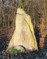
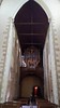
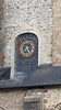
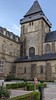
Situated outside the Marie d'Évron near the main entrance on the left is a single menhir 1.5mts approx, in a flower bed.
One would imagine that due to the modern building and placement of stone that it is not in original position.
You may be viewing yesterday's version of this page. To see the most up to date information please register for a free account.
")
")
Do not use the above information on other web sites or publications without permission of the contributor.
Nearby Images from Flickr
The above images may not be of the site on this page, but were taken nearby. They are loaded from Flickr so please click on them for image credits.
Click here to see more info for this site
Nearby sites
Click here to view sites on an interactive map of the areaKey: Red: member's photo, Blue: 3rd party photo, Yellow: other image, Green: no photo - please go there and take one, Grey: site destroyed
Download sites to:
KML (Google Earth)
GPX (GPS waypoints)
CSV (Garmin/Navman)
CSV (Excel)
To unlock full downloads you need to sign up as a Contributory Member. Otherwise downloads are limited to 50 sites.
Turn off the page maps and other distractions
Nearby sites listing. In the following links * = Image available
183m W 265° Menhir Basilique Notre Dame de L'épine* Standing Stone (Menhir)
5.7km NE 41° La Chaise du Diable* Natural Stone / Erratic / Other Natural Feature
5.8km N 358° Dolmen des Pierres Jumelles* Burial Chamber or Dolmen
5.8km N 354° Pierre Aigue, Richebourg* Passage Grave
5.9km ENE 58° Dolmen de la Pierre au Renard Burial Chamber or Dolmen
6.1km NE 40° Pierres dit Palais du Diable* Natural Stone / Erratic / Other Natural Feature
6.8km SE 131° Dolmen des Erves* Burial Chamber or Dolmen
7.1km NNE 22° Fort de Rubricaire* Ancient Village or Settlement
7.1km SE 128° Dolmen des Iles* Burial Chamber or Dolmen
8.8km NE 47° La Fosses* Standing Stones
9.2km ESE 112° Stele des Trois Poiriers* Sculptured Stone
10.7km NE 51° La Championnière* Standing Stone (Menhir)
10.8km SE 138° La Table des Diables* Burial Chamber or Dolmen
12.0km NNE 31° Menhir du Gué Blandin* Standing Stone (Menhir)
13.0km NE 38° Menhir du Gué Péan Standing Stone (Menhir)
13.0km NNW 326° Camp Romain de Jublains* Ancient Village or Settlement
13.1km NNW 328° Jublains Stèle Gauloise* Standing Stone (Menhir)
13.1km NNW 327° Jublains museum stone* Standing Stone (Menhir)
13.1km NE 38° Pierre Longue de Lèverie Standing Stone (Menhir)
13.2km NNW 327° Les Fouées* Standing Stone (Menhir)
14.4km NE 56° La Chapelle du Chene* Modern Stone Circle etc
14.4km NE 56° La Croix de la Motte* Ancient Cross
14.7km NE 49° La Brillandière* Marker Stone
14.7km NE 51° La Brosse* Standing Stone (Menhir)
14.9km NE 39° Bonnes Dames Allée couverte Passage Grave
View more nearby sites and additional images


 We would like to know more about this location. Please feel free to add a brief description and any relevant information in your own language.
 Wir möchten mehr über diese Stätte erfahren. Bitte zögern Sie nicht, eine kurze Beschreibung und relevante Informationen in Deutsch hinzuzufügen.
 Nous aimerions en savoir encore un peu sur les lieux. S'il vous plaît n'hesitez pas à ajouter une courte description et tous les renseignements pertinents dans votre propre langue.
 Quisieramos informarnos un poco más de las lugares. No dude en añadir una breve descripción y otros datos relevantes en su propio idioma.