

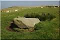
<< Our Photo Pages >> Rhiwgaregog Standing Stone (recumbent) - Standing Stone (Menhir) in Wales in Ceredigion
Submitted by geoffstickland on Thursday, 16 February 2023 Page Views: 1279
Neolithic and Bronze AgeSite Name: Rhiwgaregog Standing Stone (recumbent) Alternative Name: we are not sure that other authorities use this nameCountry: Wales County: Ceredigion Type: Standing Stone (Menhir)
Nearest Town: Lampeter Nearest Village: Cwrt y Cadno
Map Ref: SN71274364
Latitude: 52.076113N Longitude: 3.879776W
Condition:
| 5 | Perfect |
| 4 | Almost Perfect |
| 3 | Reasonable but with some damage |
| 2 | Ruined but still recognisable as an ancient site |
| 1 | Pretty much destroyed, possibly visible as crop marks |
| 0 | No data. |
| -1 | Completely destroyed |
| 5 | Superb |
| 4 | Good |
| 3 | Ordinary |
| 2 | Not Good |
| 1 | Awful |
| 0 | No data. |
| 5 | Can be driven to, probably with disabled access |
| 4 | Short walk on a footpath |
| 3 | Requiring a bit more of a walk |
| 2 | A long walk |
| 1 | In the middle of nowhere, a nightmare to find |
| 0 | No data. |
| 5 | co-ordinates taken by GPS or official recorded co-ordinates |
| 4 | co-ordinates scaled from a detailed map |
| 3 | co-ordinates scaled from a bad map |
| 2 | co-ordinates of the nearest village |
| 1 | co-ordinates of the nearest town |
| 0 | no data |
Internal Links:
External Links:
 (PID:254401)")
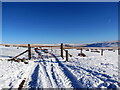
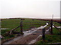
A Bronze Age recumbent standing stone set on the Western slopes of Mynydd Maellaen on a grassy, S facing slope. A partly buried stone 5' long and 20' at its widest point. Immediatly beside the ancient track way.
You may be viewing yesterday's version of this page. To see the most up to date information please register for a free account.
Do not use the above information on other web sites or publications without permission of the contributor.
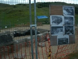
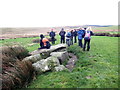
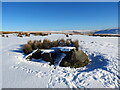
Nearby Images from Geograph Britain and Ireland:
©2017(licence)
©2023(licence)
©2008(licence)
©2023(licence)
©2014(licence)
The above images may not be of the site on this page, they are loaded from Geograph.
Please Submit an Image of this site or go out and take one for us!
Click here to see more info for this site
Nearby sites
Key: Red: member's photo, Blue: 3rd party photo, Yellow: other image, Green: no photo - please go there and take one, Grey: site destroyed
Download sites to:
KML (Google Earth)
GPX (GPS waypoints)
CSV (Garmin/Navman)
CSV (Excel)
To unlock full downloads you need to sign up as a Contributory Member. Otherwise downloads are limited to 50 sites.
Turn off the page maps and other distractions
Nearby sites listing. In the following links * = Image available
134m SW 220° Rhiw Gwaregog Standing Stone Standing Stone (Menhir) (SN71184354)
150m SW 215° Rhiw Garegog Ditch* Misc. Earthwork (SN71184352)
150m S 182° Rhiw Garegog Standing Stone II* Standing Stone (Menhir) (SN71264349)
190m SSW 197° Rhiw Garegog Round barrows* Round Barrow(s) (SN71214346)
456m SSE 153° Rhiw Garegog Scoop Grave 2 Misc. Earthwork (SN71474323)
519m SSE 163° Rhiw Garegog Scoop Grave 1 Misc. Earthwork (SN71414314)
1.8km WSW 247° Maes-yr-haidd Round Barrow I* Cairn (SN6960042991)
1.9km WSW 245° Maes-yr-haidd Round Barrow II* Cairn (SN6954242882)
2.1km NNE 25° Crugiau Merched, Cairn 1* Cairn (SN72214553)
2.2km NNE 26° Crugiau Merched* Cairn (SN72274555)
2.2km NNE 27° Crugiau Merched Cairn 2 Cairn (SN72324557)
2.3km NE 50° Maen Bach* Standing Stone (Menhir) (SN73084507)
2.5km ENE 63° Mynydd Mallaen* Standing Stone (Menhir) (SN73564471)
4.2km S 182° Nant-Iwrch Cairn* Ring Cairn (SN71043946)
4.5km NNE 15° Esgair Nant-y-Maen cairn* Ring Cairn (SN72544798)
4.8km NNW 343° Crug Siarls* Stone Circle (SN69954830)
5.6km NE 48° Cefn Gwenffrwd Maenhir* Standing Stone (Menhir) (SN75514725)
5.6km NE 52° Randirmwyn Standing Stone* Standing Stone (Menhir) (SN758470)
5.9km SW 235° Carreg Pumsaint* Standing Stone (Menhir) (SN66334035)
5.9km SW 234° Dolaucothi* Ancient Mine, Quarry or other Industry (SN66384025)
6.0km S 175° Berrisbrook Standing Stones* Standing Stone (Menhir) (SN71603761)
6.2km ENE 68° Gelli Burial Chamber* Chambered Cairn (SN7703845843)
6.2km NNE 22° Cefn Gwernffrwd stone circle* Stone Circle (SN7370049328)
6.2km NNE 22° Cefn Gwernffrwd Row* Stone Row / Alignment (SN7370049328)
6.4km E 93° Dinas Bach (Cilycwm)* Hillfort (SN77704310)
View more nearby sites and additional images


 We would like to know more about this location. Please feel free to add a brief description and any relevant information in your own language.
 Wir möchten mehr über diese Stätte erfahren. Bitte zögern Sie nicht, eine kurze Beschreibung und relevante Informationen in Deutsch hinzuzufügen.
 Nous aimerions en savoir encore un peu sur les lieux. S'il vous plaît n'hesitez pas à ajouter une courte description et tous les renseignements pertinents dans votre propre langue.
 Quisieramos informarnos un poco más de las lugares. No dude en añadir una breve descripción y otros datos relevantes en su propio idioma.