

<< Our Photo Pages >> Revhaugen (Vestby) - Round Barrow(s) in Norway in Akershus
Submitted by kenntha88 on Thursday, 06 October 2022 Page Views: 312
Neolithic and Bronze AgeSite Name: Revhaugen (Vestby)Country: Norway Fylke: Akershus Type: Round Barrow(s)
Nearest Village: Vestby
Latitude: 59.600002N Longitude: 10.730196E
Condition:
| 5 | Perfect |
| 4 | Almost Perfect |
| 3 | Reasonable but with some damage |
| 2 | Ruined but still recognisable as an ancient site |
| 1 | Pretty much destroyed, possibly visible as crop marks |
| 0 | No data. |
| -1 | Completely destroyed |
| 5 | Superb |
| 4 | Good |
| 3 | Ordinary |
| 2 | Not Good |
| 1 | Awful |
| 0 | No data. |
| 5 | Can be driven to, probably with disabled access |
| 4 | Short walk on a footpath |
| 3 | Requiring a bit more of a walk |
| 2 | A long walk |
| 1 | In the middle of nowhere, a nightmare to find |
| 0 | No data. |
| 5 | co-ordinates taken by GPS or official recorded co-ordinates |
| 4 | co-ordinates scaled from a detailed map |
| 3 | co-ordinates scaled from a bad map |
| 2 | co-ordinates of the nearest village |
| 1 | co-ordinates of the nearest town |
| 0 | no data |
Internal Links:
External Links:
 (PID:248982)")
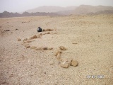
The site consists of two large round barrows. The largest is called "Revhaugen". It is inside a tight forest surrounded by flat fields. The barrow is overgrown with large trees and can be difficult to make out from the road. It is 18 metres in diameter and 2,5 metres in height.
The other barrow is a part of a private yard. It is around 100 metres west of the Revhaugen barrow. It is covered only with short grass and one giant old oak tree. Right south of the barrow is a red garage building. The barrow is 19 metres in diameter and 3 metres in height. It has a beautiful shape and doesnt seem to be having any damage.
You may be viewing yesterday's version of this page. To see the most up to date information please register for a free account.
 (PID:248985)")
 (PID:248984)")
 (PID:248983)")
Do not use the above information on other web sites or publications without permission of the contributor.
Nearby Images from Flickr


The above images may not be of the site on this page, but were taken nearby. They are loaded from Flickr so please click on them for image credits.
Click here to see more info for this site
Nearby sites
Click here to view sites on an interactive map of the areaKey: Red: member's photo, Blue: 3rd party photo, Yellow: other image, Green: no photo - please go there and take one, Grey: site destroyed
Download sites to:
KML (Google Earth)
GPX (GPS waypoints)
CSV (Garmin/Navman)
CSV (Excel)
To unlock full downloads you need to sign up as a Contributory Member. Otherwise downloads are limited to 50 sites.
Turn off the page maps and other distractions
Nearby sites listing. In the following links * = Image available
3.9km SW 220° Hauger-Torp* Stone Circle
4.2km SW 215° Nubsrud* Cairn
5.2km ESE 117° Enerås-Hovum* Barrow Cemetery
5.2km ESE 111° Nordre-Hovum/Hovtun* Barrow Cemetery
5.5km ESE 115° Garder* Barrow Cemetery
5.5km NE 35° Vardåsen* Hillfort
6.4km NNW 346° Rishaugen* Round Barrow(s)
6.5km N 354° Vestre Holstad* Round Barrow(s)
6.6km N 359° Haug Vestre* Round Barrow(s)
8.8km NNE 18° Østby-Kongeveien* Barrow Cemetery
9.1km N 8° Kinnsås* Hillfort
10.2km NNE 29° Skuterudsletta* Barrow Cemetery
11.0km NE 38° Bernhus* Stone Circle
11.1km NE 45° Tomter* Stone Circle
11.7km NE 43° Prestegårdshavna* Barrow Cemetery
12.0km NE 45° Kråkstad* Barrow Cemetery
13.8km NE 42° St Hanshaugen* Round Barrow(s)
13.9km N 10° Nordby-Østre* Barrow Cemetery
14.0km ESE 121° Bjørnefestningen* Hillfort
14.5km NE 40° Mellegård* Barrow Cemetery
14.7km W 259° Holtvedtryggen* Stone Circle
15.5km NNE 25° Vardehaug* Barrow Cemetery
16.2km SSE 165° Bergeråsen* Hillfort
18.9km E 79° Hylligraven* Passage Grave
19.1km WSW 249° Røysene Cairns* Clava Cairn
View more nearby sites and additional images


 We would like to know more about this location. Please feel free to add a brief description and any relevant information in your own language.
 Wir möchten mehr über diese Stätte erfahren. Bitte zögern Sie nicht, eine kurze Beschreibung und relevante Informationen in Deutsch hinzuzufügen.
 Nous aimerions en savoir encore un peu sur les lieux. S'il vous plaît n'hesitez pas à ajouter une courte description et tous les renseignements pertinents dans votre propre langue.
 Quisieramos informarnos un poco más de las lugares. No dude en añadir una breve descripción y otros datos relevantes en su propio idioma.