


<< Our Photo Pages >> Offerton Moor West - Ring Cairn in England in Derbyshire
Submitted by aknifethatfellfromth on Monday, 12 September 2022 Page Views: 443
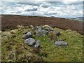
Neolithic and Bronze AgeSite Name: Offerton Moor WestCountry: England County: Derbyshire Type: Ring Cairn
Nearest Town: Hathersage Nearest Village: Hathersage
Map Ref: SK2115580550
Latitude: 53.321457N Longitude: 1.68388W
Condition:
| 5 | Perfect |
| 4 | Almost Perfect |
| 3 | Reasonable but with some damage |
| 2 | Ruined but still recognisable as an ancient site |
| 1 | Pretty much destroyed, possibly visible as crop marks |
| 0 | No data. |
| -1 | Completely destroyed |
| 5 | Superb |
| 4 | Good |
| 3 | Ordinary |
| 2 | Not Good |
| 1 | Awful |
| 0 | No data. |
| 5 | Can be driven to, probably with disabled access |
| 4 | Short walk on a footpath |
| 3 | Requiring a bit more of a walk |
| 2 | A long walk |
| 1 | In the middle of nowhere, a nightmare to find |
| 0 | No data. |
| 5 | co-ordinates taken by GPS or official recorded co-ordinates |
| 4 | co-ordinates scaled from a detailed map |
| 3 | co-ordinates scaled from a bad map |
| 2 | co-ordinates of the nearest village |
| 1 | co-ordinates of the nearest town |
| 0 | no data |
Internal Links:
External Links:
")
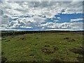
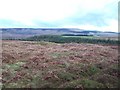
Located on open moorland a 10 minute walk East, from the path that traverses Abney/Offerton Moors.
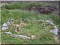
A large, tidy ring cairn, with an entrance to the SE. A few metres beyond is the smaller, damaged ring cairn of Offerton Moor East Ring Cairn.
Note: this site is scheduled as Historic England List ID 1016627, "Cairnfield and ring cairn 490m south of Offerton Hall". The Historic England map search also brings up a number of other tumuli and a named cairn (the Reform Stone) - see HE list ID 1016626, HE list ID 1016625, HE List ID 1016624 and HE List ID 1016628
You may be viewing yesterday's version of this page. To see the most up to date information please register for a free account.
")
")
Do not use the above information on other web sites or publications without permission of the contributor.
Nearby Images from Geograph Britain and Ireland:
©2021(licence)
©2010(licence)
©2011(licence)
©2011(licence)
©2021(licence)
The above images may not be of the site on this page, they are loaded from Geograph.
Please Submit an Image of this site or go out and take one for us!
Click here to see more info for this site
Nearby sites
Key: Red: member's photo, Blue: 3rd party photo, Yellow: other image, Green: no photo - please go there and take one, Grey: site destroyed
Download sites to:
KML (Google Earth)
GPX (GPS waypoints)
CSV (Garmin/Navman)
CSV (Excel)
To unlock full downloads you need to sign up as a Contributory Member. Otherwise downloads are limited to 50 sites.
Turn off the page maps and other distractions
Nearby sites listing. In the following links * = Image available
153m ESE 109° Offerton Moor East* Stone Circle (SK213805)
566m SE 143° Highlow Bank* Standing Stone (Menhir) (SK215801)
866m W 260° Smelting Hill* Stone Circle (SK203804)
984m WSW 256° Abney Moor I* Stone Circle (SK202803)
1.8km W 272° Burton Bole* Round Barrow(s) (SK194806)
1.9km S 170° Stanage* Cairn (SK215787)
2.0km ENE 62° Healing Spring* Holy Well or Sacred Spring (SK229815)
2.1km SE 139° Eyam Moor Barrow* Long Barrow (SK22547900)
2.1km SE 138° Wet Withens* Stone Circle (SK22557900)
2.5km SSW 195° Derwic Well* Holy Well or Sacred Spring (SK2054978171)
2.6km SE 127° Eyam Moor II* Stone Circle (SK232790)
2.7km SE 131° Eyam Moor III* Stone Circle (SK232788)
3.0km WNW 283° The Grey Ditch* Misc. Earthwork (SK182812)
3.5km WSW 240° Crow Chin cairns* Cairn (SK1815578818)
3.5km SSE 163° Mompesson's Well* Holy Well or Sacred Spring (SK222772)
3.6km NE 38° Trinity Well (Hathersage)* Holy Well or Sacred Spring (SK234834)
3.8km S 174° Eyam Museum* Museum (SK2159176729)
3.9km NE 36° North Lees Romano British Village* Ancient Village or Settlement (SK2343083673)
3.9km W 267° Hazlebadge Round Barrow 1* Round Barrow(s) (SK17268034)
3.9km NNE 25° Dennis Knoll* Cairn (SK228841)
3.9km W 261° Hazlebadge Round Barrow 2* Round Barrow(s) (SK17257991)
4.0km SW 234° Burr Tor* Hillfort (SK179782)
4.0km WNW 291° Bath Spring Holy Well or Sacred Spring (SK174820)
4.0km SSE 159° Top Of Riley Stone Circle (SK226768)
4.1km NNE 27° Sheepwash Bank Cairn (SK230842)
View more nearby sites and additional images


 We would like to know more about this location. Please feel free to add a brief description and any relevant information in your own language.
 Wir möchten mehr über diese Stätte erfahren. Bitte zögern Sie nicht, eine kurze Beschreibung und relevante Informationen in Deutsch hinzuzufügen.
 Nous aimerions en savoir encore un peu sur les lieux. S'il vous plaît n'hesitez pas à ajouter une courte description et tous les renseignements pertinents dans votre propre langue.
 Quisieramos informarnos un poco más de las lugares. No dude en añadir una breve descripción y otros datos relevantes en su propio idioma.