 with our Megalithic Portal iPhone app")


<< Our Photo Pages >> Stumpy Cross - Ancient Cross in England in Cornwall
Submitted by lucasn on Wednesday, 28 October 2020 Page Views: 689
Early Medieval (Dark Age)Site Name: Stumpy Cross Alternative Name: Stump CrossCountry: England County: Cornwall Type: Ancient Cross
Nearest Town: Torpoint Nearest Village: Sheviock
Map Ref: SX36285504
Latitude: 50.372419N Longitude: 4.303686W
Condition:
| 5 | Perfect |
| 4 | Almost Perfect |
| 3 | Reasonable but with some damage |
| 2 | Ruined but still recognisable as an ancient site |
| 1 | Pretty much destroyed, possibly visible as crop marks |
| 0 | No data. |
| -1 | Completely destroyed |
| 5 | Superb |
| 4 | Good |
| 3 | Ordinary |
| 2 | Not Good |
| 1 | Awful |
| 0 | No data. |
| 5 | Can be driven to, probably with disabled access |
| 4 | Short walk on a footpath |
| 3 | Requiring a bit more of a walk |
| 2 | A long walk |
| 1 | In the middle of nowhere, a nightmare to find |
| 0 | No data. |
| 5 | co-ordinates taken by GPS or official recorded co-ordinates |
| 4 | co-ordinates scaled from a detailed map |
| 3 | co-ordinates scaled from a bad map |
| 2 | co-ordinates of the nearest village |
| 1 | co-ordinates of the nearest town |
| 0 | no data |
Internal Links:
External Links:
")
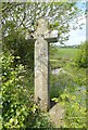
Stumpy Cross, also known as Stump Cross, stands slightly set back on a hedge at a crossroads in Sheviock parish, at the top of the Rame Peninsula in South-East Cornwall. It stands at 7.5 feet (2.3 metres) high and is 2.5 feet (0.75 metres) wide across the arms. The cross originally stood closer to the road, however was moved to its present position during road widening in 1943. It is believed that the cross may have marked the route to St Germans Priory.
You may be viewing yesterday's version of this page. To see the most up to date information please register for a free account.
")
")
")
Do not use the above information on other web sites or publications without permission of the contributor.
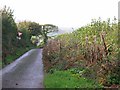
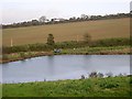
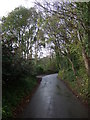
Nearby Images from Geograph Britain and Ireland:
©2019(licence)
©2007(licence)
©2007(licence)

©2014(licence)
©2014(licence)
The above images may not be of the site on this page, they are loaded from Geograph.
Please Submit an Image of this site or go out and take one for us!
Click here to see more info for this site
Nearby sites
Key: Red: member's photo, Blue: 3rd party photo, Yellow: other image, Green: no photo - please go there and take one, Grey: site destroyed
Download sites to:
KML (Google Earth)
GPX (GPS waypoints)
CSV (Garmin/Navman)
CSV (Excel)
To unlock full downloads you need to sign up as a Contributory Member. Otherwise downloads are limited to 50 sites.
Turn off the page maps and other distractions
Nearby sites listing. In the following links * = Image available
868m SSE 164° Market Cross, Crafthole* Ancient Cross (SX36505420)
1.1km E 96° Lady Well (Shevlock)* Holy Well or Sacred Spring (SX37425488)
3.0km NNW 343° Venton Gwavas* Holy Well or Sacred Spring (SX355579)
5.2km NE 52° Trehan Cross* Ancient Cross (SX405581)
7.0km NNE 30° Holy Well near Saltash Holy Well or Sacred Spring (SX400610)
7.6km NNE 32° St Mary the Virgin (Cornwall)* Holy Well or Sacred Spring (SX4055461327)
7.7km NW 319° Padderbury Top Ancient Village or Settlement (SX3139661023)
8.4km SE 137° Garry Wells* Holy Well or Sacred Spring (SX418487)
8.7km SE 139° Rame Head* Hillfort (SX41804825)
8.9km ESE 108° St Julian's Well (Maker)* Holy Well or Sacred Spring (SX447521)
9.0km ESE 104° Mount Edgecombe Barrow* Round Barrow(s) (SX4495052600)
9.0km WNW 286° Bin Down (East Looe)* Ancient Village or Settlement (SX2764957830)
10.2km W 264° Barrow near Looe Barrow Cemetery (SX2611054356)
10.8km W 259° St Mary's Well (Cornwall)* Holy Well or Sacred Spring (SX256534)
10.8km WSW 254° St Martin's Well (Shutta) Holy Well or Sacred Spring (SX258524)
10.9km NNW 331° Quethiock Cross* Ancient Cross (SX31296471)
11.2km E 94° Plymouth Giants Hill Figure or Geoglyph (SX475539)
11.7km NNW 347° Collects Well* Holy Well or Sacred Spring (SX3399466483)
11.8km WSW 258° Portlooe Cross* Ancient Cross (SX24625289)
11.8km E 95° St Helena Volcanic Stone* Modern Stone Circle etc (SX48075368)
12.1km NNE 25° St Indract's Well* Holy Well or Sacred Spring (SX417659)
12.5km WNW 282° St Cuby's Well (Duloe)* Holy Well or Sacred Spring (SX24085796)
12.6km E 97° Mount Batten Ancient Mine, Quarry or other Industry (SX4876053196)
12.6km WNW 293° St Keyne's Well* Holy Well or Sacred Spring (SX248603)
12.6km N 349° Cadson Bury* Hillfort (SX342675)
View more nearby sites and additional images


 We would like to know more about this location. Please feel free to add a brief description and any relevant information in your own language.
 Wir möchten mehr über diese Stätte erfahren. Bitte zögern Sie nicht, eine kurze Beschreibung und relevante Informationen in Deutsch hinzuzufügen.
 Nous aimerions en savoir encore un peu sur les lieux. S'il vous plaît n'hesitez pas à ajouter une courte description et tous les renseignements pertinents dans votre propre langue.
 Quisieramos informarnos un poco más de las lugares. No dude en añadir una breve descripción y otros datos relevantes en su propio idioma.