

<< Our Photo Pages >> Enemærket Skov - Burial Chamber or Dolmen in Denmark in Sjælland
Submitted by kristiansen on Wednesday, 07 August 2019 Page Views: 666
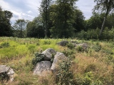
Neolithic and Bronze AgeSite Name: Enemærket SkovCountry: Denmark County: Sjælland Type: Burial Chamber or Dolmen
Nearest Town: Slagelse Nearest Village: Ruds Vedby
Latitude: 55.530420N Longitude: 11.397044E
Condition:
| 5 | Perfect |
| 4 | Almost Perfect |
| 3 | Reasonable but with some damage |
| 2 | Ruined but still recognisable as an ancient site |
| 1 | Pretty much destroyed, possibly visible as crop marks |
| 0 | No data. |
| -1 | Completely destroyed |
| 5 | Superb |
| 4 | Good |
| 3 | Ordinary |
| 2 | Not Good |
| 1 | Awful |
| 0 | No data. |
| 5 | Can be driven to, probably with disabled access |
| 4 | Short walk on a footpath |
| 3 | Requiring a bit more of a walk |
| 2 | A long walk |
| 1 | In the middle of nowhere, a nightmare to find |
| 0 | No data. |
| 5 | co-ordinates taken by GPS or official recorded co-ordinates |
| 4 | co-ordinates scaled from a detailed map |
| 3 | co-ordinates scaled from a bad map |
| 2 | co-ordinates of the nearest village |
| 1 | co-ordinates of the nearest town |
| 0 | no data |
Internal Links:
External Links:
I have visited· I would like to visit
Tonnox visited on 1st Feb 1994 - their rating: Cond: 4 Amb: 5 Access: 2
")
Small forest dolmen which is located on the edge of a ravine, the kerbstones in two layers is probably of later date.
More information at www.kulturarv.dk: Danish Sites and Monuments Record: 030211-58
"Fortidsmindedata Copyright Kulturarvsstyrelsen.
You may be viewing yesterday's version of this page. To see the most up to date information please register for a free account.
")
")
")
")
")
")
")
")
")
")
")
")
Do not use the above information on other web sites or publications without permission of the contributor.
Click here to see more info for this site
Nearby sites
Click here to view sites on an interactive map of the areaKey: Red: member's photo, Blue: 3rd party photo, Yellow: other image, Green: no photo - please go there and take one, Grey: site destroyed
Download sites to:
KML (Google Earth)
GPX (GPS waypoints)
CSV (Garmin/Navman)
CSV (Excel)
To unlock full downloads you need to sign up as a Contributory Member. Otherwise downloads are limited to 50 sites.
Turn off the page maps and other distractions
Nearby sites listing. In the following links * = Image available
886m W 277° Ruds Vedby Langdysse 2* Long Barrow
977m NNE 34° Ruds Vedby Langdysse 1* Long Barrow
978m NNW 342° Ruds Vedby Langdysse 4* Long Barrow
984m E 89° Ruds Vedby Runddysse 1* Burial Chamber or Dolmen
1.1km NNE 28° Ruds Vedby Langdysse 5* Long Barrow
1.2km NNE 31° Ruds Vedby Jættestue* Passage Grave
1.3km NE 44° Ruds Vedby Runddysse 3* Burial Chamber or Dolmen
1.4km ENE 74° Ruds Vedby Runddysse 2* Burial Chamber or Dolmen
1.4km ESE 110° Kragevig Runddysse 2 Burial Chamber or Dolmen
1.6km SSE 153° Kragevig Runddysse 1* Burial Chamber or Dolmen
1.7km ENE 60° Ruds Vedby Conradineslyst Langdysse 2* Long Barrow
2.1km E 100° Sobjerg Runddysse 1 Burial Chamber or Dolmen
2.1km ESE 113° Sobjerg Runddysse 2 Burial Chamber or Dolmen
2.3km ENE 75° Ruds Vedby Langdysse 3* Long Barrow
2.3km N 1° Reerslev Langdysse 1* Long Barrow
2.4km W 277° Ruds Vedby Havedysse Long Barrow
2.5km N 358° Reerslev Megalitgrav 3* Burial Chamber or Dolmen
2.5km N 357° Reerslev Megalitgrav 2* Burial Chamber or Dolmen
2.7km N 3° Reerslev Rævsbjerg Megalitgrav* Burial Chamber or Dolmen
2.7km E 83° Skellebjerg Langdysse* Long Barrow
2.8km NW 307° Sangravsmark Runddysse* Burial Chamber or Dolmen
2.9km N 9° Reerslev Runddysse 3* Burial Chamber or Dolmen
3.0km E 83° Skellebjerg Jættestue* Passage Grave
3.0km ENE 62° Ruds Vedby Conradineslyst Runddysse* Burial Chamber or Dolmen
3.1km WNW 290° Blodstenen (Ruds Vedby)* Rock Art
View more nearby sites and additional images


 We would like to know more about this location. Please feel free to add a brief description and any relevant information in your own language.
 Wir möchten mehr über diese Stätte erfahren. Bitte zögern Sie nicht, eine kurze Beschreibung und relevante Informationen in Deutsch hinzuzufügen.
 Nous aimerions en savoir encore un peu sur les lieux. S'il vous plaît n'hesitez pas à ajouter une courte description et tous les renseignements pertinents dans votre propre langue.
 Quisieramos informarnos un poco más de las lugares. No dude en añadir una breve descripción y otros datos relevantes en su propio idioma.