


<< Our Photo Pages >> Harald Blåtand Stone Wolin - Modern Stone Circle etc in Poland in Zachodniopomorskie
Submitted by Boeddel on Friday, 02 August 2019 Page Views: 913
Modern SitesSite Name: Harald Blåtand Stone WolinCountry: Poland Voivodeship: Zachodniopomorskie Type: Modern Stone Circle etc
Nearest Town: Wolin
Latitude: 53.843920N Longitude: 14.617151E
Condition:
| 5 | Perfect |
| 4 | Almost Perfect |
| 3 | Reasonable but with some damage |
| 2 | Ruined but still recognisable as an ancient site |
| 1 | Pretty much destroyed, possibly visible as crop marks |
| 0 | No data. |
| -1 | Completely destroyed |
| 5 | Superb |
| 4 | Good |
| 3 | Ordinary |
| 2 | Not Good |
| 1 | Awful |
| 0 | No data. |
| 5 | Can be driven to, probably with disabled access |
| 4 | Short walk on a footpath |
| 3 | Requiring a bit more of a walk |
| 2 | A long walk |
| 1 | In the middle of nowhere, a nightmare to find |
| 0 | No data. |
| 5 | co-ordinates taken by GPS or official recorded co-ordinates |
| 4 | co-ordinates scaled from a detailed map |
| 3 | co-ordinates scaled from a bad map |
| 2 | co-ordinates of the nearest village |
| 1 | co-ordinates of the nearest town |
| 0 | no data |
Internal Links:
External Links:
I have visited· I would like to visit
Boeddel visited on 2nd Aug 2019 - their rating: Cond: 5 Access: 4
")
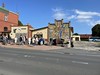
The runic stone of Harald Bluetooth (Harald Blåtand) in Wolin is made in the same style as the rune stone in Jelling (Denmark).
The stone was made by Erik Sandquist in collaboration with researcher Michael Lerche Nielsen from the University of Copenhagen.
You may be viewing yesterday's version of this page. To see the most up to date information please register for a free account.
")
")
")
")
Do not use the above information on other web sites or publications without permission of the contributor.
Nearby Images from Flickr


The above images may not be of the site on this page, but were taken nearby. They are loaded from Flickr so please click on them for image credits.
Click here to see more info for this site
Nearby sites
Click here to view sites on an interactive map of the areaKey: Red: member's photo, Blue: 3rd party photo, Yellow: other image, Green: no photo - please go there and take one, Grey: site destroyed
Download sites to:
KML (Google Earth)
GPX (GPS waypoints)
CSV (Garmin/Navman)
CSV (Excel)
To unlock full downloads you need to sign up as a Contributory Member. Otherwise downloads are limited to 50 sites.
Turn off the page maps and other distractions
Nearby sites listing. In the following links * = Image available
47m N 354° Muzeum Regionalne Wolin* Museum
366m SSE 147° Centrum Słowian i Wikingów* Museum
1.9km SSW 214° Kurhany Wolin* Barrow Cemetery
2.6km S 180° Kurhan Gogolice* Round Barrow(s)
11.7km NNW 342° Grodzisko Warnowo Promontory Fort / Cliff Castle
13.3km N 359° Grodzisko Kołczewo Promontory Fort / Cliff Castle
23.4km NE 34° Wrzosowo Chambered Tomb 2 Chambered Tomb
23.4km NE 34° Wrzosowo Chambered Tomb 1 Chambered Tomb
23.5km E 98° Kłęby Chambered Tomb 1 Chambered Tomb
23.6km E 98° Kłęby Chambered Tomb 2 Chambered Tomb
23.6km E 98° Kłęby Chambered Tomb 3 Chambered Tomb
23.6km E 98° Kłęby Chambered Tomb 4 Chambered Tomb
36.7km WNW 283° Laboemitz Steingrab* Chambered Tomb
37.1km WNW 286° Hünengrab Benz Chambered Tomb
38.7km SW 219° Hügelgrab Glashütte Vorpommern* Round Barrow(s)
39.9km WNW 283° Bratheringsberg Chambered Tomb
42.2km ESE 115° Jarchlino Chambered Tomb I Chambered Tomb
42.4km ESE 115° Jarchlino Chambered Tomb II Chambered Tomb
42.5km SSW 198° Archeological site 53* Ancient Village or Settlement
43.0km SSW 201° Kurhan Dobra* Round Barrow(s)
44.0km SSW 203° Kurhany Dobra* Barrow Cemetery
44.1km W 281° Suckow Steingrab* Chambered Tomb
45.6km SW 217° Schälchenstein Rothenklempenow* Rock Art
46.6km S 185° Grodzisko Szczecin* Hillfort
47.2km SSW 210° Rillenstein Plöwen 44* Carving
View more nearby sites and additional images


 We would like to know more about this location. Please feel free to add a brief description and any relevant information in your own language.
 Wir möchten mehr über diese Stätte erfahren. Bitte zögern Sie nicht, eine kurze Beschreibung und relevante Informationen in Deutsch hinzuzufügen.
 Nous aimerions en savoir encore un peu sur les lieux. S'il vous plaît n'hesitez pas à ajouter une courte description et tous les renseignements pertinents dans votre propre langue.
 Quisieramos informarnos un poco más de las lugares. No dude en añadir una breve descripción y otros datos relevantes en su propio idioma.