

<< Our Photo Pages >> Stenkirken Runddysse - Burial Chamber or Dolmen in Denmark in Midtjylland
Submitted by Tonnox on Friday, 14 June 2019 Page Views: 1114
Neolithic and Bronze AgeSite Name: Stenkirken RunddysseCountry: Denmark County: Midtjylland Type: Burial Chamber or Dolmen
Nearest Town: Knebel Nearest Village: Vrinners
Latitude: 56.239820N Longitude: 10.508870E
Condition:
| 5 | Perfect |
| 4 | Almost Perfect |
| 3 | Reasonable but with some damage |
| 2 | Ruined but still recognisable as an ancient site |
| 1 | Pretty much destroyed, possibly visible as crop marks |
| 0 | No data. |
| -1 | Completely destroyed |
| 5 | Superb |
| 4 | Good |
| 3 | Ordinary |
| 2 | Not Good |
| 1 | Awful |
| 0 | No data. |
| 5 | Can be driven to, probably with disabled access |
| 4 | Short walk on a footpath |
| 3 | Requiring a bit more of a walk |
| 2 | A long walk |
| 1 | In the middle of nowhere, a nightmare to find |
| 0 | No data. |
| 5 | co-ordinates taken by GPS or official recorded co-ordinates |
| 4 | co-ordinates scaled from a detailed map |
| 3 | co-ordinates scaled from a bad map |
| 2 | co-ordinates of the nearest village |
| 1 | co-ordinates of the nearest town |
| 0 | no data |
Internal Links:
External Links:
I have visited· I would like to visit
Tonnox has visited here
")
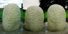
Round Dolmen (Danish: Runddysse = Dolmen chamber within circular enclosure) with 15 stones. Protected in 1934. More information at www.kulturarv.dk: Danish Sites and Monuments Record: 140501-9
"Fortidsmindedata Copyright Kulturarvsstyrelsen"
You may be viewing yesterday's version of this page. To see the most up to date information please register for a free account.
")
")
")
")
")
")
")
")
")
")
")
")
")
")
")
")
")
")
Do not use the above information on other web sites or publications without permission of the contributor.
Click here to see more info for this site
Nearby sites
Click here to view sites on an interactive map of the areaKey: Red: member's photo, Blue: 3rd party photo, Yellow: other image, Green: no photo - please go there and take one, Grey: site destroyed
Download sites to:
KML (Google Earth)
GPX (GPS waypoints)
CSV (Garmin/Navman)
CSV (Excel)
To unlock full downloads you need to sign up as a Contributory Member. Otherwise downloads are limited to 50 sites.
Turn off the page maps and other distractions
Nearby sites listing. In the following links * = Image available
782m SSE 149° Agri Grovlegård Runddysse* Burial Chamber or Dolmen
927m ESE 111° Agri Stabelhøje* Round Barrow(s)
1.3km SSW 192° Andrup Runddysse* Burial Chamber or Dolmen
1.6km SSE 157° Agri Jættestue Passage Grave
1.6km SSE 166° Agri Dysse* Burial Chamber or Dolmen
1.9km SSW 196° Knebel Langdysse Long Barrow
2.4km SSW 197° Knebel Runddysse* Burial Chamber or Dolmen
2.4km WSW 247° Rolsøgård Runddysse 2 Burial Chamber or Dolmen
2.4km S 190° Knebel Poskær Stenhus* Burial Chamber or Dolmen
2.5km E 91° Barsballe Runddysse Burial Chamber or Dolmen
2.6km NE 35° Grønfeld Megalitgrav Burial Chamber or Dolmen
2.7km WSW 250° Rolsøgård Runddysse 1* Burial Chamber or Dolmen
2.9km NNE 12° Egens Runddysse* Burial Chamber or Dolmen
3.4km N 355° Egens Hundshoved Langdysse* Long Barrow
3.4km N 1° Egens Langdysse* Long Barrow
3.6km SSE 165° Læggerholm Jættestue Passage Grave
3.6km ENE 56° Skårup Megalitgrav Burial Chamber or Dolmen
3.7km S 185° Lynge Stenhus Runddysse Passage Grave
4.1km SSE 161° Viderup Trehøje* Barrow Cemetery
4.2km SSE 162° Viderup Stenkiste Cist
4.3km NE 56° Kejlstrup Runddysse Burial Chamber or Dolmen
4.3km N 358° Skovridergård Runddysse* Burial Chamber or Dolmen
4.4km N 357° Ringelmose Skov Runddysse 1 Burial Chamber or Dolmen
4.5km N 357° Ringelmose Skov Stengrav 1 Chambered Tomb
4.5km N 357° Ringelmose Skov Stengrav 2 Chambered Tomb
View more nearby sites and additional images


 We would like to know more about this location. Please feel free to add a brief description and any relevant information in your own language.
 Wir möchten mehr über diese Stätte erfahren. Bitte zögern Sie nicht, eine kurze Beschreibung und relevante Informationen in Deutsch hinzuzufügen.
 Nous aimerions en savoir encore un peu sur les lieux. S'il vous plaît n'hesitez pas à ajouter une courte description et tous les renseignements pertinents dans votre propre langue.
 Quisieramos informarnos un poco más de las lugares. No dude en añadir una breve descripción y otros datos relevantes en su propio idioma.