 with our Megalithic Portal iPhone app")


<< Text Pages >> Eglinton Park - Ancient Village or Settlement in Scotland in North Ayrshire
Submitted by AstroGeologist on Friday, 10 May 2019 Page Views: 991
Multi-periodSite Name: Eglinton Park Alternative Name: Eglinton Mesolithic SettlementCountry: Scotland County: North Ayrshire Type: Ancient Village or Settlement
Nearest Town: Kilwinning Nearest Village: Dreghorn
Map Ref: NS3229642217
Latitude: 55.644475N Longitude: 4.666375W
Condition:
| 5 | Perfect |
| 4 | Almost Perfect |
| 3 | Reasonable but with some damage |
| 2 | Ruined but still recognisable as an ancient site |
| 1 | Pretty much destroyed, possibly visible as crop marks |
| 0 | No data. |
| -1 | Completely destroyed |
| 5 | Superb |
| 4 | Good |
| 3 | Ordinary |
| 2 | Not Good |
| 1 | Awful |
| 0 | No data. |
| 5 | Can be driven to, probably with disabled access |
| 4 | Short walk on a footpath |
| 3 | Requiring a bit more of a walk |
| 2 | A long walk |
| 1 | In the middle of nowhere, a nightmare to find |
| 0 | No data. |
| 5 | co-ordinates taken by GPS or official recorded co-ordinates |
| 4 | co-ordinates scaled from a detailed map |
| 3 | co-ordinates scaled from a bad map |
| 2 | co-ordinates of the nearest village |
| 1 | co-ordinates of the nearest town |
| 0 | no data |
Internal Links:
External Links:
I have visited· I would like to visit
AstroGeologist visited on 26th Oct 2019 - their rating: Cond: 1 Amb: 4 Access: 4 Eglinton Park Settlement :
To the North of the A78 road at Eglinton, is a large Mesolithic settlement.
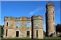
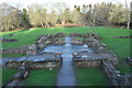
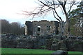
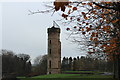
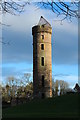
Now home to the ruins of a Castle, the current site covers an area of 400ha (40 of which are woodland) enclosed by the River Garnock to the West, and the Lugton Water to the South and East, this area would have been ideal hunting and fishing grounds for our ancestors.
In the mid 19th century a small Cordoned Cinerary Urn and several other Urns were discovered in a Tumulus near Eglinton Castle (This is now with the National Museum of Antiquities of Scotland) Unfortunately this Tumulus no longer exists.
Not long after, Mr "John Palmer" found a Greenstone Axe-Hammer next to Eglinton Stables, it was 20cm long and perforated near the blunt end. In the Pyetbog at Eglinton Kennels a Stone Axehead was also found.
Several Mesolithic Chert and Flint Blades and Scrapers were found dotted about the area along with some Crop Marks.
Now cut off from the park by the B7080 road, 2 Prehistoric Burials were found when some new homes were being constructed at Montgomerie Park. The land the Cist and Ditch Burial was discovered on is now mostly covered in a modern housing scheme.
You may be viewing yesterday's version of this page. To see the most up to date information please register for a free account.
Do not use the above information on other web sites or publications without permission of the contributor.
Nearby Images from Geograph Britain and Ireland:
©2013(licence)
©2016(licence)
©2016(licence)
©2016(licence)
©2016(licence)
The above images may not be of the site on this page, they are loaded from Geograph.
Please Submit an Image of this site or go out and take one for us!
Click here to see more info for this site
Nearby sites
Key: Red: member's photo, Blue: 3rd party photo, Yellow: other image, Green: no photo - please go there and take one, Grey: site destroyed
Download sites to:
KML (Google Earth)
GPX (GPS waypoints)
CSV (Garmin/Navman)
CSV (Excel)
To unlock full downloads you need to sign up as a Contributory Member. Otherwise downloads are limited to 50 sites.
Turn off the page maps and other distractions
Nearby sites listing. In the following links * = Image available
1.6km W 271° Dirrans burial* Cist (NS30684230)
1.8km ESE 111° Sourlie Hill Modern Stone Circle etc (NS3398041490)
2.8km ESE 119° Lawthorn Mount Barrow Cemetery (NS34654078)
3.0km W 266° Todhill Crannog Crannog (NS2930042101)
3.5km S 183° Grannie Stane* Natural Stone / Erratic / Other Natural Feature (NS3196038711)
4.1km WSW 242° Ardeer Sands Ancient Village or Settlement (NS2857740455)
4.4km W 266° Dubbs Cist Cist (NS27884208)
4.9km SE 141° Dreghorn Neolithic Village Ancient Village or Settlement (NS35183830)
5.1km WNW 292° Ashgrove Loch Crannog* Crannog (NS27594431)
5.2km W 265° Stevenston Souterrain Souterrain (Fogou, Earth House) (NS27114193)
5.2km S 181° Shewalton Moor Ancient Village or Settlement (NS320370)
5.2km N 352° Cleaves Cove* Cave or Rock Shelter (NS31774744)
6.3km WNW 287° Diddup Hillfort Hillfort (NS2636344331)
6.4km SE 144° Dundonald Cursus Cursus (NS35893690)
6.4km SE 145° Drybridge Neolithic Village Ancient Village or Settlement (NS3582336852)
6.8km SE 146° Drybridge* Standing Stone (Menhir) (NS35923644)
7.5km WNW 290° Knockrivoch Mount Barrow Cemetery (NS25344510)
8.0km NNW 335° Courthill Cairn* Round Barrow(s) (NS29244958)
8.7km SSE 150° Dun Donald Hillfort (NS36363451)
8.7km WNW 301° Blackshaw Moor Stone Circle (NS250470)
9.1km W 268° Ardrossan Shell Mound* Artificial Mound (NS23134218)
9.2km SSE 157° Kemp Law* Stone Fort or Dun (NS35583364)
9.3km E 80° Buiston Crannog* Crannog (NS41554352)
10.1km SSE 157° Wardlaw Hill Fort Hillfort (NS35923276)
10.4km SSE 157° Harpercroft Hillfort Hillfort (NS36003252)
View more nearby sites and additional images


 We would like to know more about this location. Please feel free to add a brief description and any relevant information in your own language.
 Wir möchten mehr über diese Stätte erfahren. Bitte zögern Sie nicht, eine kurze Beschreibung und relevante Informationen in Deutsch hinzuzufügen.
 Nous aimerions en savoir encore un peu sur les lieux. S'il vous plaît n'hesitez pas à ajouter une courte description et tous les renseignements pertinents dans votre propre langue.
 Quisieramos informarnos un poco más de las lugares. No dude en añadir una breve descripción y otros datos relevantes en su propio idioma.