


<< Our Photo Pages >> San Nicola Nuraghe - Broch or Nuraghe in Italy in Sardinia (Sardegna)
Submitted by SolarMegalith on Tuesday, 14 August 2018 Page Views: 893
Neolithic and Bronze AgeSite Name: San Nicola NuragheCountry: Italy Region: Sardinia (Sardegna) Type: Broch or Nuraghe
Nearest Town: Orroli
Latitude: 39.696538N Longitude: 9.248101E
Condition:
| 5 | Perfect |
| 4 | Almost Perfect |
| 3 | Reasonable but with some damage |
| 2 | Ruined but still recognisable as an ancient site |
| 1 | Pretty much destroyed, possibly visible as crop marks |
| 0 | No data. |
| -1 | Completely destroyed |
| 5 | Superb |
| 4 | Good |
| 3 | Ordinary |
| 2 | Not Good |
| 1 | Awful |
| 0 | No data. |
| 5 | Can be driven to, probably with disabled access |
| 4 | Short walk on a footpath |
| 3 | Requiring a bit more of a walk |
| 2 | A long walk |
| 1 | In the middle of nowhere, a nightmare to find |
| 0 | No data. |
| 5 | co-ordinates taken by GPS or official recorded co-ordinates |
| 4 | co-ordinates scaled from a detailed map |
| 3 | co-ordinates scaled from a bad map |
| 2 | co-ordinates of the nearest village |
| 1 | co-ordinates of the nearest town |
| 0 | no data |
Internal Links:
External Links:
I have visited· I would like to visit
SolarMegalith visited on 12th Sep 2017 - their rating: Cond: 3 Amb: 3 Access: 4
")
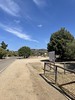
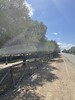
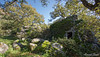
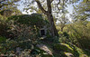
Nuraghe San Nicola is located near the church of the same name. It is another example of nuraghe binato - a two-towered structure with a wall connecting the towers. The southern tower reaches 8m of height, bu its chamber is collapsed. Excavations around the nuraghe revealed traces of a settlement with circular huts.
Reference:
F. Campus, V. Leonelli. 2008. "I nuraghi" in Il paesaggio nuragico sull'altopiano di Pran'e Muru. Edited by F. Lo Schiavo. Comune di Orroli (p. 45).
You may be viewing yesterday's version of this page. To see the most up to date information please register for a free account.
")
")
")
Do not use the above information on other web sites or publications without permission of the contributor.
Nearby Images from Flickr


The above images may not be of the site on this page, but were taken nearby. They are loaded from Flickr so please click on them for image credits.
Click here to see more info for this site
Nearby sites
Click here to view sites on an interactive map of the areaKey: Red: member's photo, Blue: 3rd party photo, Yellow: other image, Green: no photo - please go there and take one, Grey: site destroyed
Download sites to:
KML (Google Earth)
GPX (GPS waypoints)
CSV (Garmin/Navman)
CSV (Excel)
To unlock full downloads you need to sign up as a Contributory Member. Otherwise downloads are limited to 50 sites.
Turn off the page maps and other distractions
Nearby sites listing. In the following links * = Image available
354m N 351° Perdu Foddis Nuraghe* Broch or Nuraghe
747m NNE 30° Su Motti Domus de Janas* Rock Cut Tomb
813m N 355° Salonis Nuraghe* Broch or Nuraghe
1.1km SE 143° Cubingiu Nuraghe* Broch or Nuraghe
1.1km N 356° Pitziogu Nuraghe* Broch or Nuraghe
1.1km NNE 18° Corona Arrubia Nuraghe* Broch or Nuraghe
1.1km ESE 122° Taccu 'e Idda Nuraghe* Broch or Nuraghe
1.2km S 173° Sa Serra Nuraghe* Broch or Nuraghe
1.3km NW 319° Comas de Pisu Nuraghe* Broch or Nuraghe
1.6km SE 146° Cuccuru Nuraghe* Broch or Nuraghe
1.7km SW 219° Martingiana Nuraghe* Broch or Nuraghe
1.9km SE 145° Ollasta Nuraghe* Broch or Nuraghe
2.0km NE 43° S'Arriu Pranemuru Nuraghe* Broch or Nuraghe
2.2km NW 310° Sardajara Nuraghe* Broch or Nuraghe
2.2km SSW 212° Perda Taullas Nuraghe* Broch or Nuraghe
2.3km S 172° Meson'e Sarra Nuraghe* Broch or Nuraghe
2.4km SE 131° Cracina Nuraghe* Broch or Nuraghe
2.8km NNE 29° Corongiu Maria Protonuraghe* Broch or Nuraghe
2.8km E 88° Luas Nuraghe* Broch or Nuraghe
2.9km ENE 70° Perda 'e Putzu Nuraghe* Broch or Nuraghe
3.0km E 99° Funtana Spidu Nuraghe* Broch or Nuraghe
3.1km NE 55° Sedda Bintirissos Protonuraghe* Broch or Nuraghe
3.1km ESE 109° Sa Tanca Manna Nuraghe* Broch or Nuraghe
3.1km W 261° Linnarbus Nuraghe* Broch or Nuraghe
3.1km NNW 337° Latt'e Pudda Nuraghe* Broch or Nuraghe
View more nearby sites and additional images


 We would like to know more about this location. Please feel free to add a brief description and any relevant information in your own language.
 Wir möchten mehr über diese Stätte erfahren. Bitte zögern Sie nicht, eine kurze Beschreibung und relevante Informationen in Deutsch hinzuzufügen.
 Nous aimerions en savoir encore un peu sur les lieux. S'il vous plaît n'hesitez pas à ajouter une courte description et tous les renseignements pertinents dans votre propre langue.
 Quisieramos informarnos un poco más de las lugares. No dude en añadir una breve descripción y otros datos relevantes en su propio idioma.