

<< Our Photo Pages >> Brown Low - Round Barrow(s) in England in Greater Manchester
Submitted by vicky on Thursday, 26 February 2004 Page Views: 14661
Neolithic and Bronze AgeSite Name: Brown LowCountry: England County: Greater Manchester Type: Round Barrow(s)
Nearest Town: Marple
Map Ref: SJ988909 Landranger Map Number: 109
Latitude: 53.414905N Longitude: 2.01952W
Condition:
| 5 | Perfect |
| 4 | Almost Perfect |
| 3 | Reasonable but with some damage |
| 2 | Ruined but still recognisable as an ancient site |
| 1 | Pretty much destroyed, possibly visible as crop marks |
| 0 | No data. |
| -1 | Completely destroyed |
| 5 | Superb |
| 4 | Good |
| 3 | Ordinary |
| 2 | Not Good |
| 1 | Awful |
| 0 | No data. |
| 5 | Can be driven to, probably with disabled access |
| 4 | Short walk on a footpath |
| 3 | Requiring a bit more of a walk |
| 2 | A long walk |
| 1 | In the middle of nowhere, a nightmare to find |
| 0 | No data. |
| 5 | co-ordinates taken by GPS or official recorded co-ordinates |
| 4 | co-ordinates scaled from a detailed map |
| 3 | co-ordinates scaled from a bad map |
| 2 | co-ordinates of the nearest village |
| 1 | co-ordinates of the nearest town |
| 0 | no data |
Internal Links:
External Links:
")
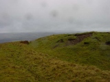
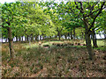
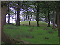
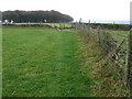
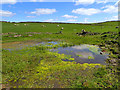
This well formed barrow is located in a private woodland (but visible from a public footpath) in the hills above Marple. It is in excellent condition, despite being covered in trees and is an easy walk from the road. There are stunning views to the west across Marple to Alderley Edge, Manchester and Merseyside. Close by in a field further up the hill lies the cairn known as Ludworth intake which would also have been visible from Brown Low before forestation.
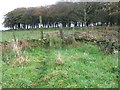
Note: Please note this barrow is located on private land but can be easily viewed from the nearby footpath.
You may be viewing yesterday's version of this page. To see the most up to date information please register for a free account.
 (PID:24015)")
 (PID:24012)")
Do not use the above information on other web sites or publications without permission of the contributor.
Nearby Images from Geograph Britain and Ireland:
©2016(licence)
©2005(licence)
©2009(licence)
©2009(licence)
©2016(licence)
The above images may not be of the site on this page, they are loaded from Geograph.
Please Submit an Image of this site or go out and take one for us!
Click here to see more info for this site
Nearby sites
Key: Red: member's photo, Blue: 3rd party photo, Yellow: other image, Green: no photo - please go there and take one, Grey: site destroyed
Download sites to:
KML (Google Earth)
GPX (GPS waypoints)
CSV (Garmin/Navman)
CSV (Excel)
To unlock full downloads you need to sign up as a Contributory Member. Otherwise downloads are limited to 50 sites.
Turn off the page maps and other distractions
Nearby sites listing. In the following links * = Image available
447m NNE 24° Ludworth Intake* Round Barrow(s) (SJ98989131)
1.8km E 89° Robin Hood's Picking Rods* Ancient Cross (SK0060990941)
1.9km E 90° Chisworth Cupmarked stone* Rock Art (SK007909)
2.1km SSW 197° Mellor Hillfort* Hillfort (SJ982889)
2.1km ESE 104° Ringstones (new circle at Near Slack Farm)* Modern Stone Circle etc (SK0087290394)
2.2km SE 126° Ringstones (Derbyshire)* Stone Circle (SK006896)
2.8km NW 317° Werneth Low Cairn Cairn (SJ969929)
2.8km NW 323° Werneth Low Enclosure Ancient Village or Settlement (SJ97099315)
3.3km NE 47° Hargate Hill* Standing Stone (Menhir) (SK01239315)
3.4km ENE 73° Coombes Edge* Ring Cairn (SK0204591892)
3.5km WNW 303° Werneth Low (Hyde) Ancient Village or Settlement (SJ959928)
3.5km NW 318° Hangingbank, Werneth Low* Ancient Village or Settlement (SJ96479352)
3.7km S 182° Mellor Moor* Cairn (SJ9867187246)
3.7km NW 314° Lower Higham Farm Cairn (SJ961935)
4.9km W 263° St Chad's Well (Chadkirk)* Holy Well or Sacred Spring (SJ93979027)
5.9km ENE 64° Carr House Lane standing stone Standing Stone (Menhir) (SK041935)
5.9km NE 41° Mouselow Castle Hillfort (SK027954)
6.3km N 1° Buckton Edge Cairn (SJ989972)
6.3km N 3° Hobson Moor Cairn II Cairn (SJ991972)
6.6km SSW 192° St Mary (Disley)* Ancient Cross (SJ97388444)
6.6km SE 129° Watery Hey Well* Holy Well or Sacred Spring (SK0399986733)
7.0km SE 127° Whitworth Well* Holy Well or Sacred Spring (SK0437786691)
7.1km N 1° Stalybridge Cairn* Cairn (SJ989980)
7.1km N 2° Hobson Moor Cairn I Cairn (SJ990980)
7.5km ESE 119° Upper Dole Field Well* Holy Well or Sacred Spring (SK054872)
View more nearby sites and additional images


 We would like to know more about this location. Please feel free to add a brief description and any relevant information in your own language.
 Wir möchten mehr über diese Stätte erfahren. Bitte zögern Sie nicht, eine kurze Beschreibung und relevante Informationen in Deutsch hinzuzufügen.
 Nous aimerions en savoir encore un peu sur les lieux. S'il vous plaît n'hesitez pas à ajouter une courte description et tous les renseignements pertinents dans votre propre langue.
 Quisieramos informarnos un poco más de las lugares. No dude en añadir una breve descripción y otros datos relevantes en su propio idioma.