

<< Our Photo Pages >> Coldstone Beck 02 - Rock Art in England in Yorkshire (West)
Submitted by Anne T on Sunday, 28 January 2018 Page Views: 1047
Rock ArtSite Name: Coldstone Beck 02 Alternative Name: ERA-2369; IAG388d; CB02Country: England County: Yorkshire (West) Type: Rock Art
Nearest Town: Otley Nearest Village: Burley Woodhead
Map Ref: SE1446644907
Latitude: 53.900132N Longitude: 1.78133W
Condition:
| 5 | Perfect |
| 4 | Almost Perfect |
| 3 | Reasonable but with some damage |
| 2 | Ruined but still recognisable as an ancient site |
| 1 | Pretty much destroyed, possibly visible as crop marks |
| 0 | No data. |
| -1 | Completely destroyed |
| 5 | Superb |
| 4 | Good |
| 3 | Ordinary |
| 2 | Not Good |
| 1 | Awful |
| 0 | No data. |
| 5 | Can be driven to, probably with disabled access |
| 4 | Short walk on a footpath |
| 3 | Requiring a bit more of a walk |
| 2 | A long walk |
| 1 | In the middle of nowhere, a nightmare to find |
| 0 | No data. |
| 5 | co-ordinates taken by GPS or official recorded co-ordinates |
| 4 | co-ordinates scaled from a detailed map |
| 3 | co-ordinates scaled from a bad map |
| 2 | co-ordinates of the nearest village |
| 1 | co-ordinates of the nearest town |
| 0 | no data |
Be the first person to rate this site - see the 'Contribute!' box in the right hand menu.
Internal Links:
External Links:
")
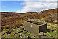
This rock art panel is recorded as having two single cups with two further cup-like depressions close by near the centre of the rock. Another depression has a distinctive weathering channel running from it; this channel has possibly been enhanced by carving. For more information see England's Rock art entry for ERA-2369 Coldstone Beck 02 which includes a detailed description, photographs, a plan of the rock and its motifs, plus photogrammetry.
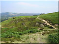
This panel is also described in Boughey & Vickerman's "Prehistoric Rock Art of the West Riding Supplement (2018)", pages 177 and 178. The Supplement includes a photograph of the rock in its landscape setting, together with photographs of its motifs. B&V adds: " (this is an) isolated medium to large rock … with distinctive large natural (water worn?) basin immediately alongside (north) of the footpath across the edge of Burley Moor with wide view of Wharfe Valley, Otley Chevin and Carr Dam to the east."
This rock is located on Open Access land.
Note: Have you seen this rock art panel? Do you have any photographs or information to add?
You may be viewing yesterday's version of this page. To see the most up to date information please register for a free account.
Do not use the above information on other web sites or publications without permission of the contributor.
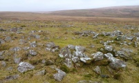
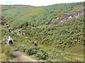
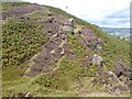
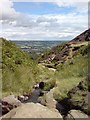
Nearby Images from Geograph Britain and Ireland:
©2007(licence)
©2007(licence)
©2007(licence)
©2006(licence)
©2017(licence)
The above images may not be of the site on this page, they are loaded from Geograph.
Please Submit an Image of this site or go out and take one for us!
Click here to see more info for this site
Nearby sites
Key: Red: member's photo, Blue: 3rd party photo, Yellow: other image, Green: no photo - please go there and take one, Grey: site destroyed
Download sites to:
KML (Google Earth)
GPX (GPS waypoints)
CSV (Garmin/Navman)
CSV (Excel)
To unlock full downloads you need to sign up as a Contributory Member. Otherwise downloads are limited to 50 sites.
Turn off the page maps and other distractions
Nearby sites listing. In the following links * = Image available
243m W 266° Burley Moor 10* Rock Art (SE1422344890)
306m W 267° Burley Moor (Lower Lanshaw Dam 1) Rock Art (SE14164489)
323m NNW 348° Chair Stone (Burley Moor)* Rock Art (SE1439545222)
339m NW 312° Burley Moor 09* Rock Art (SE1421245132)
346m NW 313° Coldstone Beck Cairn 1 (Burley Moor) Cairn (SE14214514)
426m NNW 337° Coldstone Beck (Burley Moor) Rock Art (SE143453)
499m SW 219° Great Skirtful Ring (Burley Moor) Ring Cairn (SE14154452)
540m SW 229° Great Skirtful of Stones* Cairn (SE14064455)
549m WNW 302° Dyke Stone (Burley Moor) Rock Art (SE140452)
574m NNW 337° Cold Stone (Burley Moor)* Standing Stone (Menhir) (SE1423645433)
584m WNW 294° Burley Moor 08* Rock Art (SE1392845139)
586m NW 324° Woofa Bank 20* Rock Art (SE1412045381)
594m WNW 293° Burley Moor 07* Rock Art (SE1391645135)
600m WNW 293° Burley Moor 06* Rock Art (SE1391345144)
611m WNW 291° Burley Moor 05* Rock Art (SE1389445126)
621m WNW 293° Burley Moor 04* Rock Art (SE1389145147)
651m SSE 166° Craven Hall Hill 02* Rock Art (SE1462244274)
666m NW 319° Woofa Bank 19* Rock Art (SE1402745409)
682m NNW 334° Stead Crag 03* Rock Art (SE1416045517)
685m WNW 294° Little Skirtful of Stones Cairn 03 Rock Art (SE1384045189)
688m NW 321° Rushy Beck Spring (Burley Moor) Holy Well or Sacred Spring (SE14034544)
688m WNW 294° Little Skirtful of Stones Cairn 04 Rock Art (SE1383345180)
688m WNW 294° Little Skirtful of Stones* Ring Cairn (SE1383745190)
689m WNW 294° Little Skirtful of Stones Cairn 06 Rock Art (SE1383245180)
689m WNW 294° Little Skirtful of Stones Cairn 11 Rock Art (SE1383545187)
View more nearby sites and additional images


 We would like to know more about this location. Please feel free to add a brief description and any relevant information in your own language.
 Wir möchten mehr über diese Stätte erfahren. Bitte zögern Sie nicht, eine kurze Beschreibung und relevante Informationen in Deutsch hinzuzufügen.
 Nous aimerions en savoir encore un peu sur les lieux. S'il vous plaît n'hesitez pas à ajouter une courte description et tous les renseignements pertinents dans votre propre langue.
 Quisieramos informarnos un poco más de las lugares. No dude en añadir una breve descripción y otros datos relevantes en su propio idioma.