

<< Our Photo Pages >> New Hagg (Hallam Moors) - Standing Stone (Menhir) in England in Yorkshire (South)
Submitted by Anne T on Wednesday, 06 December 2017 Page Views: 1606
Neolithic and Bronze AgeSite Name: New Hagg (Hallam Moors)Country: England County: Yorkshire (South) Type: Standing Stone (Menhir)
Nearest Town: Sheffield Nearest Village: Hollow Meadows
Map Ref: SK2581587058
Latitude: 53.379747N Longitude: 1.613396W
Condition:
| 5 | Perfect |
| 4 | Almost Perfect |
| 3 | Reasonable but with some damage |
| 2 | Ruined but still recognisable as an ancient site |
| 1 | Pretty much destroyed, possibly visible as crop marks |
| 0 | No data. |
| -1 | Completely destroyed |
| 5 | Superb |
| 4 | Good |
| 3 | Ordinary |
| 2 | Not Good |
| 1 | Awful |
| 0 | No data. |
| 5 | Can be driven to, probably with disabled access |
| 4 | Short walk on a footpath |
| 3 | Requiring a bit more of a walk |
| 2 | A long walk |
| 1 | In the middle of nowhere, a nightmare to find |
| 0 | No data. |
| 5 | co-ordinates taken by GPS or official recorded co-ordinates |
| 4 | co-ordinates scaled from a detailed map |
| 3 | co-ordinates scaled from a bad map |
| 2 | co-ordinates of the nearest village |
| 1 | co-ordinates of the nearest town |
| 0 | no data |
Be the first person to rate this site - see the 'Contribute!' box in the right hand menu.
Internal Links:
External Links:
I have visited· I would like to visit
a60wattfish would like to visit
Pressure visited on 30th Sep 2023 - their rating: Cond: 4 Amb: 5 Access: 3 I had an excellent visit to this beautiful stone this morning. Despite the heather it’s not that hard to find. Park on Redmires Road / Long Causeway in the first car park after you’ve gone past Wyoming Brook, head straight up the path for a kilometre, and you’ll see the stone on your right about 100 meters into the moor. There’s no specific path to the stone and you need to take some care getting through the heather.
It’s close by to the magnificent Headstone which dominates the view of this side of the valley from the A57 and not from Wyoming Brook’s Ash Cabin flat area with the stone circle, menhir and rock shelter, as well as other features. This whole moor is almost like Stanton Drew - clearly a ritual landscape with lots going on and a strong relationship with the wilds of the peak and Lose Hill in the distance. It’s a good family walk even if you don’t go up the stone itself.
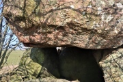
The stone itself is not alone - there are many other recumbents around it, possibly an embankment, as well as several big stones half covered by heather within a few meters, and a cairn a little up the slope. It’s looking well looked after, which is gratifying.
Bear in mind that Redmires Road is likely to be significant - it was called ancient in 1318, and was a Roman road which seems likely to have overlain an existing old track. There’s a lot going on in Redmires!
 (PID:264341)")
The Northern Antiquarian (TNA) features a page for this standing stone - see their entry for New Hagg Standing Stone, Hallam Moors, South Yorkshire, which gives directions for finding this stone, together with photographs and a description.
Paul Bennett says "I didn't know of its existence until I found it whilst wandering the moor one day. Though I can find no record of it anywhere, the weathering on its top in comparison with other authentic standing stones suggest that it’s been stood for a very long time and probably since prehistory. Four feet tall, the stone stands roughly half a kilometre SSE from the Headstone which can be seen from here – and roughly half a kilometre from the Reddicar Clough Long Cist, ESE of here."
Note: Have you visited this site? Do you have any photographs or information to add?
You may be viewing yesterday's version of this page. To see the most up to date information please register for a free account.
 (PID:264346)")
 (PID:264345)")
 (PID:264344)")
 (PID:264343)")
 (PID:264342)")
Do not use the above information on other web sites or publications without permission of the contributor.
Click here to see more info for this site
Nearby sites
Key: Red: member's photo, Blue: 3rd party photo, Yellow: other image, Green: no photo - please go there and take one, Grey: site destroyed
Download sites to:
KML (Google Earth)
GPX (GPS waypoints)
CSV (Garmin/Navman)
CSV (Excel)
To unlock full downloads you need to sign up as a Contributory Member. Otherwise downloads are limited to 50 sites.
Turn off the page maps and other distractions
Nearby sites listing. In the following links * = Image available
460m ESE 113° Reddicar Clough (Hallam Moor) Cairn (SK26248688)
1.4km ESE 119° Ash Cabin standing stone* Standing Stone (Menhir) (SK270864)
1.4km SE 126° Ash Cabin Flat* Stone Circle (SK2693186251)
1.4km ESE 117° Ash Cabin Fort* Hillfort (SK271864)
3.7km SSW 203° Robin Hood's Cave* Cave or Rock Shelter (SK244836)
4.0km SW 225° Sheepwash Bank Cairn (SK230842)
4.1km SW 215° North Lees Romano British Village* Ancient Village or Settlement (SK2343083673)
4.2km SW 226° Dennis Knoll* Cairn (SK228841)
4.3km W 268° Seven Stones Of Hordron* Stone Circle (SK2152486851)
4.4km WSW 255° Moscar Moor* Stone Circle (SK21608591)
4.4km SSW 214° Trinity Well (Hathersage)* Holy Well or Sacred Spring (SK234834)
4.5km SW 236° Bamford Moor South* Stone Circle (SK22118453)
4.5km WSW 238° The Old Woman Stone* Standing Stone (Menhir) (SK22018467)
4.7km WSW 240° Stone on Bamford Moor* Standing Stone (Menhir) (SK21798470)
4.9km WSW 243° Bamford Moor Central* Cairn (SK215848)
5.0km W 262° Priddock Wood Cairn (SK209863)
5.2km WSW 251° Bamford Moor North Ring Cairn (SK209853)
5.2km SSE 153° Harrys Stone* Ancient Temple (SK282824)
5.4km W 269° Ladybower Tor* Rock Art (SK204869)
5.5km SSE 154° God's Spring* Holy Well or Sacred Spring (SK283821)
5.6km N 10° St Nicholas (Bradfield) Ancient Cross (SK26729254)
5.6km S 178° Carl Wark* Hillfort (SK260815)
5.8km S 185° Winyards Nick* Round Barrow(s) (SK253813)
6.2km S 181° Hathersage Moor Ring Cairn (SK257809)
6.3km SSW 208° Healing Spring* Holy Well or Sacred Spring (SK229815)
View more nearby sites and additional images


 We would like to know more about this location. Please feel free to add a brief description and any relevant information in your own language.
 Wir möchten mehr über diese Stätte erfahren. Bitte zögern Sie nicht, eine kurze Beschreibung und relevante Informationen in Deutsch hinzuzufügen.
 Nous aimerions en savoir encore un peu sur les lieux. S'il vous plaît n'hesitez pas à ajouter une courte description et tous les renseignements pertinents dans votre propre langue.
 Quisieramos informarnos un poco más de las lugares. No dude en añadir una breve descripción y otros datos relevantes en su propio idioma.