

<< Our Photo Pages >> Jenny Bradley Cross - Ancient Cross in England in Yorkshire (North)
Submitted by johndhunter on Monday, 09 October 2017 Page Views: 1847
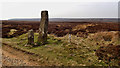
Early Medieval (Dark Age)Site Name: Jenny Bradley CrossCountry: England County: Yorkshire (North) Type: Ancient Cross
Nearest Village: Ingleby Greenhowe
Map Ref: NZ6112502309
Latitude: 54.412568N Longitude: 1.059683W
Condition:
| 5 | Perfect |
| 4 | Almost Perfect |
| 3 | Reasonable but with some damage |
| 2 | Ruined but still recognisable as an ancient site |
| 1 | Pretty much destroyed, possibly visible as crop marks |
| 0 | No data. |
| -1 | Completely destroyed |
| 5 | Superb |
| 4 | Good |
| 3 | Ordinary |
| 2 | Not Good |
| 1 | Awful |
| 0 | No data. |
| 5 | Can be driven to, probably with disabled access |
| 4 | Short walk on a footpath |
| 3 | Requiring a bit more of a walk |
| 2 | A long walk |
| 1 | In the middle of nowhere, a nightmare to find |
| 0 | No data. |
| 5 | co-ordinates taken by GPS or official recorded co-ordinates |
| 4 | co-ordinates scaled from a detailed map |
| 3 | co-ordinates scaled from a bad map |
| 2 | co-ordinates of the nearest village |
| 1 | co-ordinates of the nearest town |
| 0 | no data |
Be the first person to rate this site - see the 'Contribute!' box in the right hand menu.
Internal Links:
External Links:
")
This is recorded as Historic England list entry number 1010084 where full details and a technical description can be found there
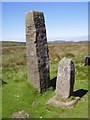
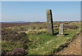
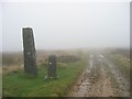
It is a Wayside Cross located just north of Bloworth Crossing on Rudland Rigg beside an ancient drovers road now part of the Cleveland Way. It consists of a broken shaft set in a medieval base. It is the smaller of the two stones at this location. The large stone next to it is a Feversham Estate boundary stone.
Bradley is supposedly a corruption of “Breadless” a place where beggars gathered.
Jenny though a cross is regarded as the sister of the standing stone Margery Bradley near Flat Howe on the Castleton to Hutton Le Hole Road.
You may be viewing yesterday's version of this page. To see the most up to date information please register for a free account.
")
Do not use the above information on other web sites or publications without permission of the contributor.
Nearby Images from Geograph Britain and Ireland:
©2019(licence)
©2020(licence)
©2005(licence)
©2019(licence)
![NZ6102 : The Jenny Bradley cross [remains of] by steven ruffles](https://s3.geograph.org.uk/geophotos/04/36/51/4365183_7363784a_120x120.jpg)
©2015(licence)
The above images may not be of the site on this page, they are loaded from Geograph.
Please Submit an Image of this site or go out and take one for us!
Click here to see more info for this site
Nearby sites
Key: Red: member's photo, Blue: 3rd party photo, Yellow: other image, Green: no photo - please go there and take one, Grey: site destroyed
Download sites to:
KML (Google Earth)
GPX (GPS waypoints)
CSV (Garmin/Navman)
CSV (Excel)
To unlock full downloads you need to sign up as a Contributory Member. Otherwise downloads are limited to 50 sites.
Turn off the page maps and other distractions
Nearby sites listing. In the following links * = Image available
998m NNW 341° Burton Howe* Round Barrow(s) (NZ60790325)
1.0km SSE 152° Rudland Rigg Guide Stone GS2* Marker Stone (NZ6161301430)
1.1km NNW 343° Ingleby Greenhow Cairns* Round Cairn (NZ6078703333)
1.6km E 81° Job Cross (Stony Ridge - Stockdale Moor)* Marker Stone (NZ6268902564)
1.7km WSW 240° Face Stone (Urra Moor)* Standing Stone (Menhir) (NZ5968701442)
1.8km WSW 248° Round Hill East* Round Barrow(s) (NZ59430159)
1.9km WSW 246° Hand Stone (Urra Moor)* Standing Stone (Menhir) (NZ5942701513)
2.0km SSW 201° Badger Stone (Todd Intake Moor)* Natural Stone / Erratic / Other Natural Feature (NZ6044500423)
2.0km NNW 340° Hand Stone (Ingleby Moor)* Marker Stone (NZ6041004222)
2.1km WSW 251° Round Hill West* Cairn (NZ5913101602)
2.5km W 270° Carr Ridge Cairn (Urra Moor)* Cairn (NZ5859702283)
2.6km WSW 243° North Gill Head (Urra Moor)* Rock Art (NZ5884101119)
2.6km SSW 197° Bransdale Moor Stone Circle Stone Circle (SE604998)
2.8km N 9° Cheese Stones* Natural Stone / Erratic / Other Natural Feature (NZ6154405038)
2.8km SSE 148° Cammon Stone* Standing Stone (Menhir) (SE6263199980)
2.8km SW 230° High Cable Stone (Tripsdale)* Natural Stone / Erratic / Other Natural Feature (NZ5896400446)
2.9km WSW 237° Collar Ridge Pillar Cairn* Cairn (NZ5866800700)
3.0km SSW 204° Crook Staff Hill* Round Barrow(s) (SE5993599584)
3.0km SW 229° Upper Tripsdale Earthwork* Misc. Earthwork (NZ5887500296)
3.0km S 171° High Plantation (Bransdale Moor)* Round Cairn (SE6165499324)
3.1km SW 233° Collar Ridge Marker Stone* Marker Stone (NZ5868400435)
3.2km SW 228° Low Cable Stone (Tripsdale)* Natural Stone / Erratic / Other Natural Feature (NZ5878400147)
3.3km E 100° Great Howdale* Cairn (NZ6441001749)
3.4km N 9° Baysdale Cross (Middle Head)* Ancient Cross (NZ6163205633)
3.4km W 268° Cheshire Stone (Urra Moor)* Natural Stone / Erratic / Other Natural Feature (NZ5772902118)
View more nearby sites and additional images


 We would like to know more about this location. Please feel free to add a brief description and any relevant information in your own language.
 Wir möchten mehr über diese Stätte erfahren. Bitte zögern Sie nicht, eine kurze Beschreibung und relevante Informationen in Deutsch hinzuzufügen.
 Nous aimerions en savoir encore un peu sur les lieux. S'il vous plaît n'hesitez pas à ajouter une courte description et tous les renseignements pertinents dans votre propre langue.
 Quisieramos informarnos un poco más de las lugares. No dude en añadir una breve descripción y otros datos relevantes en su propio idioma.