

<< Our Photo Pages >> Ad Mercuri - Ancient Village or Settlement in Morocco
Submitted by TimCullis on Thursday, 23 February 2017 Page Views: 2536
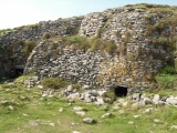
Multi-periodSite Name: Ad Mercuri Alternative Name: Colonia ZilliCountry: Morocco Type: Ancient Village or Settlement
Nearest Town: Asilah Nearest Village: Had Rharbia
Latitude: 35.522111N Longitude: 5.915194W
Condition:
| 5 | Perfect |
| 4 | Almost Perfect |
| 3 | Reasonable but with some damage |
| 2 | Ruined but still recognisable as an ancient site |
| 1 | Pretty much destroyed, possibly visible as crop marks |
| 0 | No data. |
| -1 | Completely destroyed |
| 5 | Superb |
| 4 | Good |
| 3 | Ordinary |
| 2 | Not Good |
| 1 | Awful |
| 0 | No data. |
| 5 | Can be driven to, probably with disabled access |
| 4 | Short walk on a footpath |
| 3 | Requiring a bit more of a walk |
| 2 | A long walk |
| 1 | In the middle of nowhere, a nightmare to find |
| 0 | No data. |
| 5 | co-ordinates taken by GPS or official recorded co-ordinates |
| 4 | co-ordinates scaled from a detailed map |
| 3 | co-ordinates scaled from a bad map |
| 2 | co-ordinates of the nearest village |
| 1 | co-ordinates of the nearest town |
| 0 | no data |
Internal Links:
External Links:
")
Mentioned in Wikipedia, "a road leading in southern direction from Tingis split in two at Ad Mercuri. One of the two followed the Atlantic coast through Iulia Constantia Zilil (Asilah), Lixus (Larache) and Sala Colonia (near Rabat). The other, more to the east, ended in Tocolosida, near Volubilis and modern Fez."
You may be viewing yesterday's version of this page. To see the most up to date information please register for a free account.
")
")
")
")
")
")
")
")
")
Do not use the above information on other web sites or publications without permission of the contributor.
Click here to see more info for this site
Nearby sites
Click here to view sites on an interactive map of the areaKey: Red: member's photo, Blue: 3rd party photo, Yellow: other image, Green: no photo - please go there and take one, Grey: site destroyed
Download sites to:
KML (Google Earth)
GPX (GPS waypoints)
CSV (Garmin/Navman)
CSV (Excel)
To unlock full downloads you need to sign up as a Contributory Member. Otherwise downloads are limited to 50 sites.
Turn off the page maps and other distractions
Nearby sites listing. In the following links * = Image available
13.4km S 191° Msoura* Stone Circle
39.4km SSW 205° Lixus* Ancient Village or Settlement
61.4km NNE 27° Tarifa Castro or Chafurdão
64.4km NNE 11° Baelo Claudia* Ancient Village or Settlement
64.5km NNE 17° Los Algarbes* Rock Cut Tomb
64.7km N 10° Ranchiles Natural Stone / Erratic / Other Natural Feature
65.3km N 10° Cueva del Moro (Tarifa) Cave or Rock Shelter
68.3km NNE 11° Silla del Papa* Hillfort
71.0km NNE 16° Dolmen del Bujeo* Burial Chamber or Dolmen
71.5km NNE 16° Menhir de Tribucio Standing Stone (Menhir)
86.6km NNE 31° Carteia* Ancient Village or Settlement
89.9km N 10° Cueva Tajo de Las Figuras Cave or Rock Shelter
102.4km NNE 33° Yacimiento Arqueológico Barbesula Ancient Village or Settlement
103.8km S 190° Banasa* Ancient Village or Settlement
108.9km NNE 22° Chinchilla* Ancient Village or Settlement
109.5km NNE 22° Castillo de Jimena de la Frontera* Hillfort
116.1km NNE 28° Ruinas Romanas de Lacipo* Ancient Village or Settlement
121.0km NNE 32° Necrópolis Prehistórica de Corominas* Museum
124.9km N 350° Portus Gaditanus* Ancient Village or Settlement
128.5km NE 36° Villa Romana de las Torres* Ancient Village or Settlement
135.7km NNE 18° Calzada Ubrique-Benaocaz* Ancient Trackway
136.2km NNE 18° Ciudad Palatina Ocuri Ancient Village or Settlement
141.6km NNE 26° Dólmen del Cortijo de la Mimbre Burial Chamber or Dolmen
141.9km SSW 202° Thamusida* Ancient Village or Settlement
142.4km NNE 24° La Pileta* Cave or Rock Shelter
View more nearby sites and additional images


 We would like to know more about this location. Please feel free to add a brief description and any relevant information in your own language.
 Wir möchten mehr über diese Stätte erfahren. Bitte zögern Sie nicht, eine kurze Beschreibung und relevante Informationen in Deutsch hinzuzufügen.
 Nous aimerions en savoir encore un peu sur les lieux. S'il vous plaît n'hesitez pas à ajouter une courte description et tous les renseignements pertinents dans votre propre langue.
 Quisieramos informarnos un poco más de las lugares. No dude en añadir una breve descripción y otros datos relevantes en su propio idioma.