

<< Our Photo Pages >> Sleights Pasture Round Barrow - Round Cairn in England in Yorkshire (North)
Submitted by SumDoood on Friday, 06 May 2016 Page Views: 1810
Neolithic and Bronze AgeSite Name: Sleights Pasture Round BarrowCountry: England County: Yorkshire (North) Type: Round Cairn
Nearest Town: Ingleton Nearest Village: Selside
Map Ref: SD75677836
Latitude: 54.200409N Longitude: 2.374451W
Condition:
| 5 | Perfect |
| 4 | Almost Perfect |
| 3 | Reasonable but with some damage |
| 2 | Ruined but still recognisable as an ancient site |
| 1 | Pretty much destroyed, possibly visible as crop marks |
| 0 | No data. |
| -1 | Completely destroyed |
| 5 | Superb |
| 4 | Good |
| 3 | Ordinary |
| 2 | Not Good |
| 1 | Awful |
| 0 | No data. |
| 5 | Can be driven to, probably with disabled access |
| 4 | Short walk on a footpath |
| 3 | Requiring a bit more of a walk |
| 2 | A long walk |
| 1 | In the middle of nowhere, a nightmare to find |
| 0 | No data. |
| 5 | co-ordinates taken by GPS or official recorded co-ordinates |
| 4 | co-ordinates scaled from a detailed map |
| 3 | co-ordinates scaled from a bad map |
| 2 | co-ordinates of the nearest village |
| 1 | co-ordinates of the nearest town |
| 0 | no data |
Internal Links:
External Links:
")
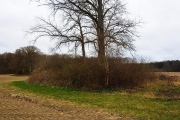
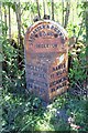
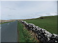
With hindsight I'm delighted to have spotted this one as I cycled past but, not fully trusting my intuition, etc., I took only the one photo from the roadside. The location is good. Being at the highest point in the pass on what we might assume was a major east-west trade / travel route (and later a Roman road), it would once have made a very considerable visual impact.
From Pastscape:
"Cairn said to have been opened about 1800 and contained
'stone coffin and an entire human skeleton'.
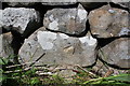
The cairn is approximately 29.0m diameter, and was formerly 1.6m
high. It is extensively mutilated, most of the centre having been
removed, leaving the base, with a few large kerbstones, intact."
Monument no. 44830
You may be viewing yesterday's version of this page. To see the most up to date information please register for a free account.
Do not use the above information on other web sites or publications without permission of the contributor.
Nearby Images from Geograph Britain and Ireland:
©2015(licence)
©2005(licence)
©2022(licence)
©2019(licence)
©2013(licence)
The above images may not be of the site on this page, they are loaded from Geograph.
Please Submit an Image of this site or go out and take one for us!
Click here to see more info for this site
Nearby sites
Key: Red: member's photo, Blue: 3rd party photo, Yellow: other image, Green: no photo - please go there and take one, Grey: site destroyed
Download sites to:
KML (Google Earth)
GPX (GPS waypoints)
CSV (Garmin/Navman)
CSV (Excel)
To unlock full downloads you need to sign up as a Contributory Member. Otherwise downloads are limited to 50 sites.
Turn off the page maps and other distractions
Nearby sites listing. In the following links * = Image available
364m SSE 160° Sleights Pasture Propped Stone* Rock Outcrop (SD7579578018)
805m NE 43° Batty Wife Hole Ring Cairn (SD76227895)
1.0km SW 233° Philpin Sleights* Rock Outcrop (SD7486677760)
1.4km SW 219° Keld Bank (Ingleborough)* Rock Art (SD7475977253)
1.4km SW 225° Keld Bank Settlement* Ancient Village or Settlement (SD74657734)
4.1km SSW 201° Ingleborough Camp* Hillfort (SD7419374511)
4.6km SE 142° Skirtful of Stones (Ingleborough) Cairn (SD785747)
4.8km W 274° Apron Full of Stones* Ring Cairn (SD709787)
5.3km W 277° Yordas cave* Cave or Rock Shelter (SD704790)
5.8km WSW 241° Twisleton Scar Rock Outcrop (SD70597563)
6.0km SW 221° White Scars Cairn (SD717738)
8.4km S 173° Norber Erratics Natural Stone / Erratic / Other Natural Feature (SD76597003)
10.0km NE 50° Old Wife's Spring (Snaizeholme) Holy Well or Sacred Spring (SD834847)
10.8km W 261° Leck Hall* Ancient Village or Settlement (SD64927677)
11.1km W 281° Brownthwaite Pike Round Cairn* Round Cairn (SD6477280479)
11.1km ESE 116° Giant's Graves (Halton Gill) Cairn (SD8564873346)
11.2km ENE 62° Mêni Mabbin Stone Row / Alignment (SD856835)
11.5km SSE 165° Feizor (Lawkland) Standing Stone (Menhir) (SD78586718)
11.6km SSE 159° Feizor Thwaite (Lawkland) Ring Cairn (SD79796747)
11.8km SSE 158° Feizor Celtic Wall* Misc. Earthwork (SD8008067386)
11.8km W 278° Casterton* Stone Circle (SD63937999)
12.6km SSE 157° Feizor Thwaite Propped Stone* Rock Outcrop (SD8057466703)
12.8km SSE 158° Sheep Scar Circle (Giggleswick) Ring Cairn (SD8051366473)
12.9km SSE 157° Sheep Scar Cairn (Giggleswick) Cairn (SD8067866436)
13.1km SSE 157° Apronful of Stones (Giggleswick) Cairn (SD8065266193)
View more nearby sites and additional images


 We would like to know more about this location. Please feel free to add a brief description and any relevant information in your own language.
 Wir möchten mehr über diese Stätte erfahren. Bitte zögern Sie nicht, eine kurze Beschreibung und relevante Informationen in Deutsch hinzuzufügen.
 Nous aimerions en savoir encore un peu sur les lieux. S'il vous plaît n'hesitez pas à ajouter une courte description et tous les renseignements pertinents dans votre propre langue.
 Quisieramos informarnos un poco más de las lugares. No dude en añadir una breve descripción y otros datos relevantes en su propio idioma.