

<< Text Pages >> Dolmen de la Planquette - Burial Chamber or Dolmen in France in Languedoc:Hérault (34)
Submitted by holger_rix on Friday, 18 March 2016 Page Views: 992
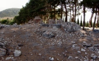
Neolithic and Bronze AgeSite Name: Dolmen de la PlanquetteCountry: France Département: Languedoc:Hérault (34) Type: Burial Chamber or Dolmen
Nearest Town: Lodève Nearest Village: Joncels
Latitude: 43.738300N Longitude: 3.195280E
Condition:
| 5 | Perfect |
| 4 | Almost Perfect |
| 3 | Reasonable but with some damage |
| 2 | Ruined but still recognisable as an ancient site |
| 1 | Pretty much destroyed, possibly visible as crop marks |
| 0 | No data. |
| -1 | Completely destroyed |
| 5 | Superb |
| 4 | Good |
| 3 | Ordinary |
| 2 | Not Good |
| 1 | Awful |
| 0 | No data. |
| 5 | Can be driven to, probably with disabled access |
| 4 | Short walk on a footpath |
| 3 | Requiring a bit more of a walk |
| 2 | A long walk |
| 1 | In the middle of nowhere, a nightmare to find |
| 0 | No data. |
| 5 | co-ordinates taken by GPS or official recorded co-ordinates |
| 4 | co-ordinates scaled from a detailed map |
| 3 | co-ordinates scaled from a bad map |
| 2 | co-ordinates of the nearest village |
| 1 | co-ordinates of the nearest town |
| 0 | no data |
Be the first person to rate this site - see the 'Contribute!' box in the right hand menu.
Internal Links:
External Links:
Burial Chamber (Dolmen) in Languedoc:Hérault (34)
La Fleyssière, Joncels, Lodève, Hérault, Languedoc-Roussillon-Midi-Pyrénées
Some information with picture:
midilibre
"This dolmen, discovered it a few years ago, was the subject of a sondange in 2005 and an excavation in 2006, directed by Anne-Lise RIVER. Publication in the Bulletin of the Archaeological and Historical Society of High Cantons in 34600 BEDARIEUX, No. 29 of 2006.
His position is not released on time as the excavation ends."
Source: T4T35.fr
You may be viewing yesterday's version of this page. To see the most up to date information please register for a free account.
Do not use the above information on other web sites or publications without permission of the contributor.
Nearby sites
Click here to view sites on an interactive map of the areaDownload sites to:
KML (Google Earth)
GPX (GPS waypoints)
CSV (Garmin/Navman)
CSV (Excel)
To unlock full downloads you need to sign up as a Contributory Member. Otherwise downloads are limited to 50 sites.
Nearby sites listing. In the following links * = Image available
2.0km N 350° La Quille menhir Standing Stone (Menhir)
4.8km NW 322° Dolmen de l'Homme Mort (Avène) Burial Chamber or Dolmen
7.3km SE 131° Dolmens du Mas Trinquier* Burial Chamber or Dolmen
7.4km SE 133° Dolmen de Lavalette* Burial Chamber or Dolmen
7.8km ENE 73° Dolmen du Grézac 2 Burial Chamber or Dolmen
8.0km ENE 73° Dolmen du Grézac 1 Burial Chamber or Dolmen
9.0km E 82° Oppidum du Grézac* Ancient Village or Settlement
10.3km E 94° Grotte fermée Cave or Rock Shelter
10.8km SE 124° Dolmen de la Fourille* Burial Chamber or Dolmen
10.9km SE 131° Dolmen dit de Toucou 1 Burial Chamber or Dolmen
10.9km SE 131° Dolmen dit de Toucou 2 Burial Chamber or Dolmen
10.9km ENE 59° Dolmen de Murène Burial Chamber or Dolmen
11.0km SE 132° Toucou Dolmens* Barrow Cemetery
11.0km NNW 344° Dolmen de l'Arbussel Burial Chamber or Dolmen
11.0km SE 132° Dolmen dit de Toucou 6* Burial Chamber or Dolmen
11.0km SE 132° Menhirs de Lacade* Standing Stone (Menhir)
11.1km SE 132° Dolmen dit de Toucou 3* Burial Chamber or Dolmen
11.1km SE 131° Dolmen dit de Toucou 4* Burial Chamber or Dolmen
11.2km SE 131° Dolmen dit de Toucou 5* Burial Chamber or Dolmen
11.2km SE 144° Menhir de Basse* Standing Stone (Menhir)
11.2km ESE 108° Grotte de Tréviols Cave or Rock Shelter
12.0km NE 53° Dolmen de Pégairolles de l'Escalette Burial Chamber or Dolmen
12.4km SE 131° Menhir de Carols Standing Stone (Menhir)
12.9km NNW 335° Dolmen des Claparèdes Burial Chamber or Dolmen
13.0km ENE 69° Dolmen des Coutelles 2* Burial Chamber or Dolmen


 We would like to know more about this location. Please feel free to add a brief description and any relevant information in your own language.
 Wir möchten mehr über diese Stätte erfahren. Bitte zögern Sie nicht, eine kurze Beschreibung und relevante Informationen in Deutsch hinzuzufügen.
 Nous aimerions en savoir encore un peu sur les lieux. S'il vous plaît n'hesitez pas à ajouter une courte description et tous les renseignements pertinents dans votre propre langue.
 Quisieramos informarnos un poco más de las lugares. No dude en añadir una breve descripción y otros datos relevantes en su propio idioma.