<< Text Pages >> Dolmen de Kerhille - Burial Chamber or Dolmen in France in Bretagne:Morbihan (56)
Submitted by holger_rix on Thursday, 25 February 2016 Page Views: 839
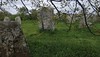
Neolithic and Bronze AgeSite Name: Dolmen de Kerhille Alternative Name: KerhillioCountry: France Département: Bretagne:Morbihan (56) Type: Burial Chamber or Dolmen
Nearest Town: Erdeven Nearest Village: Erdeven
Latitude: 47.642200N Longitude: 3.15444W
Condition:
| 5 | Perfect |
| 4 | Almost Perfect |
| 3 | Reasonable but with some damage |
| 2 | Ruined but still recognisable as an ancient site |
| 1 | Pretty much destroyed, possibly visible as crop marks |
| 0 | No data. |
| -1 | Completely destroyed |
| 5 | Superb |
| 4 | Good |
| 3 | Ordinary |
| 2 | Not Good |
| 1 | Awful |
| 0 | No data. |
| 5 | Can be driven to, probably with disabled access |
| 4 | Short walk on a footpath |
| 3 | Requiring a bit more of a walk |
| 2 | A long walk |
| 1 | In the middle of nowhere, a nightmare to find |
| 0 | No data. |
| 5 | co-ordinates taken by GPS or official recorded co-ordinates |
| 4 | co-ordinates scaled from a detailed map |
| 3 | co-ordinates scaled from a bad map |
| 2 | co-ordinates of the nearest village |
| 1 | co-ordinates of the nearest town |
| 0 | no data |
Be the first person to rate this site - see the 'Contribute!' box in the right hand menu.
Internal Links:
External Links:
Burial Chamber (Dolmen) in Bretagne:Morbihan (56)
Gare routière, Rue du Président René Cassin, Erdeven, Lorient, Morbihan, Brittany
Source: T4T35.fr
You may be viewing yesterday's version of this page. To see the most up to date information please register for a free account.
Do not use the above information on other web sites or publications without permission of the contributor.
Nearby Images from Flickr


The above images may not be of the site on this page, but were taken nearby. They are loaded from Flickr so please click on them for image credits.
Click here to see more info for this site
Nearby sites
Click here to view sites on an interactive map of the areaKey: Red: member's photo, Blue: 3rd party photo, Yellow: other image, Green: no photo - please go there and take one, Grey: site destroyed
Download sites to:
KML (Google Earth)
GPX (GPS waypoints)
CSV (Garmin/Navman)
CSV (Excel)
To unlock full downloads you need to sign up as a Contributory Member. Otherwise downloads are limited to 50 sites.
Turn off the page maps and other distractions
Nearby sites listing. In the following links * = Image available
332m SE 129° Botlann Dolmen* Burial Chamber or Dolmen
797m SE 144° Géants de Kerzerho* Stone Row / Alignment
829m SSE 148° La Table du Sacrifice* Burial Chamber or Dolmen
973m SSE 150° Kerzerho Alignements* Multiple Stone Rows / Avenue
1.0km S 171° Men Glas (Erdeven) Standing Stone (Menhir)
1.1km SE 136° Alignements de Belanno Stone Row / Alignment
1.3km W 263° Alignement dit Mer-er-Morh* Stone Row / Alignment
1.4km SE 129° Kerjean Menhirs* Multiple Stone Rows / Avenue
1.4km W 272° Dolmen de Kerangre* Burial Chamber or Dolmen
1.6km E 101° Menhirs de Keredo Standing Stone (Menhir)
1.6km SW 224° Cairn de Kervazic Runel Chambered Cairn
1.6km SW 234° Menhir de Kerfournic Standing Stone (Menhir)
1.6km SW 214° Touloupry menhir Standing Stone (Menhir)
1.7km SSW 207° Menhirs de Narbon Standing Stones
1.8km N 355° Lann Horou Dolmen Burial Chamber or Dolmen
1.9km ESE 118° Mané Braz tumulus* Chambered Tomb
2.0km ESE 118° Mané Braz menhirs* Standing Stones
2.2km WNW 303° Dolmens des Sept Saints* Burial Chamber or Dolmen
2.3km E 95° Er Run Dolmen* Burial Chamber or Dolmen
2.5km NNW 329° Menhir de Kervenahuel Standing Stone (Menhir)
2.5km N 356° Vilionec Menhir* Standing Stone (Menhir)
2.6km WNW 286° Menhir de Saint-Germain* Standing Stone (Menhir)
2.6km NW 306° Dolmen de Kerihuel* Burial Chamber or Dolmen
2.8km ESE 115° La Chaise de César* Standing Stone (Menhir)
2.8km ESE 115° Coet-ar-Bei* Multiple Stone Rows / Avenue
View more nearby sites and additional images


 We would like to know more about this location. Please feel free to add a brief description and any relevant information in your own language.
 Wir möchten mehr über diese Stätte erfahren. Bitte zögern Sie nicht, eine kurze Beschreibung und relevante Informationen in Deutsch hinzuzufügen.
 Nous aimerions en savoir encore un peu sur les lieux. S'il vous plaît n'hesitez pas à ajouter une courte description et tous les renseignements pertinents dans votre propre langue.
 Quisieramos informarnos un poco más de las lugares. No dude en añadir una breve descripción y otros datos relevantes en su propio idioma.