

<< Our Photo Pages >> Petróglifo de A Nave - Rock Art in Spain in Galicia
Submitted by holger_rix on Friday, 18 December 2015 Page Views: 936
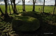
Rock ArtSite Name: Petróglifo de A NaveCountry: Spain Region: Galicia Type: Rock Art
Latitude: 42.848550N Longitude: 8.623796W
Condition:
| 5 | Perfect |
| 4 | Almost Perfect |
| 3 | Reasonable but with some damage |
| 2 | Ruined but still recognisable as an ancient site |
| 1 | Pretty much destroyed, possibly visible as crop marks |
| 0 | No data. |
| -1 | Completely destroyed |
| 5 | Superb |
| 4 | Good |
| 3 | Ordinary |
| 2 | Not Good |
| 1 | Awful |
| 0 | No data. |
| 5 | Can be driven to, probably with disabled access |
| 4 | Short walk on a footpath |
| 3 | Requiring a bit more of a walk |
| 2 | A long walk |
| 1 | In the middle of nowhere, a nightmare to find |
| 0 | No data. |
| 5 | co-ordinates taken by GPS or official recorded co-ordinates |
| 4 | co-ordinates scaled from a detailed map |
| 3 | co-ordinates scaled from a bad map |
| 2 | co-ordinates of the nearest village |
| 1 | co-ordinates of the nearest town |
| 0 | no data |
Be the first person to rate this site - see the 'Contribute!' box in the right hand menu.
Internal Links:
External Links:
")
You may be viewing yesterday's version of this page. To see the most up to date information please register for a free account.
")
")
Do not use the above information on other web sites or publications without permission of the contributor.
Nearby Images from Flickr
The above images may not be of the site on this page, but were taken nearby. They are loaded from Flickr so please click on them for image credits.
Click here to see more info for this site
Nearby sites
Click here to view sites on an interactive map of the areaKey: Red: member's photo, Blue: 3rd party photo, Yellow: other image, Green: no photo - please go there and take one, Grey: site destroyed
Download sites to:
KML (Google Earth)
GPX (GPS waypoints)
CSV (Garmin/Navman)
CSV (Excel)
To unlock full downloads you need to sign up as a Contributory Member. Otherwise downloads are limited to 50 sites.
Turn off the page maps and other distractions
Nearby sites listing. In the following links * = Image available
1.5km NW 311° Castro de Ortoño Castro or Chafurdão
1.9km NNE 18° Castro de Mirás de Arriba Castro or Chafurdão
2.5km NNE 19° Petróglifo de Silvouta* Rock Art
3.2km SSW 199° Petróglifo do Monte Pumariño Rock Art
3.7km N 11° Petróglifo do Rexío* Rock Art
3.8km S 190° Castro Lupario Castro or Chafurdão
4.0km WNW 298° Castro de Lamiño* Castro or Chafurdão
4.1km SE 146° Castro Mouro Castro or Chafurdão
4.2km NNE 24° Castro de Tras Igrexa Castro or Chafurdão
4.4km NNE 23° Petróglifo de Tras Igrexa* Rock Art
4.8km WNW 294° Castro de Froxán Castro or Chafurdão
4.9km N 349° Castro de Castelo ou Ventosa Castro or Chafurdão
4.9km N 358° A Peneda Negra* Rock Art
5.0km ENE 67° Castro de Conxo Castro or Chafurdão
5.0km ENE 68° Castriño de Conxo Petroglifos* Rock Art
5.1km N 351° Petróglifo do Monte Castelo* Rock Art
5.1km SW 230° Castro de Bemil Castro or Chafurdão
5.2km W 259° Castro de Gosende Castro or Chafurdão
5.2km NE 37° Castro de Marmancou Castro or Chafurdão
6.0km SSE 161° Petróglifo de Outeiro do Corno* Rock Art
6.1km WNW 302° Torres de Altamira Castro or Chafurdão
6.3km NE 40° Petroglifos de Correxíns* Rock Art
6.3km W 277° Castro de Tembra Castro or Chafurdão
6.7km N 351° Castro do Monte San Marcos Castro or Chafurdão
6.9km W 271° Castro de Boullón Castro or Chafurdão
View more nearby sites and additional images


 We would like to know more about this location. Please feel free to add a brief description and any relevant information in your own language.
 Wir möchten mehr über diese Stätte erfahren. Bitte zögern Sie nicht, eine kurze Beschreibung und relevante Informationen in Deutsch hinzuzufügen.
 Nous aimerions en savoir encore un peu sur les lieux. S'il vous plaît n'hesitez pas à ajouter une courte description et tous les renseignements pertinents dans votre propre langue.
 Quisieramos informarnos un poco más de las lugares. No dude en añadir una breve descripción y otros datos relevantes en su propio idioma.