

<< Other Photo Pages >> Great Salbyk Kurgan - Pyramid / Mastaba in Russia
Submitted by AlexAssa on Sunday, 29 November 2015 Page Views: 7624
Multi-periodSite Name: Great Salbyk Kurgan Alternative Name: Main monument of the Valley of the Kings, Bol'shoy Salbykskiy, Большой Салбыкский КурганCountry: Russia Type: Pyramid / Mastaba
Nearest Town: Abakan Nearest Village: Vershino-Bija
Latitude: 53.894259N Longitude: 90.773752E
Condition:
| 5 | Perfect |
| 4 | Almost Perfect |
| 3 | Reasonable but with some damage |
| 2 | Ruined but still recognisable as an ancient site |
| 1 | Pretty much destroyed, possibly visible as crop marks |
| 0 | No data. |
| -1 | Completely destroyed |
| 5 | Superb |
| 4 | Good |
| 3 | Ordinary |
| 2 | Not Good |
| 1 | Awful |
| 0 | No data. |
| 5 | Can be driven to, probably with disabled access |
| 4 | Short walk on a footpath |
| 3 | Requiring a bit more of a walk |
| 2 | A long walk |
| 1 | In the middle of nowhere, a nightmare to find |
| 0 | No data. |
| 5 | co-ordinates taken by GPS or official recorded co-ordinates |
| 4 | co-ordinates scaled from a detailed map |
| 3 | co-ordinates scaled from a bad map |
| 2 | co-ordinates of the nearest village |
| 1 | co-ordinates of the nearest town |
| 0 | no data |
Internal Links:
External Links:
I have visited· I would like to visit
DrewParsons would like to visit
")
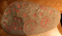
The mound is a stone square (70 * 70 m) from huge slabs of the Devonian sandstone (weighing 50-70 tons) delivered over a hundred kilometers from the banks of the Yenisei River. It is believed that it was an ancient temple, and Astronomical Observatory (showing the movement of the Sun and the Moon). Still remains a mystery what devices used for the importation and installation of these stones. At the corners and sides of the stone fences were enough driven large menhirs, all 23 stone up to a height of 6 meters (everyone brings their energy).
Before the construction of a giant earth embankment inside the stone fence was a crypt of logs in the form of a truncated pyramid. This whole crypt inside and outside covered with a thick layer of bark. The crypt had the height of 2.5 m and a depth of two metros of water covered pit.
It is claimed that around the burial zone has long been observed a strong anomaly, the study of these phenomena have engaged scholars.
You may be viewing yesterday's version of this page. To see the most up to date information please register for a free account.
")
")
")
")
")
")
")
Do not use the above information on other web sites or publications without permission of the contributor.
Click here to see more info for this site
Nearby sites
Click here to view sites on an interactive map of the areaKey: Red: member's photo, Blue: 3rd party photo, Yellow: other image, Green: no photo - please go there and take one, Grey: site destroyed
Download sites to:
KML (Google Earth)
GPX (GPS waypoints)
CSV (Garmin/Navman)
CSV (Excel)
To unlock full downloads you need to sign up as a Contributory Member. Otherwise downloads are limited to 50 sites.
Turn off the page maps and other distractions
Nearby sites listing. In the following links * = Image available
47.9km ESE 114° Museum Kyzlasov L.R.* Museum
78.8km NW 317° Tuim Cromlech* Stone Circle
104.1km WNW 304° Paleolithic settlement Small Syya* Ancient Village or Settlement
111.7km NW 324° Complex Sunduki* Natural Stone / Erratic / Other Natural Feature
267.2km NNE 28° Settlement Afontova Mountain* Ancient Village or Settlement
270.5km NNE 29° Krasnoyarsk Regional Museum of Local Lore* Museum
276.6km SSE 156° Ancient sanctuary Chaa-Holl* Rock Cut Tomb
280.4km SE 134° Arzhan Scythian royal necropolis* Barrow Cemetery
344.7km SE 133° Republican Museum of Kyzyl* Museum
386.1km WSW 239° Mayma VI Barrow Cemetery
388.6km WSW 238° Anokhin Museum* Museum
389.9km WSW 237° Oldest settlement Ulalinka* Ancient Village or Settlement
455.9km SW 232° Tavdinsky Caves Cave or Rock Shelter
469.9km SW 216° Chuya Deer Stone* Standing Stone (Menhir)
472.8km SW 216° Kalbak-Tash* Rock Art
474.9km SW 226° Tuekta kurgan* Artificial Mound
477.6km SW 218° Inya Deer Stones* Standing Stone (Menhir)
481.5km SSW 200° Tarhatinsky megalithic site* Standing Stones
496.0km WSW 238° Denisova* Cave or Rock Shelter
497.7km WSW 240° Karama - Paleolithic settlement* Ancient Village or Settlement
559.6km SSW 199° Shiveet Mountain Petroglyphs* Rock Art
559.7km SSW 199° Mt. Shiveet altar stone with petroglyphs* Rock Art
590.2km SSW 213° Berel Burial Mounds* Barrow Cemetery
607.5km SSW 197° Lake Hoton Round Barrow Round Barrow(s)
607.8km SSW 197° Lake Hoton Petroglyphs* Rock Art
View more nearby sites and additional images


 We would like to know more about this location. Please feel free to add a brief description and any relevant information in your own language.
 Wir möchten mehr über diese Stätte erfahren. Bitte zögern Sie nicht, eine kurze Beschreibung und relevante Informationen in Deutsch hinzuzufügen.
 Nous aimerions en savoir encore un peu sur les lieux. S'il vous plaît n'hesitez pas à ajouter une courte description et tous les renseignements pertinents dans votre propre langue.
 Quisieramos informarnos un poco más de las lugares. No dude en añadir una breve descripción y otros datos relevantes en su propio idioma.