<< Our Photo Pages >> Großsteingrab im Sandheck - Chambered Tomb in Germany in North Rhine-Westphalia
Submitted by Harald_Platta on Wednesday, 17 June 2015 Page Views: 1922
Neolithic and Bronze AgeSite Name: Großsteingrab im Sandheck Alternative Name: die hilligen Kämpe, Kleine Kämpchen, Großsteingrab Groß RekenCountry: Germany Land: North Rhine-Westphalia Type: Chambered Tomb
Nearest Town: Borken Nearest Village: Reken
Latitude: 51.835719N Longitude: 7.094407E
Condition:
| 5 | Perfect |
| 4 | Almost Perfect |
| 3 | Reasonable but with some damage |
| 2 | Ruined but still recognisable as an ancient site |
| 1 | Pretty much destroyed, possibly visible as crop marks |
| 0 | No data. |
| -1 | Completely destroyed |
| 5 | Superb |
| 4 | Good |
| 3 | Ordinary |
| 2 | Not Good |
| 1 | Awful |
| 0 | No data. |
| 5 | Can be driven to, probably with disabled access |
| 4 | Short walk on a footpath |
| 3 | Requiring a bit more of a walk |
| 2 | A long walk |
| 1 | In the middle of nowhere, a nightmare to find |
| 0 | No data. |
| 5 | co-ordinates taken by GPS or official recorded co-ordinates |
| 4 | co-ordinates scaled from a detailed map |
| 3 | co-ordinates scaled from a bad map |
| 2 | co-ordinates of the nearest village |
| 1 | co-ordinates of the nearest town |
| 0 | no data |
Internal Links:
External Links:
I have visited· I would like to visit
Harald_Platta visited on 1st Oct 2015 - their rating: Cond: 1 Amb: 3 Access: 4

Back then, visitors compared Sandheck with the nearby Düvelsteene in Heiden.
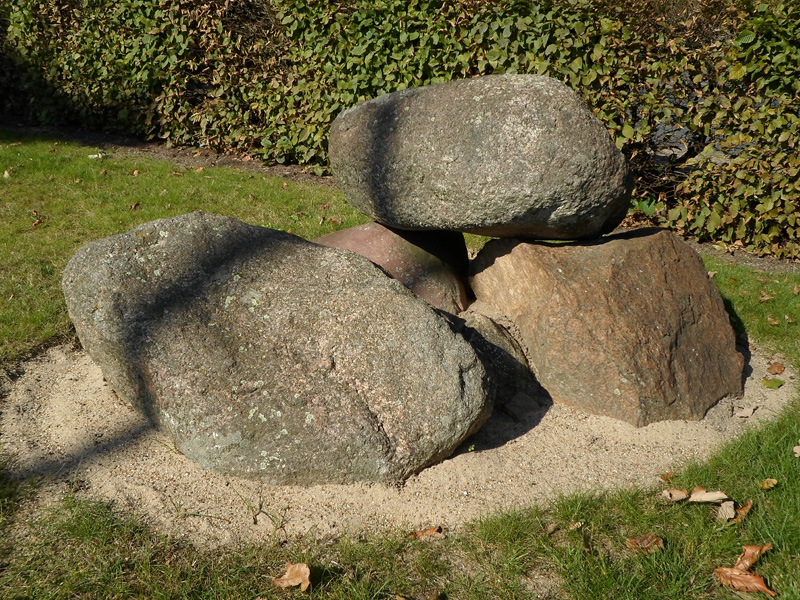
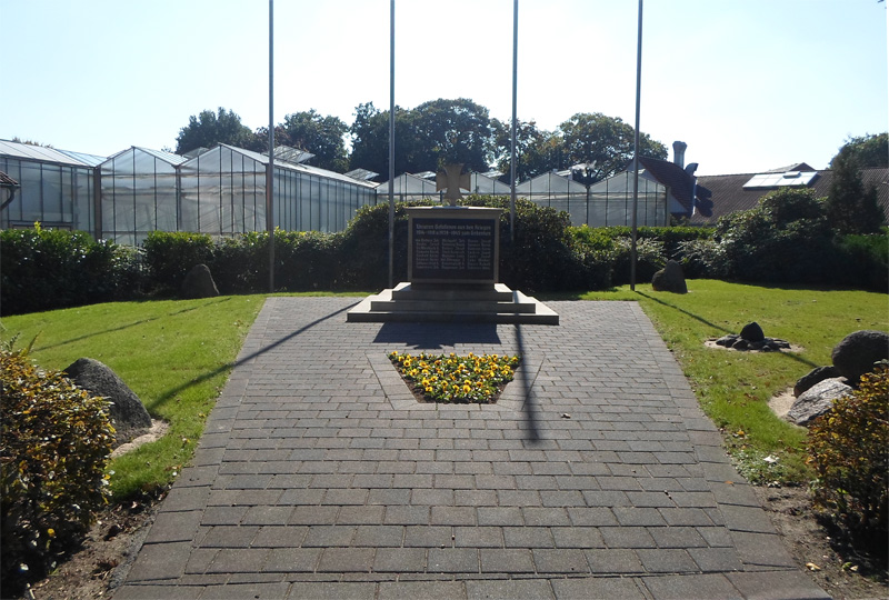
While the exact position of the tomb was forgotten for a long time, a re-examination in the year 2009 suggested the localization in a field near Sandheck street (coordinates: 51.843038, 7.073408). Some of the stones of the chambered tomb had been recovered before, when an sheep barn, which was located 1 km north-east of the tomb, was teared down. They were re-used as decoration of the war memorial in the nearby village Maria-Veen in 1952. More parts of the former tomb were recovered, when another house was teared down in 2006. The stones can still be seen at the war memorial (see coordinates at the top of the page). The site interconnects the remains of the megalithic tomb and the modern memorial stone for the remembrance of the dead.
The single remaining find from the tomb is a clay pott called Kragenflasche von Reken, which stems from the Funnelbeaker Culture. It is 10 cm high and displays a sharp profile. Moreover, it is decorated with vertically downwards extending recesses. The find was of certain significance because it was one of the first described clay pots of this type.
A similar clay pot has been found in the nearby Düvelsteene. While the Kragenflasche of the Düvelsteene can be seen in the Museum Ramsdorf, the Kragenflasche von Reken is stored in the depot of the LWL-Archäologie - Außenstelle Münster.
It has been suggested, that the Kragenflasche might have had a content of ritual meaning, like e.g. precious oil or brimstone, that have also been found in other Kragenflaschen. Alternatively, it might have contained water or another drink as grave good for the journey of the dead.
Literature:
[01] Tenbohlen, H. & Sondermann, J.: Archäologische Fundstücke aus der Vorzeit im Rekener Raum (2009).
[02] Knöll, H.: Kragenflaschen. Ihre Verbreitung und ihre Zeitstellung im europäischen Neolithikum. In: Offa Bücher 41 (1981).
[03] Sprockhoff, E.: Atlas der Megalithgräber Niedersachsens u. Westfalens (1975).
[04] Heselhaus, A.: Bodenforschung im Kreise Borken (1974).
[05] Knöll, H.: Nordwestdeutsche Tiefstichkeramik (1959).
[06] Obertkirch, K.: Kreisstelle für Naturdenkmalpflege Tgb.Nr.214/30. (1930).
[07] Aberg, N.: New Stone Age in Northern und Western Europe (1912).
You may be viewing yesterday's version of this page. To see the most up to date information please register for a free account.


Do not use the above information on other web sites or publications without permission of the contributor.
Click here to see more info for this site
Nearby sites
Click here to view sites on an interactive map of the areaKey: Red: member's photo, Blue: 3rd party photo, Yellow: other image, Green: no photo - please go there and take one, Grey: site destroyed
Download sites to:
KML (Google Earth)
GPX (GPS waypoints)
CSV (Garmin/Navman)
CSV (Excel)
To unlock full downloads you need to sign up as a Contributory Member. Otherwise downloads are limited to 50 sites.
Turn off the page maps and other distractions
Nearby sites listing. In the following links * = Image available
930m W 269° Reken Grabhügel 4108/32* Round Barrow(s)
1.8km WNW 294° Reken Grabhügel 4108/30* Round Barrow(s)
1.9km S 185° Reken Grabhügel 4108/25 Round Barrow(s)
2.0km WNW 295° Reken Grabhügel 4108/10* Round Barrow(s)
2.1km WNW 294° Reken Grabhügel 4108/31* Round Barrow(s)
2.1km WNW 292° Reken Grabhügel 4108/35* Round Barrow(s)
2.4km S 186° Reken Grabhügel 4108/26 Round Barrow(s)
2.5km SSE 147° Reken Grabhügel 4108/13 Round Barrow(s)
2.8km SSE 152° Reken Grabhügel 4108/14 Round Barrow(s)
3.2km S 190° Grabhügelfeld Wildgrund Barrow Cemetery
3.3km SSE 155° Radberg* Barrow Cemetery
3.6km SSE 160° Reken Grabhügel 4108/18 Round Barrow(s)
3.7km SSE 149° Reken Grabhügel 4108/27 Round Barrow(s)
3.8km SSE 162° Reken Grabhügel 4108/22 Round Barrow(s)
4.6km NE 36° Grabhügel, Mkz. 4108,39* Round Barrow(s)
4.6km W 277° Reken Grabhügelgruppe 4108/21a-d* Barrow Cemetery
5.0km S 189° Reken Huelsterholt Huegelgrab* Round Barrow(s)
5.0km W 274° Reken Grabhügel 4108/38 Round Barrow(s)
5.2km W 279° Reken Grabhügelgruppe 4108/36a-j Barrow Cemetery
5.2km W 278° Reken Grabhügel 4108/37* Round Barrow(s)
5.9km NE 35° Grabhügel, Mkz. 4108,16 und 4108,17 Round Barrow(s)
7.6km NNE 17° Grabhügel, Mkz. 4008,30 und 4008,31 Round Barrow(s)
8.0km W 268° Düwelsteene* Chambered Tomb
8.2km NNE 19° Grabhügel, Mkz. 4008, 3* Round Barrow(s)
8.3km WSW 253° Tho Sollynck* Natural Stone / Erratic / Other Natural Feature
View more nearby sites and additional images


 We would like to know more about this location. Please feel free to add a brief description and any relevant information in your own language.
 Wir möchten mehr über diese Stätte erfahren. Bitte zögern Sie nicht, eine kurze Beschreibung und relevante Informationen in Deutsch hinzuzufügen.
 Nous aimerions en savoir encore un peu sur les lieux. S'il vous plaît n'hesitez pas à ajouter une courte description et tous les renseignements pertinents dans votre propre langue.
 Quisieramos informarnos un poco más de las lugares. No dude en añadir una breve descripción y otros datos relevantes en su propio idioma.