


<< Our Photo Pages >> Foster Clough - Misc. Earthwork in England in Yorkshire (West)
Submitted by NorthernerInLondon on Wednesday, 14 January 2015 Page Views: 3310
Date UncertainSite Name: Foster CloughCountry: England County: Yorkshire (West) Type: Misc. Earthwork
Nearest Town: Mytholmyroyd Nearest Village: Midgley
Map Ref: SE02352708
Latitude: 53.740098N Longitude: 1.965851W
Condition:
| 5 | Perfect |
| 4 | Almost Perfect |
| 3 | Reasonable but with some damage |
| 2 | Ruined but still recognisable as an ancient site |
| 1 | Pretty much destroyed, possibly visible as crop marks |
| 0 | No data. |
| -1 | Completely destroyed |
| 5 | Superb |
| 4 | Good |
| 3 | Ordinary |
| 2 | Not Good |
| 1 | Awful |
| 0 | No data. |
| 5 | Can be driven to, probably with disabled access |
| 4 | Short walk on a footpath |
| 3 | Requiring a bit more of a walk |
| 2 | A long walk |
| 1 | In the middle of nowhere, a nightmare to find |
| 0 | No data. |
| 5 | co-ordinates taken by GPS or official recorded co-ordinates |
| 4 | co-ordinates scaled from a detailed map |
| 3 | co-ordinates scaled from a bad map |
| 2 | co-ordinates of the nearest village |
| 1 | co-ordinates of the nearest town |
| 0 | no data |
Internal Links:
External Links:
I have visited· I would like to visit
NorthernerInLondon visited - their rating: Cond: 3 Amb: 4 Access: 3
")
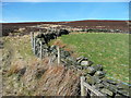
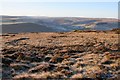
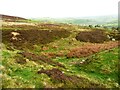
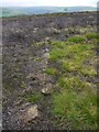
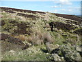
Unexcavated circular earthworks on Midgley moor. Very close to both Miller's Grave and the Wicken Hill enclosure. Date uncertain.
This site is recorded as Pastscape Monument No 1454496, which says: "A circular ditch of uncertain function or date is visible as an earthwork on the south-west fringe of Midgely Moor. The circle is approximately 22 metres in diameter and has a slight upcast exterior bank. Located concentrically within the circle is a second circle, of approximately 10 metres diameter, defined by a very slight ditch. The outer ditch is quite clean cut and incised which may indicate a more recent origin."
The Northern Antiquarian (TNA) also feature a page on this site - see their entry for Foster Clough Delph, Midgley Moor, West Yorkshire which has directions for finding this site together with photographs, aerial images and a brief archaeology & history.
You may be viewing yesterday's version of this page. To see the most up to date information please register for a free account.
")
Do not use the above information on other web sites or publications without permission of the contributor.
Nearby Images from Geograph Britain and Ireland:
©2015(licence)
©2005(licence)
©2022(licence)
©2012(licence)
©2015(licence)
The above images may not be of the site on this page, they are loaded from Geograph.
Please Submit an Image of this site or go out and take one for us!
Click here to see more info for this site
Nearby sites
Key: Red: member's photo, Blue: 3rd party photo, Yellow: other image, Green: no photo - please go there and take one, Grey: site destroyed
Download sites to:
KML (Google Earth)
GPX (GPS waypoints)
CSV (Garmin/Navman)
CSV (Excel)
To unlock full downloads you need to sign up as a Contributory Member. Otherwise downloads are limited to 50 sites.
Turn off the page maps and other distractions
Nearby sites listing. In the following links * = Image available
250m E 85° Crow Hill Cairn Circle* Stone Circle (SE026271)
522m ENE 70° Midgley Moor Ring Cairn (SE0284227259)
717m NNW 328° Churn Milk Joan (Midgley Moor)* Standing Stone (Menhir) (SE0197327691)
1.1km WNW 287° Wicken Hill* Misc. Earthwork (SE0133527390)
1.4km NNW 341° Miller's Grave* Cairn (SE0191328369)
1.5km WNW 286° Mount Skip (Hebden Bridge) Cairn (SE00952748)
1.6km NNW 334° Greenwood Stone (Midgley Moor)* Marker Stone (SE0165228514)
2.2km NE 53° The White Stones Natural Stone / Erratic / Other Natural Feature (SE041284)
2.6km NNE 29° Sleepy Lowe Cairn (SE03612936)
2.7km S 178° Sowerby Lad (Mytholmroyd) Standing Stone (Menhir) (SE02442443)
2.8km NE 55° Robin Hood's Penny Stone (Wainstalls) Standing Stone (Menhir) (SE04632870)
2.8km E 94° Tower Hill Enclosure Misc. Earthwork (SE05192689)
3.1km NNW 344° Shore End Top Standing Stone (Menhir) (SE01533002)
3.3km ESE 109° Tower Hill (Warley) Cairn (SE05472604)
3.3km NNE 19° Rocking Stone (Warley Moor) Natural Stone / Erratic / Other Natural Feature (SE0339930199)
3.7km NNW 337° High Brown Knoll* Rock Art (SE0089930463)
3.7km N 5° Dean Head Stony Edge* Rock Art (SE0267730808)
4.0km SSW 212° Upper Lumb Cup & Ring Stone Rock Art (SE002237)
4.2km ESE 117° Warley Edge (Halifax)* Rock Art (SE061252)
4.3km NE 48° The Carrs (Ovenden) Ancient Village or Settlement (SE0554729937)
4.3km WNW 293° Dawson City field* Standing Stone (Menhir) (SD9837428800)
4.3km NNW 339° White Hill (Yorkshire West) Rock Art (SE0077031129)
4.5km NNW 334° Clattering Edge* Rock Art (SE0036731145)
4.6km WSW 253° Edge End Moor* Standing Stones (SD97962572)
4.6km SW 222° Rudstoop* Standing Stone (Menhir) (SD9926923652)
View more nearby sites and additional images


 We would like to know more about this location. Please feel free to add a brief description and any relevant information in your own language.
 Wir möchten mehr über diese Stätte erfahren. Bitte zögern Sie nicht, eine kurze Beschreibung und relevante Informationen in Deutsch hinzuzufügen.
 Nous aimerions en savoir encore un peu sur les lieux. S'il vous plaît n'hesitez pas à ajouter une courte description et tous les renseignements pertinents dans votre propre langue.
 Quisieramos informarnos un poco más de las lugares. No dude en añadir una breve descripción y otros datos relevantes en su propio idioma.