

<< Our Photo Pages >> Dolmen de la Pointe du Scal - Burial Chamber or Dolmen in France in Bretagne:Morbihan (56)
Submitted by theCaptain on Monday, 24 November 2014 Page Views: 1489
Neolithic and Bronze AgeSite Name: Dolmen de la Pointe du ScalCountry: France Département: Bretagne:Morbihan (56) Type: Burial Chamber or Dolmen
Nearest Town: Guérande Nearest Village: Trehiguier
Latitude: 47.493010N Longitude: 2.4471W
Condition:
| 5 | Perfect |
| 4 | Almost Perfect |
| 3 | Reasonable but with some damage |
| 2 | Ruined but still recognisable as an ancient site |
| 1 | Pretty much destroyed, possibly visible as crop marks |
| 0 | No data. |
| -1 | Completely destroyed |
| 5 | Superb |
| 4 | Good |
| 3 | Ordinary |
| 2 | Not Good |
| 1 | Awful |
| 0 | No data. |
| 5 | Can be driven to, probably with disabled access |
| 4 | Short walk on a footpath |
| 3 | Requiring a bit more of a walk |
| 2 | A long walk |
| 1 | In the middle of nowhere, a nightmare to find |
| 0 | No data. |
| 5 | co-ordinates taken by GPS or official recorded co-ordinates |
| 4 | co-ordinates scaled from a detailed map |
| 3 | co-ordinates scaled from a bad map |
| 2 | co-ordinates of the nearest village |
| 1 | co-ordinates of the nearest town |
| 0 | no data |
Internal Links:
External Links:
I have visited· I would like to visit
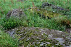
TheCaptain visited on 10th Jun 2005 - their rating: Cond: 2 Amb: 3 Access: 4 This site, nearby the Pierre Blanche, is now marked by the ign as a seperate burial chamber besides the Pierre Blanche menhir.
Trehiguier menhir, La Pierre Blanche, is a large white quartz block found down Allée de Megalithe, and at the left just before the end of the road at a boatyard, or fish factory. It is about 2.5 metres high, and 1.5 metres square at the base. About 10 metres away is a large grey slab with some holes, and many other stones which are the remains of megalithic tomb of some kind.
")
Trehiguier menhir, La Pierre Blanche, is a large white quartz block found down Allée de Megalithe, and at the left just before the end of the road at a boatyard, or fish factory. It is about 2.5 metres high, and 1.5 metres square at the base.
About 10 metres away is a large grey slab with some holes, and many other stones which are the remains of megalithic tomb of some kind.
You may be viewing yesterday's version of this page. To see the most up to date information please register for a free account.
")
")
")
Do not use the above information on other web sites or publications without permission of the contributor.
Nearby Images from Flickr


The above images may not be of the site on this page, but were taken nearby. They are loaded from Flickr so please click on them for image credits.
Click here to see more info for this site
Nearby sites
Click here to view sites on an interactive map of the areaKey: Red: member's photo, Blue: 3rd party photo, Yellow: other image, Green: no photo - please go there and take one, Grey: site destroyed
Download sites to:
KML (Google Earth)
GPX (GPS waypoints)
CSV (Garmin/Navman)
CSV (Excel)
To unlock full downloads you need to sign up as a Contributory Member. Otherwise downloads are limited to 50 sites.
Turn off the page maps and other distractions
Nearby sites listing. In the following links * = Image available
10m N 0° La Pierre Blanche (Trehiguier)* Standing Stone (Menhir)
3.4km W 270° Dolmen de Méarzenne Burial Chamber or Dolmen
3.4km W 270° Menhir du Halguen* Standing Stone (Menhir)
3.7km NW 311° Dolmen du Crapaud* Burial Chamber or Dolmen
3.7km W 261° Pointe de Cofréneau cairn Cairn
4.2km NW 309° Dolmens des Grays* Burial Chamber or Dolmen
10.2km WNW 301° Menhir du Bois (Ambon) Standing Stone (Menhir)
11.1km SSW 195° Allée Couverte de Kerallement Passage Grave
11.1km NW 313° Dolmen de Kergloanec Burial Chamber or Dolmen
13.5km SE 142° La Pierre De Len Menhir* Standing Stone (Menhir)
13.9km NW 322° Dolmen de Rangliac* Burial Chamber or Dolmen
14.2km ESE 104° Dolmen Du Riholo* Burial Chamber or Dolmen
14.3km SSW 194° Dolmen de Ker Trelan Burial Chamber or Dolmen
14.4km NW 321° Dolmens de Talhouët Burial Chamber or Dolmen
14.5km SSW 201° Dolmen de Kervaudu Burial Chamber or Dolmen
14.6km SSW 210° Pierres du Meniscoul Rock Art
14.9km SSE 154° Pont de Gras* Ancient Trackway
15.2km SSE 148° Keralio Croix Menhir* Standing Stone (Menhir)
15.4km ENE 58° Dolmen dit le Tombeau des Martyrs Burial Chamber or Dolmen
15.4km SSE 158° La Pierre Blanche (Kerbourg)* Standing Stone (Menhir)
15.6km SSW 200° Allée Couverte de Brandu Passage Grave
15.7km NW 309° Menhirs de Bergard* Standing Stones
15.8km SSE 156° Kerbourg Dolmen 1* Passage Grave
15.9km SSE 156° Kerbourg Dolmen 2* Burial Chamber or Dolmen
15.9km NE 55° Dolmen dit La Chambrette Burial Chamber or Dolmen
View more nearby sites and additional images


 We would like to know more about this location. Please feel free to add a brief description and any relevant information in your own language.
 Wir möchten mehr über diese Stätte erfahren. Bitte zögern Sie nicht, eine kurze Beschreibung und relevante Informationen in Deutsch hinzuzufügen.
 Nous aimerions en savoir encore un peu sur les lieux. S'il vous plaît n'hesitez pas à ajouter une courte description et tous les renseignements pertinents dans votre propre langue.
 Quisieramos informarnos un poco más de las lugares. No dude en añadir una breve descripción y otros datos relevantes en su propio idioma.