

<< Our Photo Pages >> Mounds (Indiana) - Henge in United States in Great Lakes Midwest
Submitted by bat400 on Tuesday, 31 March 2015 Page Views: 4625
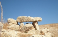
Site WatchSite Name: Mounds (Indiana) Alternative Name: Anderson Mounds, Mounds State ParkCountry: United States Region: Great Lakes Midwest Type: Henge
Nearest Town: Anderson, IN
Latitude: 40.095900N Longitude: 85.62W
Condition:
| 5 | Perfect |
| 4 | Almost Perfect |
| 3 | Reasonable but with some damage |
| 2 | Ruined but still recognisable as an ancient site |
| 1 | Pretty much destroyed, possibly visible as crop marks |
| 0 | No data. |
| -1 | Completely destroyed |
| 5 | Superb |
| 4 | Good |
| 3 | Ordinary |
| 2 | Not Good |
| 1 | Awful |
| 0 | No data. |
| 5 | Can be driven to, probably with disabled access |
| 4 | Short walk on a footpath |
| 3 | Requiring a bit more of a walk |
| 2 | A long walk |
| 1 | In the middle of nowhere, a nightmare to find |
| 0 | No data. |
| 5 | co-ordinates taken by GPS or official recorded co-ordinates |
| 4 | co-ordinates scaled from a detailed map |
| 3 | co-ordinates scaled from a bad map |
| 2 | co-ordinates of the nearest village |
| 1 | co-ordinates of the nearest town |
| 0 | no data |
Internal Links:
External Links:
 - Great Mound (PID:25370)")
The cultural affiliations assigned have included Adena and Hopewell. Excavations show some of the original structures to have been prepared clay floors and low platforms and assemblies of posts. Embankments and mounds were created starting about 90 years later.
Much of the site remains, including the 285 foot long Circle Mound and the 384 foot diameter Great Mound. Even some much eroded and reduced earthworks have been mapped and can be found during early spring before the ground cover foliage is out.
The majority of the mounds are situated on a terrace 50 - 60 feet above the White River. Considering the exploitation of the site as an amusement park at the turn of the 20th century, it is surprising that any of the site remains. The state of Indiana manages the mounds and lush second growth woodland as a State Park. The location listed is for the small visitors center. Walking trails and interpretive signage.
National Register of Historic Places listing added 1973 - - #73000022.
Historic Significance: Information Potential
Area of Significance: Prehistoric
Cultural Affiliation: Middle Woodland
Period of Significance: 499-0 BC, 499-0 AD
Owner: State
Historic Function: Religion
Historic Sub-function: Ceremonial Site
Current Function: Landscape
Current Sub-function: Park
Note: Environmental groups in Indiana resolve to oppose the construction of the dam and reservoir. Delaware County commissioners and county council due to vote on the project in April so hopefully some pressure can be brought to bear - more details in the comments below on how to get involved
You may be viewing yesterday's version of this page. To see the most up to date information please register for a free account.
 - Circle Mound (PID:36604)")
 - Circle Mound (PID:265703)")
 - Circle Mound (PID:265659)")
 - Circle Mound (PID:265658)")
 - Circle Mound (PID:265657)")
 - Circle Mound (PID:265656)")
 - Earthwork D (PID:265624)")
 - Earthwork D (PID:265623)")
 - Fiddleback Mound (PID:265619)")
 - Fiddleback Mound (PID:265618)")
 - Earthwork B (PID:265617)")
 - Earthwork B (PID:265616)")
 - Great Mound (PID:265591)")
 - Great Mound (PID:265590)")
 - Great Mound (PID:265589)")
 - Great Mound (PID:265588)")
 - Great Mound (PID:265587)")
 - Great Mound (PID:262089)")
 - Fiddleback Mound (PID:102365)")
 - Great Mound (PID:68429)")
 - Great Mound (PID:68428)")
 - Great Mound (PID:68427)")
 - Great Mound (PID:68424)")
 - Great Mound (PID:68423)")
 - Circle Mound (PID:25364)")
These are just the first 25 photos of Mounds (Indiana). If you log in with a free user account you will be able to see our entire collection.
Do not use the above information on other web sites or publications without permission of the contributor.
Click here to see more info for this site
Nearby sites
Click here to view sites on an interactive map of the areaKey: Red: member's photo, Blue: 3rd party photo, Yellow: other image, Green: no photo - please go there and take one, Grey: site destroyed
Download sites to:
KML (Google Earth)
GPX (GPS waypoints)
CSV (Garmin/Navman)
CSV (Excel)
To unlock full downloads you need to sign up as a Contributory Member. Otherwise downloads are limited to 50 sites.
Turn off the page maps and other distractions
Nearby sites listing. In the following links * = Image available
277m SW 233° Mounds (Indiana) - Great Mound* Henge
289m SW 216° Mounds (Indiana) - Earthwork B* Misc. Earthwork
311m WSW 245° Mounds (Indiana) - Fiddleback Mound* Misc. Earthwork
406m SW 234° Mounds State Park (Indiana) - Earthwork D* Misc. Earthwork
783m N 6° Mounds (Indiana) - Circle Mound* Misc. Earthwork
15.9km NE 54° Yorktown Enclosure Misc. Earthwork
27.0km ESE 121° New Castle Complex* Henge
28.3km W 278° Castor Farm Ancient Village or Settlement
28.4km W 277° Strawtown Enclosure* Ancient Village or Settlement
29.2km SE 134° Chrysler Enclosure* Henge
35.8km E 79° Windsor Mound* Artificial Mound
48.2km SE 127° Cambridge City Henge Complex* Henge
59.3km SW 232° Indiana State Museum* Museum
69.3km ESE 104° Whitehead Mound* Artificial Mound
94.3km SW 225° Blue Bluff Rock Outcrop
102.0km SW 224° Bundy-Voyles Site* Ancient Village or Settlement
103.6km SE 135° Enyart Mound* Artificial Mound
103.8km SE 135° Reily Cemetery Mound* Artificial Mound
119.8km SE 133° Fortified Hill Works* Hillfort
121.4km SE 137° Dunlap Works* Artificial Mound
122.4km SE 128° Rentschler Park Hilltop Enclosure* Hillfort
125.7km ESE 114° Miamisburg Mound* Artificial Mound
125.7km ESE 109° Sunwatch* Ancient Village or Settlement
127.7km ESE 108° Calvary Cemetery Hilltop Enclosure* Hillfort
128.0km SE 145° Conrad Mound* Artificial Mound
View more nearby sites and additional images


 We would like to know more about this location. Please feel free to add a brief description and any relevant information in your own language.
 Wir möchten mehr über diese Stätte erfahren. Bitte zögern Sie nicht, eine kurze Beschreibung und relevante Informationen in Deutsch hinzuzufügen.
 Nous aimerions en savoir encore un peu sur les lieux. S'il vous plaît n'hesitez pas à ajouter une courte description et tous les renseignements pertinents dans votre propre langue.
 Quisieramos informarnos un poco más de las lugares. No dude en añadir una breve descripción y otros datos relevantes en su propio idioma.