 with our Megalithic Portal iPhone app")

<< Our Photo Pages >> Corodda Nuraghe - Broch or Nuraghe in Italy in Sardinia (Sardegna)
Submitted by SolarMegalith on Thursday, 01 May 2014 Page Views: 1346
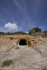
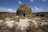
Neolithic and Bronze AgeSite Name: Corodda Nuraghe Alternative Name: Nuraghe CoroddaCountry: Italy Region: Sardinia (Sardegna) Type: Broch or Nuraghe
Nearest Town: Oniferi
Latitude: 40.290489N Longitude: 9.176910E
Condition:
| 5 | Perfect |
| 4 | Almost Perfect |
| 3 | Reasonable but with some damage |
| 2 | Ruined but still recognisable as an ancient site |
| 1 | Pretty much destroyed, possibly visible as crop marks |
| 0 | No data. |
| -1 | Completely destroyed |
| 5 | Superb |
| 4 | Good |
| 3 | Ordinary |
| 2 | Not Good |
| 1 | Awful |
| 0 | No data. |
| 5 | Can be driven to, probably with disabled access |
| 4 | Short walk on a footpath |
| 3 | Requiring a bit more of a walk |
| 2 | A long walk |
| 1 | In the middle of nowhere, a nightmare to find |
| 0 | No data. |
| 5 | co-ordinates taken by GPS or official recorded co-ordinates |
| 4 | co-ordinates scaled from a detailed map |
| 3 | co-ordinates scaled from a bad map |
| 2 | co-ordinates of the nearest village |
| 1 | co-ordinates of the nearest town |
| 0 | no data |
Internal Links:
External Links:
I have visited· I would like to visit
SolarMegalith visited on 18th Apr 2014 - their rating: Cond: 3 Amb: 4 Access: 4
")
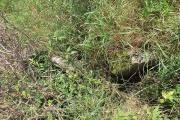
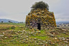
This typical single-towered Middle Bronze Age nuraghe is partly damaged, but its outline is perfectly distinguishable. The tholos chamber survived up to 2m of height, in its walls there are two niches. The entrance opens to the south.
You may be viewing yesterday's version of this page. To see the most up to date information please register for a free account.
")
")
")
Do not use the above information on other web sites or publications without permission of the contributor.
Nearby Images from Flickr

The above images may not be of the site on this page, but were taken nearby. They are loaded from Flickr so please click on them for image credits.
Click here to see more info for this site
Nearby sites
Click here to view sites on an interactive map of the areaKey: Red: member's photo, Blue: 3rd party photo, Yellow: other image, Green: no photo - please go there and take one, Grey: site destroyed
Download sites to:
KML (Google Earth)
GPX (GPS waypoints)
CSV (Garmin/Navman)
CSV (Excel)
To unlock full downloads you need to sign up as a Contributory Member. Otherwise downloads are limited to 50 sites.
Turn off the page maps and other distractions
Nearby sites listing. In the following links * = Image available
564m ENE 73° Murtas Nuraghe (Oniferi)* Broch or Nuraghe
607m W 266° Sas Concas Domus de Janas* Rock Cut Tomb
1.3km N 358° Ola Nuraghe (Oniferi)* Broch or Nuraghe
2.1km N 357° Predosu Nuraghe* Broch or Nuraghe
2.3km SW 224° Moddorocco Nuraghe Broch or Nuraghe
4.2km WNW 295° Piscapu Nuraghe Broch or Nuraghe
6.1km ESE 103° S'Iscusoriu Nuraghe Broch or Nuraghe
8.2km NNW 334° Aeddos Nuraghe* Broch or Nuraghe
9.3km E 84° Tigologhe Nuraghe Broch or Nuraghe
9.4km SSW 211° S'Altare de Logula Tomba di Giganti* Chambered Tomb
9.5km SE 133° Foddigheddu Menhirs* Standing Stones
9.8km SW 218° Dospanilo Nuraghe* Broch or Nuraghe
10.3km SSW 195° Ludurioe Nuraghe Broch or Nuraghe
10.4km SE 136° S'Aspiddariu menhir* Standing Stone (Menhir)
10.4km SE 142° Monte Juradu menhir* Standing Stone (Menhir)
10.7km SSE 146° Monte Giuradu Nuraghe* Broch or Nuraghe
11.0km SSW 206° S'Ena'e Vacca Dolmen Burial Chamber or Dolmen
11.1km W 269° Athetu Nuraghe Broch or Nuraghe
11.6km SE 133° Sa Perda Pinta Menhir* Sculptured Stone
11.7km E 83° Tortilo Nuraghe Broch or Nuraghe
12.1km SW 236° Bisolio Protonuraghe* Broch or Nuraghe
12.1km SE 135° S'Eredadu Menhir* Standing Stone (Menhir)
12.1km SE 135° S'Eredadu Domus de Janas* Rock Cut Tomb
12.3km SE 131° S'Ena Manna Menhir* Standing Stone (Menhir)
12.3km SE 131° Sa 'e Mazzozzo Domus de Janas* Rock Cut Tomb
View more nearby sites and additional images


 We would like to know more about this location. Please feel free to add a brief description and any relevant information in your own language.
 Wir möchten mehr über diese Stätte erfahren. Bitte zögern Sie nicht, eine kurze Beschreibung und relevante Informationen in Deutsch hinzuzufügen.
 Nous aimerions en savoir encore un peu sur les lieux. S'il vous plaît n'hesitez pas à ajouter une courte description et tous les renseignements pertinents dans votre propre langue.
 Quisieramos informarnos un poco más de las lugares. No dude en añadir una breve descripción y otros datos relevantes en su propio idioma.