

<< Our Photo Pages >> Croaghan Hill - Cairn in Ireland (Republic of) in Co. Donegal
Submitted by ainsloch on Sunday, 16 March 2014 Page Views: 3742
Neolithic and Bronze AgeSite Name: Croaghan Hill Alternative Name: Site LCountry: Ireland (Republic of) County: Co. Donegal Type: Cairn
Nearest Village: Ballindrait
Latitude: 54.824094N Longitude: 7.534897W
Condition:
| 5 | Perfect |
| 4 | Almost Perfect |
| 3 | Reasonable but with some damage |
| 2 | Ruined but still recognisable as an ancient site |
| 1 | Pretty much destroyed, possibly visible as crop marks |
| 0 | No data. |
| -1 | Completely destroyed |
| 5 | Superb |
| 4 | Good |
| 3 | Ordinary |
| 2 | Not Good |
| 1 | Awful |
| 0 | No data. |
| 5 | Can be driven to, probably with disabled access |
| 4 | Short walk on a footpath |
| 3 | Requiring a bit more of a walk |
| 2 | A long walk |
| 1 | In the middle of nowhere, a nightmare to find |
| 0 | No data. |
| 5 | co-ordinates taken by GPS or official recorded co-ordinates |
| 4 | co-ordinates scaled from a detailed map |
| 3 | co-ordinates scaled from a bad map |
| 2 | co-ordinates of the nearest village |
| 1 | co-ordinates of the nearest town |
| 0 | no data |
Internal Links:
External Links:
I have visited· I would like to visit
AaronMcG would like to visit
")
A hilltop cairn overlooking the Kilmonaster region, site of an ancient passage tomb cemetery. There used to be about 12 passage tombs in this area but only two survive now. The cairn is about 21m diameter and 3m high, overgrown with grass and surrounded by deep heather and gorse. A large hollow has been dug out on one side. The cairn is situated within a hillfort enclosure which is approximately 85m in diameter. The site is very difficult to access since it is ringed with gorse bushes and lots of barbed wire fencing. It is on private land so permission must be sought.
You may be viewing yesterday's version of this page. To see the most up to date information please register for a free account.
")
Do not use the above information on other web sites or publications without permission of the contributor.
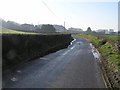
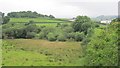
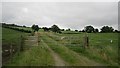
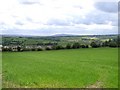
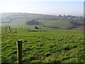
Nearby Images from Geograph Britain and Ireland:
©2008(licence)
©2012(licence)
©2012(licence)
©2006(licence)
©2008(licence)
The above images may not be of the site on this page, they are loaded from Geograph.
Please Submit an Image of this site or go out and take one for us!
Click here to see more info for this site
Nearby sites
Click here to view sites on an interactive map of the areaKey: Red: member's photo, Blue: 3rd party photo, Yellow: other image, Green: no photo - please go there and take one, Grey: site destroyed
Download sites to:
KML (Google Earth)
GPX (GPS waypoints)
CSV (Garmin/Navman)
CSV (Excel)
To unlock full downloads you need to sign up as a Contributory Member. Otherwise downloads are limited to 50 sites.
Turn off the page maps and other distractions
Nearby sites listing. In the following links * = Image available
2.6km W 274° Kilmonaster Site A* Passage Grave
2.8km W 273° Kilmonaster Site D* Passage Grave
5.3km WNW 303° Beltany* Stone Circle (C2543600364)
10.0km SSW 207° Creevy Upper Stone Row / Alignment (H255885)
11.1km E 83° Knocknahorna Stone Circle (H410989)
11.1km E 83° Knocknahorna Multiple Stone Rows / Avenue (H410989)
11.5km NE 50° Sandville and Lisvdin* Standing Stones
12.7km S 173° Crew Lower* Standing Stones (H315848)
13.2km NE 56° Ballynabwee fort* Stone Fort or Dun (C40880495)
13.6km NNW 334° Labbadish Stone Row / Alignment (C238096)
14.4km SW 223° Garvagh Court Tomb Court Tomb (H201869)
14.7km SE 131° Glenknock Portal Tomb Portal Tomb (H411879)
14.7km NNE 23° Cloghfin Standing Stones (C355111)
15.2km SE 130° Crosh Portal Tomb Portal Tomb (H417878)
15.8km E 90° Meendamph B* Stone Circle (H458976)
15.9km E 80° Lisnaragh Irish rath* Stone Fort or Dun (C45690023)
16.0km E 92° Meendamph A Stone Circle (H460970)
16.1km SSE 153° Ballyrenan* Portal Tomb (H3733083180)
16.5km E 98° Balix standing stone* Standing Stone (Menhir) (H46369523)
16.6km E 90° Banagher* Stone Circle (H466977)
16.8km WNW 281° Magherayall* Chambered Tomb (C134007)
18.6km SSW 203° Leitrim Portal Tomb* Portal Tomb (H227803)
18.7km E 80° Loughash Wedge Tomb* Wedge Tomb (C484008)
19.0km E 99° Balix Lower* Court Tomb (H488946)
19.0km E 99° Clogherny Meenerrigal* Stone Circle (H488945)
View more nearby sites and additional images


 We would like to know more about this location. Please feel free to add a brief description and any relevant information in your own language.
 Wir möchten mehr über diese Stätte erfahren. Bitte zögern Sie nicht, eine kurze Beschreibung und relevante Informationen in Deutsch hinzuzufügen.
 Nous aimerions en savoir encore un peu sur les lieux. S'il vous plaît n'hesitez pas à ajouter une courte description et tous les renseignements pertinents dans votre propre langue.
 Quisieramos informarnos un poco más de las lugares. No dude en añadir una breve descripción y otros datos relevantes en su propio idioma.