

<< Text Pages >> Whinny Hill - Round Cairn in Scotland in Northumberland
Submitted by Tom_Bullock on Wednesday, 02 July 2003 Page Views: 4622
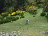
Neolithic and Bronze AgeSite Name: Whinny HillCountry: Scotland County: Northumberland Type: Round Cairn
Map Ref: NO093276 Landranger Map Number: 52
Latitude: 56.431846N Longitude: 3.472336W
Condition:
| 5 | Perfect |
| 4 | Almost Perfect |
| 3 | Reasonable but with some damage |
| 2 | Ruined but still recognisable as an ancient site |
| 1 | Pretty much destroyed, possibly visible as crop marks |
| 0 | No data. |
| -1 | Completely destroyed |
| 5 | Superb |
| 4 | Good |
| 3 | Ordinary |
| 2 | Not Good |
| 1 | Awful |
| 0 | No data. |
| 5 | Can be driven to, probably with disabled access |
| 4 | Short walk on a footpath |
| 3 | Requiring a bit more of a walk |
| 2 | A long walk |
| 1 | In the middle of nowhere, a nightmare to find |
| 0 | No data. |
| 5 | co-ordinates taken by GPS or official recorded co-ordinates |
| 4 | co-ordinates scaled from a detailed map |
| 3 | co-ordinates scaled from a bad map |
| 2 | co-ordinates of the nearest village |
| 1 | co-ordinates of the nearest town |
| 0 | no data |
Internal Links:
External Links:
Round Cairn in Northumberland
This site is actually at grid ref: NU 094 277
Have you visited this site? Please add a comment below.
You may be viewing yesterday's version of this page. To see the most up to date information please register for a free account.
")
")
")
")
")
")
")
")
")
")
")
")
")
")
")
")
")
")
")
")
Do not use the above information on other web sites or publications without permission of the contributor.
Nearby sites
Download sites to:
KML (Google Earth)
GPX (GPS waypoints)
CSV (Garmin/Navman)
CSV (Excel)
To unlock full downloads you need to sign up as a Contributory Member. Otherwise downloads are limited to 50 sites.
Nearby sites listing. In the following links * = Image available
338m NW 325° Broxy Kennels* Hillfort (NO09112788)
793m NNE 30° King's Stone* Standing Stone (Menhir) (NO09712828)
845m N 6° Denmarkfield Farm Standing Stone (Menhir) (NO09402844)
2.3km E 79° Scone Cursus Cursus (NO11532797)
2.3km SSW 194° Hunting Tower Cursus (NO087254)
2.4km ENE 79° Scone Cursus Cursus (NO11712803)
2.8km N 350° Cramflat* Standing Stone (Menhir) (NO0885530322)
2.9km SSW 208° Mains Of Huntingtower Stone Circle (NO079251)
3.6km WNW 288° Moneydie* Stone Circle (NO059288)
3.6km SW 220° Huntingtower Cairn (NO069249)
3.9km NNW 342° Gellybank* Standing Stones (NO082313)
3.9km NNE 25° Colen* Stone Circle (NO110311)
4.1km ESE 105° Sandy Road* Stone Circle (NO1327526463)
4.1km ESE 105° Sandy Road East Stone Circle (NO13282646)
4.6km SE 144° Inchyra* Class I Pictish Symbol Stone (NO119238)
4.6km SE 144° Perth Museum and Art Gallery* Museum (NO119238)
4.6km N 1° Overbenchil* Standing Stone (Menhir) (NO095322)
4.8km SE 134° Murray Royal Hospital* Standing Stone (Menhir) (NO127242)
4.8km N 349° Newmill souterrain* Souterrain (Fogou, Earth House) (NO08513239)
4.9km NE 39° Druids Seat* Stone Circle (NO12483132)
5.6km SSE 150° South Inch, Perth Standing Stone (Menhir) (NO12002274)
5.6km W 280° Lynedoch Cottage (3) Standing Stone (Menhir) (NO03792870)
5.6km NNW 343° Loak Court Hill Round Barrow(s) (NO07733301)
5.6km NE 52° Williamston Stone Circle (NO138310)
5.7km NNW 341° Loak Stone Standing Stone (Menhir) (NO07573305)


 We would like to know more about this location. Please feel free to add a brief description and any relevant information in your own language.
 Wir möchten mehr über diese Stätte erfahren. Bitte zögern Sie nicht, eine kurze Beschreibung und relevante Informationen in Deutsch hinzuzufügen.
 Nous aimerions en savoir encore un peu sur les lieux. S'il vous plaît n'hesitez pas à ajouter une courte description et tous les renseignements pertinents dans votre propre langue.
 Quisieramos informarnos un poco más de las lugares. No dude en añadir una breve descripción y otros datos relevantes en su propio idioma.