

<< Our Photo Pages >> Penrhos (Holyhead) - Standing Stone (Menhir) in Wales in Anglesey
Submitted by guile on Monday, 09 December 2013 Page Views: 6609
Neolithic and Bronze AgeSite Name: Penrhos (Holyhead)Country: Wales County: Anglesey Type: Standing Stone (Menhir)
Nearest Town: Holyhead
Map Ref: SH26828183
Latitude: 53.305024N Longitude: 4.600517W
Condition:
| 5 | Perfect |
| 4 | Almost Perfect |
| 3 | Reasonable but with some damage |
| 2 | Ruined but still recognisable as an ancient site |
| 1 | Pretty much destroyed, possibly visible as crop marks |
| 0 | No data. |
| -1 | Completely destroyed |
| 5 | Superb |
| 4 | Good |
| 3 | Ordinary |
| 2 | Not Good |
| 1 | Awful |
| 0 | No data. |
| 5 | Can be driven to, probably with disabled access |
| 4 | Short walk on a footpath |
| 3 | Requiring a bit more of a walk |
| 2 | A long walk |
| 1 | In the middle of nowhere, a nightmare to find |
| 0 | No data. |
| 5 | co-ordinates taken by GPS or official recorded co-ordinates |
| 4 | co-ordinates scaled from a detailed map |
| 3 | co-ordinates scaled from a bad map |
| 2 | co-ordinates of the nearest village |
| 1 | co-ordinates of the nearest town |
| 0 | no data |
Internal Links:
External Links:
I have visited· I would like to visit
cactus_chris visited on 22nd Feb 2019 - their rating: Cond: 5 Amb: 5 Access: 3 Only accesible via the Anglesey Coastal Path.
 (PID:115629)")
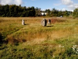
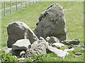
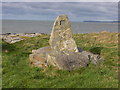
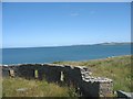
Looking west only the chimney of the aluminium plant can be seen. It is about 1500mm high, with some field clearance stones at its base. This standing stone is marked on W.O. Stanleys’ “Map of the Antiquities of Holy Island 1868”, and also marked on the 1924 OS Map.
At some angles it looks like a half buried MAOI. There are plans afoot by Land & Lakes to “develop” this area, with a restaurant within a few hundred yards of this stone. With no legal protection its future is murky.
You may be viewing yesterday's version of this page. To see the most up to date information please register for a free account.
 (PID:115628)")
 (PID:131195)")
 (PID:132886)")
 (PID:250670)")
Do not use the above information on other web sites or publications without permission of the contributor.
Nearby Images from Geograph Britain and Ireland:
©2015(licence)
©2012(licence)
©2008(licence)
©2008(licence)
©2012(licence)
The above images may not be of the site on this page, they are loaded from Geograph.
Please Submit an Image of this site or go out and take one for us!
Click here to see more info for this site
Nearby sites
Key: Red: member's photo, Blue: 3rd party photo, Yellow: other image, Green: no photo - please go there and take one, Grey: site destroyed
Download sites to:
KML (Google Earth)
GPX (GPS waypoints)
CSV (Garmin/Navman)
CSV (Excel)
To unlock full downloads you need to sign up as a Contributory Member. Otherwise downloads are limited to 50 sites.
Turn off the page maps and other distractions
Nearby sites listing. In the following links * = Image available
1.6km SW 215° Trefignath* Chambered Tomb (SH25858056)
1.7km SW 236° Ty Mawr (Nr Holyhead)* Standing Stone (Menhir) (SH2539480951)
1.7km SSW 192° Trearddur Dolmen* Burial Chamber or Dolmen (SH264802)
2.2km WNW 288° Caer Gybi Roman Fort* Stone Fort or Dun (SH2471882615)
3.0km S 180° Trearddur standing stone* Standing Stone (Menhir) (SH267788)
3.0km SSE 162° Ynys Leurad* Ancient Village or Settlement (SH2764978895)
3.1km WSW 250° Carreg y Bwgan* Natural Stone / Erratic / Other Natural Feature (SH2390380891)
3.8km WSW 241° Porth Dafarch ancient huts* Ancient Village or Settlement (SH234801)
3.9km WNW 298° Stones near Holyhead breakwater* Natural Stone / Erratic / Other Natural Feature (SH2340583806)
4.1km W 265° Gorsedd Gwlwm* Chambered Cairn (SH2275681655)
4.2km WSW 256° Penrhos-Feilw* Standing Stones (SH22708094)
4.5km W 273° Ffynnon y Wrach* Holy Well or Sacred Spring (SH22328226)
4.6km WSW 241° Porthyrhwydau* Cave or Rock Shelter (SH227797)
4.9km SSE 168° Bodior Standing Stone* Standing Stone (Menhir) (SH277770)
5.0km E 95° Shop Farm* Standing Stone (Menhir) (SH3180581223)
5.1km WSW 257° South Stack Stone Pile* Natural Stone / Erratic / Other Natural Feature (SH2177880876)
5.1km W 281° Caer y Twr* Hillfort (SH218830)
5.1km WSW 240° Fort Dinas, Porth Ruffydd* Promontory Fort / Cliff Castle (SH22277941)
5.2km W 271° Maen Bras* Natural Stone / Erratic / Other Natural Feature (SH21608210)
5.2km S 183° Cromlech in Rhoscolyn* Burial Chamber or Dolmen (SH2634376610)
5.5km W 278° Garn Cairn (Holyhead)* Ring Cairn (SH21408276)
5.7km W 269° Holyhead Mountain* Ancient Village or Settlement (SH21128196)
5.7km S 187° Bwa Gwyn* Natural Stone / Erratic / Other Natural Feature (SH259762)
6.4km S 186° St Gwenfaens Well* Holy Well or Sacred Spring (SH2594975436)
6.5km SE 143° Llyn Cerrig Bach* Natural Stone / Erratic / Other Natural Feature (SH30607650)
View more nearby sites and additional images


 We would like to know more about this location. Please feel free to add a brief description and any relevant information in your own language.
 Wir möchten mehr über diese Stätte erfahren. Bitte zögern Sie nicht, eine kurze Beschreibung und relevante Informationen in Deutsch hinzuzufügen.
 Nous aimerions en savoir encore un peu sur les lieux. S'il vous plaît n'hesitez pas à ajouter une courte description et tous les renseignements pertinents dans votre propre langue.
 Quisieramos informarnos un poco más de las lugares. No dude en añadir una breve descripción y otros datos relevantes en su propio idioma.