

<< Our Photo Pages >> Bach Hill Barrows - Round Barrow(s) in Wales in Powys
Submitted by jfarrar on Saturday, 10 August 2013 Page Views: 2285
Neolithic and Bronze AgeSite Name: Bach Hill BarrowsCountry: Wales County: Powys Type: Round Barrow(s)
Nearest Town: New Radnor
Map Ref: SO21396365
Latitude: 52.265370N Longitude: 3.153304W
Condition:
| 5 | Perfect |
| 4 | Almost Perfect |
| 3 | Reasonable but with some damage |
| 2 | Ruined but still recognisable as an ancient site |
| 1 | Pretty much destroyed, possibly visible as crop marks |
| 0 | No data. |
| -1 | Completely destroyed |
| 5 | Superb |
| 4 | Good |
| 3 | Ordinary |
| 2 | Not Good |
| 1 | Awful |
| 0 | No data. |
| 5 | Can be driven to, probably with disabled access |
| 4 | Short walk on a footpath |
| 3 | Requiring a bit more of a walk |
| 2 | A long walk |
| 1 | In the middle of nowhere, a nightmare to find |
| 0 | No data. |
| 5 | co-ordinates taken by GPS or official recorded co-ordinates |
| 4 | co-ordinates scaled from a detailed map |
| 3 | co-ordinates scaled from a bad map |
| 2 | co-ordinates of the nearest village |
| 1 | co-ordinates of the nearest town |
| 0 | no data |
Internal Links:
External Links:
")
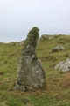
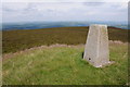
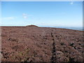
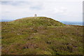
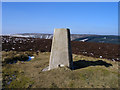
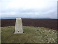
Three round barrows on Bach Hill.
The first has a triangulation point on top of it Coflein Entry
The first is a good, heather covered barrow. Coflein Entry
The third is on private land and much ploughed down. Coflein Entry
You may be viewing yesterday's version of this page. To see the most up to date information please register for a free account.
")
Do not use the above information on other web sites or publications without permission of the contributor.
Nearby Images from Geograph Britain and Ireland:
©2012(licence)
©2012(licence)
©2012(licence)
©2014(licence)
©2012(licence)
The above images may not be of the site on this page, they are loaded from Geograph.
Please Submit an Image of this site or go out and take one for us!
Click here to see more info for this site
Nearby sites
Key: Red: member's photo, Blue: 3rd party photo, Yellow: other image, Green: no photo - please go there and take one, Grey: site destroyed
Download sites to:
KML (Google Earth)
GPX (GPS waypoints)
CSV (Garmin/Navman)
CSV (Excel)
To unlock full downloads you need to sign up as a Contributory Member. Otherwise downloads are limited to 50 sites.
Turn off the page maps and other distractions
Nearby sites listing. In the following links * = Image available
881m SW 230° Whinyard Rocks Barrows* Round Barrow(s) (SO207631)
1.4km SW 219° Whimble Barrow* Round Barrow(s) (SO205626)
1.9km WNW 289° Black Mixen Barrows* Round Barrow(s) (SO196643)
3.2km ESE 112° Crossfield Lane Barrow (Kinnerton)* Round Barrow(s) (SO24356243)
3.3km ESE 105° Kinnerton* Standing Stones (SO24566274)
4.1km WNW 287° Cwm Bwch Barrows* Round Barrow(s) (SO175649)
4.2km SE 130° Four Stones Barrow Cemetary* Barrow Cemetery (SO24596091)
4.3km SE 131° Four Stones (Powys)* Stone Circle (SO24576080)
4.4km ESE 122° Upper Ninepence barrow and Neolithic enclosure Round Barrow(s) (SO251613)
4.4km SE 134° Hindwell Cursus* Cursus (SO24496052)
4.4km SE 127° The Hindwell Stone* Standing Stone (Menhir) (SO24916093)
4.6km SE 129° Hindwell Cursus* Cursus (SO24926074)
4.6km SE 142° Harpton Round Barrows* Round Barrow(s) (SO24225998)
4.7km SE 125° Hindwell Farm 2* Round Barrow(s) (SO25226091)
4.7km E 83° Beggar's Bush Barrow* Round Barrow(s) (SO26096417)
4.9km SE 138° Knapp Mount Barrow* Barrow Cemetery (SO2458659975)
5.0km SE 126° Hindwell Farm 1* Round Barrow(s) (SO25376064)
5.0km ESE 120° Hindwell Ash* Round Barrow(s) (SO25706111)
5.0km SE 125° Hindwell Enclosure* Timber Circle (SO2544560720)
5.2km E 90° Castle Ring (Powys)* Hillfort (SO26646360)
5.3km SE 133° Walton Palisaded Enclosure* Timber Circle (SO25235996)
5.4km ESE 115° Knobley Stone* Standing Stone (Menhir) (SO26296132)
5.6km ESE 119° Hindwell Causewayed Enclosure* Causewayed Enclosure (SO26246092)
5.8km SE 141° Old Radnor Church* Standing Stone (Menhir) (SO24995909)
6.1km WNW 286° Shepherd's Tump* Round Barrow(s) (SO155654)
View more nearby sites and additional images


 We would like to know more about this location. Please feel free to add a brief description and any relevant information in your own language.
 Wir möchten mehr über diese Stätte erfahren. Bitte zögern Sie nicht, eine kurze Beschreibung und relevante Informationen in Deutsch hinzuzufügen.
 Nous aimerions en savoir encore un peu sur les lieux. S'il vous plaît n'hesitez pas à ajouter une courte description et tous les renseignements pertinents dans votre propre langue.
 Quisieramos informarnos un poco más de las lugares. No dude en añadir una breve descripción y otros datos relevantes en su propio idioma.