 with our Megalithic Portal iPhone app")


<< Image Pages >> Udayagiri and Khandagiri Cave Temples - Ancient Temple in India
Submitted by durhamnature on Sunday, 31 March 2013 Page Views: 7843
Multi-periodSite Name: Udayagiri and Khandagiri Cave TemplesCountry: India Type: Ancient Temple
Nearest Town: Bhubaneswar
Latitude: 20.262831N Longitude: 85.786030E
Condition:
| 5 | Perfect |
| 4 | Almost Perfect |
| 3 | Reasonable but with some damage |
| 2 | Ruined but still recognisable as an ancient site |
| 1 | Pretty much destroyed, possibly visible as crop marks |
| 0 | No data. |
| -1 | Completely destroyed |
| 5 | Superb |
| 4 | Good |
| 3 | Ordinary |
| 2 | Not Good |
| 1 | Awful |
| 0 | No data. |
| 5 | Can be driven to, probably with disabled access |
| 4 | Short walk on a footpath |
| 3 | Requiring a bit more of a walk |
| 2 | A long walk |
| 1 | In the middle of nowhere, a nightmare to find |
| 0 | No data. |
| 5 | co-ordinates taken by GPS or official recorded co-ordinates |
| 4 | co-ordinates scaled from a detailed map |
| 3 | co-ordinates scaled from a bad map |
| 2 | co-ordinates of the nearest village |
| 1 | co-ordinates of the nearest town |
| 0 | no data |
Internal Links:
External Links:
")
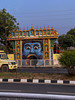
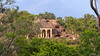
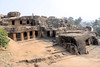
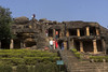
Two nearby sets of cave temples in Odisha. There are 18 Udayagiri caves and 15 at Khandagiri, the temples being constructed mainly between 193 BCE and 170 BCE. Some of the original temple caves may have been destroyed.
You may be viewing yesterday's version of this page. To see the most up to date information please register for a free account.
")
")
Do not use the above information on other web sites or publications without permission of the contributor.
Nearby Images from Flickr

The above images may not be of the site on this page, but were taken nearby. They are loaded from Flickr so please click on them for image credits.
Click here to see more info for this site
Nearby sites
Click here to view sites on an interactive map of the areaKey: Red: member's photo, Blue: 3rd party photo, Yellow: other image, Green: no photo - please go there and take one, Grey: site destroyed
Download sites to:
KML (Google Earth)
GPX (GPS waypoints)
CSV (Garmin/Navman)
CSV (Excel)
To unlock full downloads you need to sign up as a Contributory Member. Otherwise downloads are limited to 50 sites.
Turn off the page maps and other distractions
Nearby sites listing. In the following links * = Image available
46m SW 216° Udaigiri Caves* Cave or Rock Shelter
2.3km ENE 68° Vaital temple* Ancient Temple
5.4km ESE 118° Lingraj temple* Ancient Temple
5.6km ESE 114° Bindu Sagar* Ancient Temple
5.9km ESE 121° Brahmeshwara temple* Ancient Temple
6.1km ESE 112° Mukteshwar Temple* Ancient Temple
6.1km ESE 112° Kedar Gouri Temple* Ancient Temple
6.1km ESE 110° Parsusrameswar temple* Ancient Temple
6.4km ESE 110° Rajarani temple* Ancient Temple
52.7km SE 142° Konarak sun temple* Ancient Temple
256.6km N 1° Chaibasa Standing Stones
269.6km NW 312° Ulapgarh Ushakuthi Rock Art
271.2km NW 310° Vikramkhol Rock Art
323.6km N 3° Chokahatu* Barrow Cemetery
405.2km N 352° Punkri Burwadih* Chambered Tomb
416.4km N 355° Rola.* Standing Stones
425.6km N 1° Dhekia Pathar* Burial Chamber or Dolmen
443.5km WNW 282° Tarighat* Ancient Village or Settlement
532.6km N 352° Barabar Caves* Cave or Rock Shelter
543.1km N 356° Nalanda University excavated site* Ancient Temple
549.6km NNW 329° Obra standing stones Standing Stones
555.3km N 354° Telhara Ancient Temple
637.3km NE 34° Mahasthangarh Ancient Village or Settlement
650.9km NE 50° Wari-Bateswar Ancient Village or Settlement
690.5km SW 234° Undavalli cave temple* Ancient Temple
View more nearby sites and additional images


 We would like to know more about this location. Please feel free to add a brief description and any relevant information in your own language.
 Wir möchten mehr über diese Stätte erfahren. Bitte zögern Sie nicht, eine kurze Beschreibung und relevante Informationen in Deutsch hinzuzufügen.
 Nous aimerions en savoir encore un peu sur les lieux. S'il vous plaît n'hesitez pas à ajouter une courte description et tous les renseignements pertinents dans votre propre langue.
 Quisieramos informarnos un poco más de las lugares. No dude en añadir una breve descripción y otros datos relevantes en su propio idioma.