 with our Megalithic Portal iPhone app")

<< Other Photo Pages >> Vedbæk mesolithic cemetery - Ancient Village or Settlement in Denmark in Hovedstaden
Submitted by Andy B on Thursday, 01 November 2012 Page Views: 35418
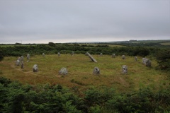
Multi-periodSite Name: Vedbæk mesolithic cemetery Alternative Name: Vedbaek burial, Bøgebakken archaeological siteCountry: Denmark County: Hovedstaden Type: Ancient Village or Settlement
Nearest Village: Vedbæk
Latitude: 55.852000N Longitude: 12.560540E
Condition:
| 5 | Perfect |
| 4 | Almost Perfect |
| 3 | Reasonable but with some damage |
| 2 | Ruined but still recognisable as an ancient site |
| 1 | Pretty much destroyed, possibly visible as crop marks |
| 0 | No data. |
| -1 | Completely destroyed |
| 5 | Superb |
| 4 | Good |
| 3 | Ordinary |
| 2 | Not Good |
| 1 | Awful |
| 0 | No data. |
| 5 | Can be driven to, probably with disabled access |
| 4 | Short walk on a footpath |
| 3 | Requiring a bit more of a walk |
| 2 | A long walk |
| 1 | In the middle of nowhere, a nightmare to find |
| 0 | No data. |
| 5 | co-ordinates taken by GPS or official recorded co-ordinates |
| 4 | co-ordinates scaled from a detailed map |
| 3 | co-ordinates scaled from a bad map |
| 2 | co-ordinates of the nearest village |
| 1 | co-ordinates of the nearest town |
| 0 | no data |
Internal Links:
External Links:
I have visited· I would like to visit
Andy B has visited here
")
The triple burial yielded two adults and a one-year-old child. While all individuals except one were buried in a supine position, other aspects of the
burials were varied and related to age and sex.
The five children’s burials all contain ochre, while of the seven women’s burials two have no grave goods at all and three others only ochre. One woman was buried with a flint blade and various roe-deer bones, another woman was buried in a
dress decorated with pendants of red-deer and pig teeth alongside small perforated shells.
It appears that the age of the women determined the grave goods: the mature women received no grave goods apart from ochre, while the sole adult woman in the cemetery received a blade and bones of a roe deer.
. Seven of the nine male adult burials contained one or more flint blades, often in association with other
goods: ochre, an antler axe, a bone tool, pig-tooth pendants.
The child's gravegoods suggest that the culture involved ascribed status – the passing of power between generations.
The cemetery is located in the northern part of the Maglemosen peat bog, and was discovered in 1975 during excavation for the new Vedbæk School. (It should not be confused with the earlier Maglemosian culture, named for a different Maglemose near Slagelse.)
Source:
The process of Neolithisation, Leiden University (PDF)
See also
http://www.sjsu.edu/people/marco.meniketti/courses/LostCiv2/s0/Vedbeack.pdf
You may be viewing yesterday's version of this page. To see the most up to date information please register for a free account.
Do not use the above information on other web sites or publications without permission of the contributor.
Nearby Images from Flickr


The above images may not be of the site on this page, but were taken nearby. They are loaded from Flickr so please click on them for image credits.
Click here to see more info for this site
Nearby sites
Click here to view sites on an interactive map of the areaKey: Red: member's photo, Blue: 3rd party photo, Yellow: other image, Green: no photo - please go there and take one, Grey: site destroyed
Download sites to:
KML (Google Earth)
GPX (GPS waypoints)
CSV (Garmin/Navman)
CSV (Excel)
To unlock full downloads you need to sign up as a Contributory Member. Otherwise downloads are limited to 50 sites.
Turn off the page maps and other distractions
Nearby sites listing. In the following links * = Image available
1.4km SSE 167° Vedbæk Kirke Stenkiste* Cist
1.7km SSE 152° Lokeshøi* Round Barrow(s)
1.9km WNW 294° Folehaven Rundhøj 12* Round Barrow(s)
1.9km WNW 294° Folehaven Rundhøj 11* Round Barrow(s)
2.1km NW 313° Folehaven Langdysse 2* Long Barrow
2.3km WNW 299° Folehaven Langdysse 4* Long Barrow
2.3km NW 321° Folehaven Rundhøj 7* Round Barrow(s)
2.4km NW 321° Folehaven Rundhøj 6* Round Barrow(s)
2.4km NW 322° Folehaven Rundhøj 5* Round Barrow(s)
2.4km WNW 298° Sandbjerg Østerskov Hellekiste* Cist
2.5km NW 305° Folehaven Rundhøj 8* Round Barrow(s)
2.5km SW 224° Kohave Skov Hellekiste* Cist
2.7km WNW 300° Folehaven Rundhøj 9* Round Barrow(s)
2.7km WNW 299° Folehaven Rundhøj 10* Round Barrow(s)
2.7km NW 315° Folehaven Rundhøj 4* Round Barrow(s)
2.8km W 270° Sandbjerg Langdysse* Long Barrow
2.8km NW 318° Folehaven Rundhøj 3* Round Barrow(s)
3.1km WNW 298° Folehaven Langdysse 3* Long Barrow
3.2km WNW 299° Folehaven Langdysse 1* Long Barrow
3.5km SSE 167° Skodsborg Hellekister* Cist
3.8km NW 319° Folehaven Rundhøj 2* Round Barrow(s)
3.8km NW 320° Folehaven Rundhøj 1* Round Barrow(s)
3.8km NW 320° Folehaven Stensætning* Ring Cairn
4.9km NW 322° Vallerød Runddysse* Burial Chamber or Dolmen
5.3km SSE 166° Møllevang* Round Barrow(s)
View more nearby sites and additional images


 We would like to know more about this location. Please feel free to add a brief description and any relevant information in your own language.
 Wir möchten mehr über diese Stätte erfahren. Bitte zögern Sie nicht, eine kurze Beschreibung und relevante Informationen in Deutsch hinzuzufügen.
 Nous aimerions en savoir encore un peu sur les lieux. S'il vous plaît n'hesitez pas à ajouter une courte description et tous les renseignements pertinents dans votre propre langue.
 Quisieramos informarnos un poco más de las lugares. No dude en añadir una breve descripción y otros datos relevantes en su propio idioma.