Featured: How and why the ancients enchanted Great Britain and Brittany

How and why the ancients enchanted Great Britain and Brittany

A Little History of Astro-Archaeology £4.99+p&p

A Little History of Astro-Archaeology £4.99+p&p

Who's Online

There are currently, 372 guests and 1 members online.

You are a guest. To join in, please register for free by clicking here

Sponsors

<< Our Photo Pages >> Seminole Canyon State Park and Historic Site - Rock Art in United States in The Southwest

Submitted by davidmorgan on Monday, 21 September 2015  Page Views: 8872

Rock ArtSite Name: Seminole Canyon State Park and Historic Site Alternative Name: Panther Cave, Fate Bell Shelter, Black Cave
Country: United States Region: The Southwest Type: Rock Art
Nearest Town: Del Rio  Nearest Village: Comstock
Latitude: 29.662013N  Longitude: 101.313054W
Condition:
5Perfect
4Almost Perfect
3Reasonable but with some damage
2Ruined but still recognisable as an ancient site
1Pretty much destroyed, possibly visible as crop marks
0No data.
-1Completely destroyed
4 Ambience:
5Superb
4Good
3Ordinary
2Not Good
1Awful
0No data.
4 Access:
5Can be driven to, probably with disabled access
4Short walk on a footpath
3Requiring a bit more of a walk
2A long walk
1In the middle of nowhere, a nightmare to find
0No data.
2 Accuracy:
5co-ordinates taken by GPS or official recorded co-ordinates
4co-ordinates scaled from a detailed map
3co-ordinates scaled from a bad map
2co-ordinates of the nearest village
1co-ordinates of the nearest town
0no data
4

Internal Links:
External Links:

Seminole Canyon State Park and Historic Site
Seminole Canyon State Park and Historic Site submitted by Creative Commons : "Screaming Panther", a Pecos River-style pictograph in the Fate Bell Annex (41VV73.) "Stylistic variations on the panther theme abound. Depending upon the skill of the artist, they appear with mighty bristling tails (one outstanding characteristic of the native cougar is the length of their tails), roaring defiance from an attack posture, or like loveable cartoon figures, more pig than panthe... (Vote or comment on this photo)
Rock Art in Texas. This page includes several sites of the Pecos River culture in the Seminole Canyon State Historical Park.

Seminole Canyon State Park and Historic Site in Val Verde County, west of Comstock, contains 2172.5 acres; the park was acquired by purchase from private owners in 1973 - 1977 and opened in February 1980.

Early man first visited this area 12,000 years ago, a time when now-extinct species of elephant, camel, bison, and horse roamed the landscape. The climate at that time was more moderate than today and supported a more lush vegetation that included pine, juniper, and oak woodlands in the canyons, with luxuriant grasslands on the uplands. These early people developed a hunting culture based upon large mammals, such as the mammoth and bison. No known evidence exists that these first inhabitants produced any rock paintings.

By 7000 years ago, the region had undergone a climatic change that produced a landscape much like today's. A new culture appeared in this changed environment. These people were increasingly dependent on gathering wild plants and hunting small animals and less dependent on hunting big game. They lived in small groups since the land would not support larger social units for long periods.

Despite the struggle for survival, some of these prehistoric people found the creative energy to paint the pictographs found in Fate Bell and other rock shelters of the Lower Pecos River Country. The distribution of this distinct style is limited to a district which includes a portion of the Rio Grande, Pecos, and Devils River. More than 200 pictograph sites are known to contain examples of their style of rock paintings ranging from single paintings to caves containing panels of art hundreds of feet long. Although numerous figures or motifs are repeated in different locations, the exact meaning of the paintings is buried with the people who painted them.

The Fate Bell Shelter Tour is held daily Wednesday through Sunday. Tours are subject to cancellation due to rain or hot temperatures. The Fate Bell Shelter Tour involves a fairly-rugged hike to the bottom of the canyon and then up to the shelter to view many good examples of American Indian rock paintings in Fate Bell Shelter.

Park staff & volunteers with the private, nonprofit Rock Art Foundation conduct tours of the Fate Bell Shelter, continuing the group's history of support for the site. The shelter is a huge cliff overhang containing some of the state's most spectacular American rock paintings.

More on the official web site of the Seminole Canyon State Historical Park.

Note: The 2015 Rock Art Foundation Annual Rendezvous, Oct 16-18th, Comstock, Val Verde, Texas
You may be viewing yesterday's version of this page. To see the most up to date information please register for a free account.


Seminole Canyon State Park and Historic Site
Seminole Canyon State Park and Historic Site submitted by Creative Commons : The entire "Dancing Shaman" pictograph panel from Black Cave (41VV76.) The Dancing Shaman is on the right. The image may depict shamans in a transformation state. (www.texasbeyondhistory.net/hueco/images/ras.html) "The shaman figure is normally static, frozen in a frontal pose with arms upraised. This unusual composition from Black Cave, often called the dancing shaman, is one of the fe... (Vote or comment on this photo)

Seminole Canyon State Park and Historic Site
Seminole Canyon State Park and Historic Site submitted by Creative Commons : Dancing Shaman pictograph in Black Cave (41VV76.) The image may depict shamans in a transformation state. (www.texasbeyondhistory.net/hueco/images/ras.html) "The shaman figure is normally static, frozen in a frontal pose with arms upraised. This unusual composition from Black Cave, often called the dancing shaman, is one of the few where action or interaction can be inferred. It has been... (Vote or comment on this photo)

Seminole Canyon State Park and Historic Site
Seminole Canyon State Park and Historic Site submitted by Creative Commons : "The Triad", a large Pecos River-style pictograph panel in Fate Bell. "Called the Triad, although at least four and perhaps five figures are discernible through the layers of superimposed paint, this panel dominates the rock art at Fate Bell Shelter, the largest shelter in the Lower Pecos area and the focal point of Seminole Canyon State Park & Historic Site. The figure in the center of the p... (Vote or comment on this photo)

Seminole Canyon State Park and Historic Site
Seminole Canyon State Park and Historic Site submitted by Creative Commons : Red linear pictograph in Site 41VV201 (Red Linear Site) along Presa Canyon. Believed to date from around 500-700 B.C., red linear rock art depicts everyday activities, such as fertility rituals. (www.texasbeyondhistory.net/hueco/images/ras.html) "The first and only Red Linear site known to Kirkland, Jackson, and Newcomb consists of two major panels. One shows what appears to be combat between... (Vote or comment on this photo)

Seminole Canyon State Park and Historic Site
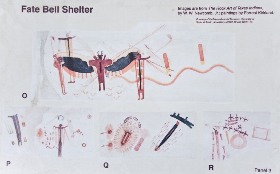
Seminole Canyon State Park and Historic Site submitted by Creative Commons : Interpretive sign showing Forrest Kirkland's watercolor renditions of panels in the Fate Bell shelter (41VV74) Creative commons photo by 12fh (Vote or comment on this photo)

Seminole Canyon State Park and Historic Site
Seminole Canyon State Park and Historic Site submitted by Creative Commons : Part of "Sky-Earth", a large pictograph panel in the Fate Bell shelter (41VV73.) Creative commons photo by 12fh

Do not use the above information on other web sites or publications without permission of the contributor.
Click here to see more info for this site

Nearby sites

Click here to view sites on an interactive map of the area

Key: Red: member's photo, Blue: 3rd party photo, Yellow: other image, Green: no photo - please go there and take one, Grey: site destroyed

Download sites to:
KML (Google Earth)
GPX (GPS waypoints)
CSV (Garmin/Navman)
CSV (Excel)

To unlock full downloads you need to sign up as a Contributory Member. Otherwise downloads are limited to 50 sites.


Turn off the page maps and other distractions

Nearby sites listing. In the following links * = Image available
 17.5km N 9° Little Sotol Ancient Village or Settlement
 28.2km NNW 334° Hinds Cave Cave or Rock Shelter
 30.3km ENE 72° Delicado Shelter Rock Art
 194.0km ENE 76° Stonehenge II (Original Location)* Modern Stone Circle etc
 197.1km W 272° Bee Cave Canyon* Cave or Rock Shelter
 204.2km ENE 77° Stonehenge II (Ingram, TX)* Modern Stone Circle etc
 257.6km ENE 68° Enchanted Rock* Natural Stone / Erratic / Other Natural Feature
 266.2km NNW 339° UTPB Stonehenge Replica* Modern Stone Circle etc
 298.9km ENE 68° Nightengale Archaeological Center* Ancient Village or Settlement
 306.6km SSW 194° Cuatro Cienegas Footprints Ancient Trackway
 327.3km E 85° Spring Lake Ancient Village or Settlement
 377.1km ENE 68° Gault Site Ancient Village or Settlement
 378.4km ENE 68° Debra L. Friedkin Ancient Mine, Quarry or other Industry
 407.6km S 171° Boca de Potrerillos Rock Art
 516.4km WNW 300° Hueco Tanks State Park & Historic Site* Rock Art
 528.6km NE 48° Caelum Moor* Modern Stone Circle etc
 547.0km NNW 340° Blackwater Draw* Museum
 549.1km NE 46° The Flower Mound Natural Stone / Erratic / Other Natural Feature
 551.3km WNW 295° Caballo Blanco de Juárez Hill Figure or Geoglyph
 572.2km E 88° Houston Museum of Natural Science* Museum
 590.6km NW 308° Fossilized Footprints - White Sands National Park* Ancient Trackway
 604.8km NW 314° Three Rivers Petroglyphs* Rock Art
 612.7km WNW 303° Summerford Mountain Archaeology District Rock Art
 627.7km ENE 68° Caddo Mounds* Ancient Village or Settlement
 643.5km W 279° Paquime Ancient Village or Settlement
View more nearby sites and additional images

<< Mantviliškų akmuo

Bocan Court Tomb >>

Please add your thoughts on this site

Places of Power, Paul Devereux

Places of Power, Paul Devereux

Sponsors

Auto-Translation (Google)

Translate from English into:

"Seminole Canyon State Park and Historic Site" | Login/Create an Account | 5 News and Comments
  
Go back to top of page    Comments are owned by the poster. We aren't responsible for their content.
The 2015 Rock Art Foundation Annual Rendezvous, Oct 16-18th, Comstock, Val Verde by Andy B on Monday, 21 September 2015
(User Info | Send a Message)
COMSTOCK, Val Verde Co.Oct. 16-18
• Rock Art Foundation Annual Rendezvous
The 2015 Rendezvous will be held at the White Shaman Preserve and will offer as many rock art tours as possible over the weekend. Tours that are planned: White Shaman, Shumla School Campus, Meyers Springs, Bonfire Shelter, Eagle Cave, and Curly Tail Panther. Camping will be available at the White Shaman Preserve.

Coffee and sweet rolls will be served Saturday and Sunday mornings with a BBQ dinner on Saturday night. Admission: $70 per person; free for 12 and younger with parents. Friday
through Sunday. Information: Greg Williams, 210.525.9907, rockartfoundation@gmail.com,
http://www.rockart.org/tours_events/events.cfm

More events from Texas Archaeology month here
http://www.thc.state.tx.us/public/upload/preserve/TAM/TAM-2015-Online-Calendar.pdf
and see also
http://www.thc.state.tx.us/preserve/projects-and-programs/texas-archeology-month

Another one at he other side of Texas, near Houston:
ANGLETON, Brazoria Co. Oct. 8 • Presentation:
Clovis Site Kingwood, Texas
Wilson W. "Dub" Crook, will speak on a new archeological site discovered recently in the Kingwood area of Harris County. The site, known as “Timber Fawn”, is located in the new Rivergrove subdivision on the south side of the San Jacinto River. To date, 24 artifacts characteristic of the Clovis culture have been recovered. Dating to nearly 13,000 years Before Present, the Timber Fawn site clearly marks the earliest known occupation of humans in the Kingwood area. Dub will speak on the traits that make up the Clovis culture as well as discuss all the artifacts recovered from the Timber Fawn site. Sponsored by Brazoria County Historical Museum. Free. Thursday, 6:30 p.m. at Brazoria County Historical Museum, 100 East Cedar Street. Information: Michael Bailey,
979.864.1591, curator@bchm.org, http://www.bchm.org
See also
http://txhas.org/PDF/newsletters/2015/2015%20May%20Profile.pdf
http://txhas.org/
[ Reply to This ]

Record and protect: the rock art of the Rio Grande by bat400 on Thursday, 10 May 2012
(User Info | Send a Message)
From a similar article submitted by coldrum: Dr Carolyn Boyd is the Executive Director of the Shumla School, the organisation initiated to study and preserve the ancient rock art of the Lower Pecos River. The Shumla School is now offering courses to study the work in this region.

One of the areas of study at the field-school is looking at how the paint for the artwork was made with deer marrow fat and how the paintings could have lasted for thousands of years – until now.

Doctor Boyd is quoted as saying, “I feel like I’m in a race against time. If someone walked up to you and handed you the oldest known book in the Western Hemisphere, what would you do? Most people would spare no effort to preserve and protect it”.

http://www.pasthorizonspr.com.
[ Reply to This ]

Prehistoric People of the Lower Pecos Region, Seminole Canyon, Tx by Andy B on Wednesday, 09 May 2012
(User Info | Send a Message)
[ Reply to This ]

Fate Bell Rockshelter Pictograph Tour by Andy B on Wednesday, 09 May 2012
(User Info | Send a Message)
Running every Wednesday-Sunday until May 27, 2012. This two-mile, guided, walking tour descends into a limestone canyon where you will view Pecos Style pictographs. The shelter contains 4,000-year-old Pecos River Style Pictographs, among the oldest, most colorful, complex and distinctive ancient paintings in all of the Americas.

http://www.tpwd.state.tx.us/state-parks/seminole-canyon/park_events/
[ Reply to This ]

Panther Cave: Rock Art in Danger by davidmorgan on Monday, 30 April 2012
(User Info | Send a Message)
In the dramatically scenic canyon of the Lower Pecos River, where ancient limestone cliffs rise steeply above from the water’s surface, and prehistoric rock art awaits in hundreds of shelters eroded over eons from the sheer rock face, it seems odd that a single year would be the topic of conversation. After all, the surrounding desert landscape appears almost eternal, and on the waters of Lake Amistad, the craggy shoreline environment suggests that time should be considered in a sweep much more vast than just one number on the calendar of history: 1954.

But 1954 is the year we’re discussing as our group of four floats in a National Park Service jet boat on Lake Amistad. The boat sits mid-channel, at the point where the Pecos joins the Rio Grande, not far from the US 90 high bridge, west of Comstock.

Why this year instead of all others?

That’s the year of the greatest, most devastating flood ever recorded on the Pecos. One summer day, in the midst of a drought, the remnants of a hurricane named Alice deluged the Pecos watershed with more than 20 inches of rain in a 24-hour period, sending a 95-foot wall of water down the canyon and into the Rio Grande. The existing highway bridge across the river was ripped from its moorings not far from where we now sit.

Such weather-borne savagery seems a distant possibility on this warm autumn morning, as the members of our group discuss the environment of the Lower Pecos. In the boat is rock art expert Carolyn Boyd, Executive Director of the nearby Shumla School; archeologist Jack Johnson, a program manager with the National Park Service; and Randy Rosales, Superintendent of Seminole Canyon State Park. The three organizations these people represent: The National Park Service, Shumla School, and the Texas Parks and Wildlife Department, are collaborating on a project to document Panther Cave, site of one of the area’s most well-known—and most threatened—ancient rock art panels.

As part of the Panther Cave project, researchers document every painted figure in painstaking detail. The documentary and preservation project is a collaboration among the SHUMLA School, the National Park Service, and the Texas Parks and Wildlife Department.

As part of the Panther Cave project, researchers document every painted figure in painstaking detail. The documentary and preservation project is a collaboration among the SHUMLA School, the National Park Service, and the Texas Parks and Wildlife Department.
Before we proceed to Panther Cave, we’re taking a few minutes to watch the screen of the boat’s depth finder, noting the numbers that indicate how many feet of the lake’s water lie beneath us here at the canyon’s mouth: 12 feet here, 18 feet there, 21 feet in another place. The reality is that, even though this canyon is more than 80 feet deep, flood waters would not scour out the more than 60 feet of sediment that has settled during the 40-plus years since Lake Amistad was created. Instead of scouring out the sediment, surging flood waters would be expected to rise above the current lake level. That means that Panther Cave, seven miles downstream, would be completely inundated, and probably destroyed. In fact, all the rock art panels in the region are, to at least some degree, subject to the damaging effects of erosion and vandalism, but Panther Cave is more precarious because the lake’s water laps at the shoreline only yards below the shelter. Even the mud daubers seem to be conspiring against this fragile cultural site, building their thumb-sized adobe homes atop centuries-old painted surfaces.

More at http://www.texashighways.com/index.php/component/content/article/38-outdoors/6390-panther-cave-rock-art-in-danger

Submitted by coldrum.
[ Reply to This ]

Your Name: Anonymous [ Register Now ]
Subject:


Add your comment or contribution to this page. Spam or offensive posts are deleted immediately, don't even bother

<<< What is five plus one as a number? (Please type the answer to this question in the little box on the left)
You can also embed videos and other things. For Youtube please copy and paste the 'embed code'.
For Google Street View please include Street View in the text.
Create a web link like this: <a href="https://www.megalithic.co.uk">This is a link</a>  

Allowed HTML is:
<p> <b> <i> <a> <img> <em> <br> <strong> <blockquote> <tt> <li> <ol> <ul> <object> <param> <embed> <iframe>

We would like to know more about this location. Please feel free to add a brief description and any relevant information in your own language.
Wir möchten mehr über diese Stätte erfahren. Bitte zögern Sie nicht, eine kurze Beschreibung und relevante Informationen in Deutsch hinzuzufügen.
Nous aimerions en savoir encore un peu sur les lieux. S'il vous plaît n'hesitez pas à ajouter une courte description et tous les renseignements pertinents dans votre propre langue.
Quisieramos informarnos un poco más de las lugares. No dude en añadir una breve descripción y otros datos relevantes en su propio idioma.