<< Our Photo Pages >> Achacha Cairn - Cairn in Scotland in Argyll
Submitted by ericjohn7 on Saturday, 03 March 2012 Page Views: 3342
Neolithic and Bronze AgeSite Name: Achacha CairnCountry: Scotland County: Argyll Type: Cairn
Nearest Village: Barcaldine
Map Ref: NM94364076
Latitude: 56.513800N Longitude: 5.34393W
Condition:
| 5 | Perfect |
| 4 | Almost Perfect |
| 3 | Reasonable but with some damage |
| 2 | Ruined but still recognisable as an ancient site |
| 1 | Pretty much destroyed, possibly visible as crop marks |
| 0 | No data. |
| -1 | Completely destroyed |
| 5 | Superb |
| 4 | Good |
| 3 | Ordinary |
| 2 | Not Good |
| 1 | Awful |
| 0 | No data. |
| 5 | Can be driven to, probably with disabled access |
| 4 | Short walk on a footpath |
| 3 | Requiring a bit more of a walk |
| 2 | A long walk |
| 1 | In the middle of nowhere, a nightmare to find |
| 0 | No data. |
| 5 | co-ordinates taken by GPS or official recorded co-ordinates |
| 4 | co-ordinates scaled from a detailed map |
| 3 | co-ordinates scaled from a bad map |
| 2 | co-ordinates of the nearest village |
| 1 | co-ordinates of the nearest town |
| 0 | no data |
Internal Links:
External Links:
")
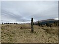
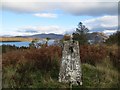
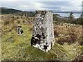
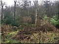
Achacha Cairn is situated between Benderloch and Barcaldine on the hill above the sea life centre, easiest access via Coffin Road from Barcaldine, or from main road via Mill Farm forestry road. It is situated in an area of upland pasture between Cnoc Reamhar and Allt Garraich. Oval in shape measuring 4.6 metres x 4 metres. It is kerbed by a series of granite boulders.
Open views south-west towards Benderloch and Ben Lora and open views east towards Achacha standing stone 80 yards away and Beinn Bhreac.
You may be viewing yesterday's version of this page. To see the most up to date information please register for a free account.
")
Do not use the above information on other web sites or publications without permission of the contributor.
Nearby Images from Geograph Britain and Ireland:
©2022(licence)
©2019(licence)
©2022(licence)
©2015(licence)
©2022(licence)
The above images may not be of the site on this page, they are loaded from Geograph.
Please Submit an Image of this site or go out and take one for us!
Click here to see more info for this site
Nearby sites
Key: Red: member's photo, Blue: 3rd party photo, Yellow: other image, Green: no photo - please go there and take one, Grey: site destroyed
Download sites to:
KML (Google Earth)
GPX (GPS waypoints)
CSV (Garmin/Navman)
CSV (Excel)
To unlock full downloads you need to sign up as a Contributory Member. Otherwise downloads are limited to 50 sites.
Turn off the page maps and other distractions
Nearby sites listing. In the following links * = Image available
80m E 94° Achacha standing stone* Standing Stone (Menhir) (NM94444075)
2.4km NE 53° Barcaldine* Standing Stones (NM96374213)
3.3km WSW 246° Culcharron cairn* Cairn (NM913396)
3.3km WSW 257° Castle Farm standing stone* Standing Stone (Menhir) (NM911402)
3.4km W 259° Castle Farm cairns* Cairn (NM91014029)
4.2km W 268° Achnamoine Cairn* Cairn (NM90184082)
4.4km WSW 236° Benderloch Stone Circle* Stone Circle (NM90613853)
4.4km S 174° Achnaba E* Cairn (NM94593639)
4.4km W 271° Achnamoine 2* Cairn (NM89974104)
4.4km S 178° Achnaba D* Cairn (NM94283631)
4.5km S 181° Achnaba C* Cairn (NM94093630)
4.5km S 175° Achnaba B* Cairn (NM94533626)
4.5km WNW 288° Eriska Crannog* Crannog (NM90114239)
4.6km SSW 195° Achnacreebeag* Chambered Cairn (NM92963639)
4.6km S 176° Achnaba A* Cairn (NM94453616)
4.7km WSW 254° Kintaline Mill Farm Kist* Cist (NM89793971)
4.8km SW 235° Dun Mac Sniachan* Vitrified Fort (NM90323822)
4.8km W 275° Balure Cairns* Cairn (NM89604145)
4.9km SW 233° Benderloch Standing Stone* Standing Stone (Menhir) (NM903380)
4.9km SSW 203° Achnacree Cairn* Round Cairn (NM922363)
5.1km SSW 204° Dalvule* Cairn (NM92043626)
5.6km NE 38° St Cairrell's Well* Holy Well or Sacred Spring (NM980450)
6.5km SSE 152° Ardchattan Priory* Sculptured Stone (NM971349)
6.8km NNW 342° Cairnbane (Portnacroish) Chambered Cairn (NM926473)
6.9km SSW 207° North Connel Barrow* Round Barrow(s) (NM90923471)
View more nearby sites and additional images


 We would like to know more about this location. Please feel free to add a brief description and any relevant information in your own language.
 Wir möchten mehr über diese Stätte erfahren. Bitte zögern Sie nicht, eine kurze Beschreibung und relevante Informationen in Deutsch hinzuzufügen.
 Nous aimerions en savoir encore un peu sur les lieux. S'il vous plaît n'hesitez pas à ajouter une courte description et tous les renseignements pertinents dans votre propre langue.
 Quisieramos informarnos un poco más de las lugares. No dude en añadir una breve descripción y otros datos relevantes en su propio idioma.