


<< Other Photo Pages >> Hamnavoe Broch - Broch or Nuraghe in Scotland in Shetland
Submitted by SolarMegalith on Thursday, 01 March 2012 Page Views: 3021
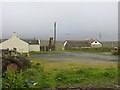
Iron Age and Later PrehistorySite Name: Hamnavoe BrochCountry: Scotland County: Shetland Type: Broch or Nuraghe
Map Ref: HU2389380641
Latitude: 60.508703N Longitude: 1.566781W
Condition:
| 5 | Perfect |
| 4 | Almost Perfect |
| 3 | Reasonable but with some damage |
| 2 | Ruined but still recognisable as an ancient site |
| 1 | Pretty much destroyed, possibly visible as crop marks |
| 0 | No data. |
| -1 | Completely destroyed |
| 5 | Superb |
| 4 | Good |
| 3 | Ordinary |
| 2 | Not Good |
| 1 | Awful |
| 0 | No data. |
| 5 | Can be driven to, probably with disabled access |
| 4 | Short walk on a footpath |
| 3 | Requiring a bit more of a walk |
| 2 | A long walk |
| 1 | In the middle of nowhere, a nightmare to find |
| 0 | No data. |
| 5 | co-ordinates taken by GPS or official recorded co-ordinates |
| 4 | co-ordinates scaled from a detailed map |
| 3 | co-ordinates scaled from a bad map |
| 2 | co-ordinates of the nearest village |
| 1 | co-ordinates of the nearest town |
| 0 | no data |
Internal Links:
External Links:
Broch or in Shetland
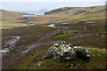
Remains of a broch with outworks located on a grassy knoll. Remains of the intra-mural cell are visible in NE part of the broch. Remains of the defensive bank are still distinguishable.
Reference:
MacKie, E.W. 2002.The Roundhouses, Brochs and Wheelhouses of Atlantic Scotland c. 700 BC - 500 AD. Part 1: The Orkney and Shetland Isles. Oxford: Archaeopress.
You may be viewing yesterday's version of this page. To see the most up to date information please register for a free account.
Do not use the above information on other web sites or publications without permission of the contributor.
davidmorgan has found this location on Google Street View:
Nearby Images from Geograph Britain and Ireland:
©2014(licence)
©2011(licence)
©2016(licence)
©2012(licence)
©2013(licence)
The above images may not be of the site on this page, they are loaded from Geograph.
Please Submit an Image of this site or go out and take one for us!
Click here to see more info for this site
Nearby sites
Key: Red: member's photo, Blue: 3rd party photo, Yellow: other image, Green: no photo - please go there and take one, Grey: site destroyed
Download sites to:
KML (Google Earth)
GPX (GPS waypoints)
CSV (Garmin/Navman)
CSV (Excel)
To unlock full downloads you need to sign up as a Contributory Member. Otherwise downloads are limited to 50 sites.
Turn off the page maps and other distractions
Nearby sites listing. In the following links * = Image available
426m ESE 102° Giant's Stones (Shetland)* Standing Stones (HU2431280555)
429m ESE 110° Giant's Stones Row (Shetland)* Multiple Stone Rows / Avenue (HU243805)
2.9km WSW 240° Loch of Houlland* Broch or Nuraghe (HU2140079160)
3.6km SW 224° Loch of Breckon Burnt Mound* Artificial Mound (HU21437803)
3.9km SW 228° Sae Breck* Broch or Nuraghe (HU21057803)
4.7km ESE 119° Burnside Burnt Mound* Artificial Mound (HU28057842)
5.8km ESE 116° Gateside Chambered Cairn* Chambered Cairn (HU29137811)
12.7km SE 138° Pund's Water* Chambered Cairn (HU32457124)
12.9km NE 43° Beorgs of Uyea neolithic axe factory* Ancient Mine, Quarry or other Industry (HU3268990052)
12.9km NE 44° Beorgs of Uyea chambered cairn* Chambered Cairn (HU3278890043)
13.1km ENE 69° Beorgs of Housetter* Standing Stones (HU36178546)
13.2km ENE 69° Trowie Knowe* Chambered Cairn (HU36208552)
15.5km SE 142° Islesburgh* Chambered Cairn (HU33456845)
17.2km SE 141° Busta Brae* Standing Stones (HU34886739)
18.7km ESE 106° Crooksetter Hill - two Chambered Cairns* Chambered Cairn (HU420756)
20.5km SSE 164° Vementry* Chambered Cairn (HU296609)
21.6km ENE 69° West Sandwick* Broch or Nuraghe (HU440887)
22.2km SSW 199° Doom Rings Stone Circle (HU166596)
22.4km S 186° Ness of Garth* Promontory Fort / Cliff Castle (HU216583)
22.4km SSW 198° Papa Stour Chambered Cairn (HU17025924)
22.5km SSW 192° Holm of Melby NE Chambered Cairn (HU19315856)
22.5km S 186° Bay of Garth Broch or Nuraghe (HU216582)
22.5km SSW 192° Holm of Melby NW Cairn (HU19195856)
22.6km SSW 192° Holm of Melby South Cairn (HU19225851)
23.2km S 184° Broch of Brousta Broch or Nuraghe (HU223575)
View more nearby sites and additional images


 We would like to know more about this location. Please feel free to add a brief description and any relevant information in your own language.
 Wir möchten mehr über diese Stätte erfahren. Bitte zögern Sie nicht, eine kurze Beschreibung und relevante Informationen in Deutsch hinzuzufügen.
 Nous aimerions en savoir encore un peu sur les lieux. S'il vous plaît n'hesitez pas à ajouter une courte description et tous les renseignements pertinents dans votre propre langue.
 Quisieramos informarnos un poco más de las lugares. No dude en añadir una breve descripción y otros datos relevantes en su propio idioma.