

<< Our Photo Pages >> Carrowmore 26 - Stone Circle in Ireland (Republic of) in Co. Sligo
Submitted by Tom_Bullock on Sunday, 14 July 2002 Page Views: 5921
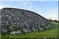
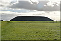
Neolithic and Bronze AgeSite Name: Carrowmore 26Country: Ireland (Republic of) County: Co. Sligo Type: Stone Circle
Map Ref: G6658233284
Discovery Map Number: D25
Latitude: 54.247359N Longitude: 8.513382W
Condition:
| 5 | Perfect |
| 4 | Almost Perfect |
| 3 | Reasonable but with some damage |
| 2 | Ruined but still recognisable as an ancient site |
| 1 | Pretty much destroyed, possibly visible as crop marks |
| 0 | No data. |
| -1 | Completely destroyed |
| 5 | Superb |
| 4 | Good |
| 3 | Ordinary |
| 2 | Not Good |
| 1 | Awful |
| 0 | No data. |
| 5 | Can be driven to, probably with disabled access |
| 4 | Short walk on a footpath |
| 3 | Requiring a bit more of a walk |
| 2 | A long walk |
| 1 | In the middle of nowhere, a nightmare to find |
| 0 | No data. |
| 5 | co-ordinates taken by GPS or official recorded co-ordinates |
| 4 | co-ordinates scaled from a detailed map |
| 3 | co-ordinates scaled from a bad map |
| 2 | co-ordinates of the nearest village |
| 1 | co-ordinates of the nearest town |
| 0 | no data |
Internal Links:
External Links:
")
Have you visited this site? Please add a comment below.
You may be viewing yesterday's version of this page. To see the most up to date information please register for a free account.
")
")
")
")
Do not use the above information on other web sites or publications without permission of the contributor.
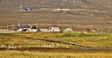
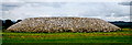
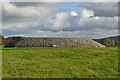
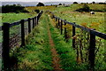
Nearby Images from Geograph Britain and Ireland:
©2010(licence)
©2022(licence)
©2009(licence)
©2022(licence)
©2022(licence)
The above images may not be of the site on this page, they are loaded from Geograph.
Please Submit an Image of this site or go out and take one for us!
Click here to see more info for this site
Nearby sites
Click here to view sites on an interactive map of the areaKey: Red: member's photo, Blue: 3rd party photo, Yellow: other image, Green: no photo - please go there and take one, Grey: site destroyed
Download sites to:
KML (Google Earth)
GPX (GPS waypoints)
CSV (Garmin/Navman)
CSV (Excel)
To unlock full downloads you need to sign up as a Contributory Member. Otherwise downloads are limited to 50 sites.
Turn off the page maps and other distractions
Nearby sites listing. In the following links * = Image available
65m WSW 250° Carrowmore 27* Passage Grave
84m N 8° Carrowmore Cairn 22* Passage Grave
96m NNW 348° Carrowmore Cairn 21* Passage Grave
124m NNW 345° Carrowmore Cairn 20* Passage Grave
296m NNW 346° Carrowmore 18* Passage Grave
321m NNW 343° Carrowmore Cairn 17* Passage Grave
368m WNW 295° Carrowmore 51 (Listoghil)* Passage Grave (G6624833442)
404m NW 312° Carrowmore 57* Stone Circle (G6628133555)
407m NW 324° Carrowmore 59* Burial Chamber or Dolmen (G6634333614)
408m NW 308° Carrowmore 56* Passage Grave (G6626033537)
409m NW 321° Carrowmore 58* Passage Grave (G6632833605)
434m W 271° Carrowmore 48* Passage Grave (G6614733297)
435m NNW 338° Carrowmore Cairn 15* Passage Grave
488m NNW 333° Carrowmore Well* Holy Well or Sacred Spring
493m WNW 296° Carrowmore 52* Passage Grave (G6613833502)
506m WNW 302° Carrowmore 54* Passage Grave (G6615433556)
522m WNW 295° Carrowmore 52a* Passage Grave (G6610833507)
533m WNW 299° Carrowmore 53* Chambered Tomb (G6611433542)
542m NW 312° Carrowmore* Passage Grave (G66183365)
551m NNW 341° Carrowmore 13* Burial Chamber or Dolmen
569m WNW 303° Carrowmore 55* Passage Grave
577m NW 320° Carrowmore 4.* Passage Grave (G6621133727)
582m NW 315° Carrowmore 2.* Passage Grave (G6617433701)
585m NW 325° Carrowmore 5.* Passage Grave (G6625233768)
586m NW 314° Carrowmore 1.* Passage Grave (G6616033692)
View more nearby sites and additional images


 We would like to know more about this location. Please feel free to add a brief description and any relevant information in your own language.
 Wir möchten mehr über diese Stätte erfahren. Bitte zögern Sie nicht, eine kurze Beschreibung und relevante Informationen in Deutsch hinzuzufügen.
 Nous aimerions en savoir encore un peu sur les lieux. S'il vous plaît n'hesitez pas à ajouter une courte description et tous les renseignements pertinents dans votre propre langue.
 Quisieramos informarnos un poco más de las lugares. No dude en añadir una breve descripción y otros datos relevantes en su propio idioma.