<< Our Photo Pages >> Clachadow - Cairn in Scotland in Argyll
Submitted by caradoc68 on Sunday, 05 February 2012 Page Views: 2651
Neolithic and Bronze AgeSite Name: ClachadowCountry: Scotland County: Argyll Type: Cairn
Nearest Town: Oban Nearest Village: Taynuilt
Map Ref: NM93932806
Latitude: 56.399709N Longitude: 5.34088W
Condition:
| 5 | Perfect |
| 4 | Almost Perfect |
| 3 | Reasonable but with some damage |
| 2 | Ruined but still recognisable as an ancient site |
| 1 | Pretty much destroyed, possibly visible as crop marks |
| 0 | No data. |
| -1 | Completely destroyed |
| 5 | Superb |
| 4 | Good |
| 3 | Ordinary |
| 2 | Not Good |
| 1 | Awful |
| 0 | No data. |
| 5 | Can be driven to, probably with disabled access |
| 4 | Short walk on a footpath |
| 3 | Requiring a bit more of a walk |
| 2 | A long walk |
| 1 | In the middle of nowhere, a nightmare to find |
| 0 | No data. |
| 5 | co-ordinates taken by GPS or official recorded co-ordinates |
| 4 | co-ordinates scaled from a detailed map |
| 3 | co-ordinates scaled from a bad map |
| 2 | co-ordinates of the nearest village |
| 1 | co-ordinates of the nearest town |
| 0 | no data |
Internal Links:
External Links:
I have visited· I would like to visit
hidebasket visited on 19th Feb 2023 - their rating: Cond: 2 Amb: 4 Access: 4
")
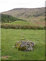
Near the north bank of the River Lonan, are the remains of a cairn, now grass grown and measuring 18.3 metres in diameter and 1.9 metres in height. There is a shallow depression in the centre which contains, embedded in the turf, a flat slab measuring 1.22 by 0.76 metres and at least 0.15 metres in thickness. This slab was raised in the 1870s when it was confirmed as being the capstone of a cist which measured internally 0.91 by 0.50 and was 0.63 metres in depth. This cist was found to be filled with earth in which a few small fragments of human bone were found, but there were no grave goods of any kind.
RCAHMS 1975, visited 1969.
You may be viewing yesterday's version of this page. To see the most up to date information please register for a free account.
Do not use the above information on other web sites or publications without permission of the contributor.
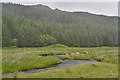
Nearby Images from Geograph Britain and Ireland:
©2008(licence)
©2008(licence)
©2012(licence)
©2011(licence)
©2017(licence)
The above images may not be of the site on this page, they are loaded from Geograph.
Please Submit an Image of this site or go out and take one for us!
Click here to see more info for this site
Nearby sites
Key: Red: member's photo, Blue: 3rd party photo, Yellow: other image, Green: no photo - please go there and take one, Grey: site destroyed
Download sites to:
KML (Google Earth)
GPX (GPS waypoints)
CSV (Garmin/Navman)
CSV (Excel)
To unlock full downloads you need to sign up as a Contributory Member. Otherwise downloads are limited to 50 sites.
Turn off the page maps and other distractions
Nearby sites listing. In the following links * = Image available
1.1km WNW 283° Glenamacrie Dun* Stone Fort or Dun (NM92862836)
1.5km WNW 286° Clenamacrie Stone Row* Stone Row / Alignment (NM9251128550)
1.6km WNW 285° Glenamacrie Farm* Cairn (NM92452854)
1.9km WNW 287° Glenamachrie Cairn* Cairn (NM92132870)
3.3km WNW 283° Diarmid's Grave* Cairn (NM9077828950)
3.3km WNW 283° Clach na Carraig* Standing Stone (Menhir) (NM9076728957)
3.3km WNW 285° Strontoiller Large Cairn* Cairn (NM90732907)
3.4km WNW 286° Strontoiller circle* Stone Circle (NM90672914)
4.0km NW 320° Kilvaree standing stone* Standing Stone (Menhir) (NM91553124)
4.1km W 267° Rubha Na Moine* Crannog (NM89812807)
4.5km W 271° Skull Shaped Stone - Loch Nell* Natural Stone / Erratic / Other Natural Feature (NM8939628383)
4.9km SSW 212° Dun Iadain* Stone Fort or Dun (NM91122404)
5.4km SW 223° Dalnacabaig* Cairn (NM90002429)
5.7km WSW 253° Barnacarry* Crannog (NM88362662)
5.9km W 260° Killiechonich* Rock Art (NM88082736)
6.0km WSW 255° Dalinaneun Farm Cairn 3 Cairn (NM880268)
6.0km WSW 255° Serpent Mound - Loch Nell* Artificial Mound (NM880268)
6.1km WSW 254° Dalineun* Chambered Tomb (NM8799326710)
6.1km WSW 251° Moleigh* Cairn (NM88082631)
6.1km WSW 249° Possible cairn at Kilmore* Cairn (NM88092609)
6.1km WSW 248° Cleigh* Misc. Earthwork (NM88112602)
6.2km WSW 248° Dalinaneun Farm Cairn 2* Cairn (NM881260)
6.3km WSW 240° Kilmore House* Cairn (NM88292515)
6.4km WSW 242° Kilmore Cairn* Cairn (NM88172533)
6.4km NNW 337° Connel Station (Oban) Standing Stone (Menhir) (NM91693408)
View more nearby sites and additional images


 We would like to know more about this location. Please feel free to add a brief description and any relevant information in your own language.
 Wir möchten mehr über diese Stätte erfahren. Bitte zögern Sie nicht, eine kurze Beschreibung und relevante Informationen in Deutsch hinzuzufügen.
 Nous aimerions en savoir encore un peu sur les lieux. S'il vous plaît n'hesitez pas à ajouter une courte description et tous les renseignements pertinents dans votre propre langue.
 Quisieramos informarnos un poco más de las lugares. No dude en añadir una breve descripción y otros datos relevantes en su propio idioma.