


<< Our Photo Pages >> Henderland Hill - Hillfort in Scotland in Scottish Borders
Submitted by h_fenton on Saturday, 10 September 2011 Page Views: 7681
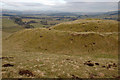
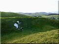
Iron Age and Later PrehistorySite Name: Henderland HillCountry: Scotland County: Scottish Borders Type: Hillfort
Nearest Town: Peebles Nearest Village: Blyth Bridge
Map Ref: NT14964597
Latitude: 55.699699N Longitude: 3.354622W
Condition:
| 5 | Perfect |
| 4 | Almost Perfect |
| 3 | Reasonable but with some damage |
| 2 | Ruined but still recognisable as an ancient site |
| 1 | Pretty much destroyed, possibly visible as crop marks |
| 0 | No data. |
| -1 | Completely destroyed |
| 5 | Superb |
| 4 | Good |
| 3 | Ordinary |
| 2 | Not Good |
| 1 | Awful |
| 0 | No data. |
| 5 | Can be driven to, probably with disabled access |
| 4 | Short walk on a footpath |
| 3 | Requiring a bit more of a walk |
| 2 | A long walk |
| 1 | In the middle of nowhere, a nightmare to find |
| 0 | No data. |
| 5 | co-ordinates taken by GPS or official recorded co-ordinates |
| 4 | co-ordinates scaled from a detailed map |
| 3 | co-ordinates scaled from a bad map |
| 2 | co-ordinates of the nearest village |
| 1 | co-ordinates of the nearest town |
| 0 | no data |
Be the first person to rate this site - see the 'Contribute!' box in the right hand menu.
Internal Links:
External Links:
I have visited· I would like to visit
h_fenton has visited here
")
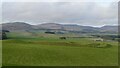
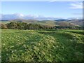
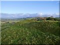
The fort has far reaching views, particular to the north and northwest.
Access: there is a signed and waymarked path to the hillfort from the minor road that passes to the northeast of the fort (from NT 1533 4628).
For further information see ScotlandsPlaces: www.scotlandsplaces.gov.uk/search_item/index.php?service=RCAHMS&id=50030
You may be viewing yesterday's version of this page. To see the most up to date information please register for a free account.
")
")
Do not use the above information on other web sites or publications without permission of the contributor.
Nearby Images from Geograph Britain and Ireland:
©2021(licence)
©2010(licence)
©2021(licence)
©2021(licence)
©2021(licence)
The above images may not be of the site on this page, they are loaded from Geograph.
Please Submit an Image of this site or go out and take one for us!
Click here to see more info for this site
Nearby sites
Key: Red: member's photo, Blue: 3rd party photo, Yellow: other image, Green: no photo - please go there and take one, Grey: site destroyed
Download sites to:
KML (Google Earth)
GPX (GPS waypoints)
CSV (Garmin/Navman)
CSV (Excel)
To unlock full downloads you need to sign up as a Contributory Member. Otherwise downloads are limited to 50 sites.
Turn off the page maps and other distractions
Nearby sites listing. In the following links * = Image available
3.0km SW 236° Harestanes (Kirkurd)* Stone Circle (NT12404432)
3.6km W 264° Shaw Hill (Kirkurd) Misc. Earthwork (NT11334564)
4.9km ESE 106° Harehope Rings* Hillfort (NT1962644573)
4.9km WSW 246° Netherurd Mains (Kirkurd) Ancient Cross (NT10414403)
6.9km ESE 110° Green Knowe Round Cairn (NT21384351)
7.1km ESE 114° Druids Circle (Eddleston)* Henge (NT21404290)
7.1km WNW 292° Dunsyre cup and ring marked stone* Rock Art (NT084488)
7.4km WSW 253° Howburn Farm Ancient Village or Settlement (NT078440)
7.6km ESE 113° White Meldon* Round Cairn (NT21894284)
7.8km SE 138° Sheriff Muir Standing Stones* Standing Stones (NT20094005)
7.8km SE 134° Meldon Bridge Timber Circle (NT205404)
8.9km SSE 157° Stobo Kirk standing stone* Standing Stone (Menhir) (NT1826037655)
10.3km S 175° Altar Stone, Stobo* Standing Stone (Menhir) (NT15703573)
10.6km S 184° Drumelzier Haugh* Standing Stone (Menhir) (NT13933542)
10.6km S 190° Dreva Hill West (Broughton)* Ancient Village or Settlement (NT12923553)
10.6km SE 132° Kirkton Manor* Standing Stone (Menhir) (NT22693863)
10.8km SSW 192° Dreva Craig* Standing Stone (Menhir) (NT12453545)
10.9km S 191° Dreva Craig* Hillfort (NT12673533)
11.1km W 267° Tod Holes (Weston) Sculptured Stone (NT03844560)
11.3km ENE 71° Northshield Rings* Hillfort (NT25734934)
11.4km SSW 199° Helm End Hillfort (NT10983532)
11.5km S 183° Tinnis Castle* Hillfort (NT14153444)
11.6km SE 139° Cademuir Hill* Hillfort (NT22473708)
11.9km W 268° Weston henge* Henge (NT03004578)
12.0km ESE 117° Whitestone (Peebles)* Marker Stone (NT256404)
View more nearby sites and additional images


 We would like to know more about this location. Please feel free to add a brief description and any relevant information in your own language.
 Wir möchten mehr über diese Stätte erfahren. Bitte zögern Sie nicht, eine kurze Beschreibung und relevante Informationen in Deutsch hinzuzufügen.
 Nous aimerions en savoir encore un peu sur les lieux. S'il vous plaît n'hesitez pas à ajouter une courte description et tous les renseignements pertinents dans votre propre langue.
 Quisieramos informarnos un poco más de las lugares. No dude en añadir una breve descripción y otros datos relevantes en su propio idioma.