


<< Text Pages >> Anulu Insediamento Nuragico - Ancient Village or Settlement in Italy in Sardinia (Sardegna)
Submitted by SolarMegalith on Wednesday, 29 December 2010 Page Views: 1937
Multi-periodSite Name: Anulu Insediamento NuragicoCountry: Italy Region: Sardinia (Sardegna) Type: Ancient Village or Settlement
Nearest Town: Ussassai
Latitude: 39.854080N Longitude: 9.378810E
Condition:
| 5 | Perfect |
| 4 | Almost Perfect |
| 3 | Reasonable but with some damage |
| 2 | Ruined but still recognisable as an ancient site |
| 1 | Pretty much destroyed, possibly visible as crop marks |
| 0 | No data. |
| -1 | Completely destroyed |
| 5 | Superb |
| 4 | Good |
| 3 | Ordinary |
| 2 | Not Good |
| 1 | Awful |
| 0 | No data. |
| 5 | Can be driven to, probably with disabled access |
| 4 | Short walk on a footpath |
| 3 | Requiring a bit more of a walk |
| 2 | A long walk |
| 1 | In the middle of nowhere, a nightmare to find |
| 0 | No data. |
| 5 | co-ordinates taken by GPS or official recorded co-ordinates |
| 4 | co-ordinates scaled from a detailed map |
| 3 | co-ordinates scaled from a bad map |
| 2 | co-ordinates of the nearest village |
| 1 | co-ordinates of the nearest town |
| 0 | no data |
Internal Links:
External Links:
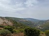
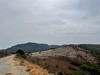
Ancient Village or Settlement in Sardinia (Sardegna)
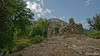
Remains of nuragic settlement NE from Nuraghe Anulu.
You may be viewing yesterday's version of this page. To see the most up to date information please register for a free account.
Do not use the above information on other web sites or publications without permission of the contributor.
Nearby Images from Flickr


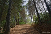
The above images may not be of the site on this page, but were taken nearby. They are loaded from Flickr so please click on them for image credits.
Click here to see more info for this site
Nearby sites
Click here to view sites on an interactive map of the areaKey: Red: member's photo, Blue: 3rd party photo, Yellow: other image, Green: no photo - please go there and take one, Grey: site destroyed
Download sites to:
KML (Google Earth)
GPX (GPS waypoints)
CSV (Garmin/Navman)
CSV (Excel)
To unlock full downloads you need to sign up as a Contributory Member. Otherwise downloads are limited to 50 sites.
Turn off the page maps and other distractions
Nearby sites listing. In the following links * = Image available
121m WSW 245° Anulu Nuraghe Broch or Nuraghe
4.2km S 178° Useligis Nuraghe Broch or Nuraghe
4.7km NW 318° Pauli Nuraghe (Seui)* Broch or Nuraghe
5.0km NNW 333° Mercussei Fonte Nuragica* Holy Well or Sacred Spring
5.5km NW 322° Ardasai Nuraghe* Broch or Nuraghe
5.5km NW 319° Ardasai Tomba di Giganti* Chambered Tomb
7.1km E 98° Serbissi Grotta* Cave or Rock Shelter
7.1km E 98° Serbissi Nuraghe* Broch or Nuraghe
8.0km SSE 156° Is Coccoronis Nuraghe Broch or Nuraghe
8.2km S 171° Arcu Addai Nuraghe Broch or Nuraghe
8.6km ESE 119° Sanu Nuraghe (Osini)* Broch or Nuraghe
8.8km ESE 115° Orruttu Nuraghe* Broch or Nuraghe
9.2km WNW 285° Su Forreddu 'e Lareri Domus de Janas* Rock Cut Tomb
10.0km W 274° Is Janas* Cave or Rock Shelter
10.6km WSW 249° Casteddos de Seddori Nuraghe Broch or Nuraghe
11.5km W 268° Taccu 'e Ticci Tomba di Giganti* Chambered Tomb
11.6km W 265° Perda Lada Domus de Janas* Rock Cut Tomb
12.1km W 270° Taccu 'e Ticci Nuraghe* Broch or Nuraghe
12.2km SSW 211° Recinto megalitico di Santa Vittoria* Ancient Village or Settlement
12.3km ENE 78° Seleni II Tomba di Giganti* Chambered Tomb
12.3km ENE 78° Seleni I Tomba di Giganti* Chambered Tomb
12.5km W 273° Nuraxeddu Nuraghe* Broch or Nuraghe
12.5km E 80° Gennaccili Nuraghe e Villaggio Nuragico* Broch or Nuraghe
12.7km W 274° Pauli Nuraghe (Seulo)* Broch or Nuraghe
12.9km SSW 198° Domu'e Orxia Tempio Nuragico* Ancient Temple
View more nearby sites and additional images


 We would like to know more about this location. Please feel free to add a brief description and any relevant information in your own language.
 Wir möchten mehr über diese Stätte erfahren. Bitte zögern Sie nicht, eine kurze Beschreibung und relevante Informationen in Deutsch hinzuzufügen.
 Nous aimerions en savoir encore un peu sur les lieux. S'il vous plaît n'hesitez pas à ajouter une courte description et tous les renseignements pertinents dans votre propre langue.
 Quisieramos informarnos un poco más de las lugares. No dude en añadir una breve descripción y otros datos relevantes en su propio idioma.