<< Our Photo Pages >> Kraiknish - Stone Fort or Dun in Scotland in Isle of Skye
Submitted by Andy B on Tuesday, 19 October 2010 Page Views: 3935
Multi-periodSite Name: KraiknishCountry: Scotland County: Isle of Skye Type: Stone Fort or Dun
Map Ref: NG35462340
Latitude: 57.224649N Longitude: 6.384435W
Condition:
| 5 | Perfect |
| 4 | Almost Perfect |
| 3 | Reasonable but with some damage |
| 2 | Ruined but still recognisable as an ancient site |
| 1 | Pretty much destroyed, possibly visible as crop marks |
| 0 | No data. |
| -1 | Completely destroyed |
| 5 | Superb |
| 4 | Good |
| 3 | Ordinary |
| 2 | Not Good |
| 1 | Awful |
| 0 | No data. |
| 5 | Can be driven to, probably with disabled access |
| 4 | Short walk on a footpath |
| 3 | Requiring a bit more of a walk |
| 2 | A long walk |
| 1 | In the middle of nowhere, a nightmare to find |
| 0 | No data. |
| 5 | co-ordinates taken by GPS or official recorded co-ordinates |
| 4 | co-ordinates scaled from a detailed map |
| 3 | co-ordinates scaled from a bad map |
| 2 | co-ordinates of the nearest village |
| 1 | co-ordinates of the nearest town |
| 0 | no data |
Be the first person to rate this site - see the 'Contribute!' box in the right hand menu.
Internal Links:
External Links:
")
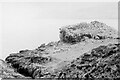
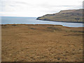
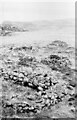
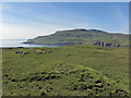
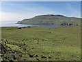
On an elevated rock, rising about 50ft above the water, on the S side of the mouth of Loch Eynort, about 1 mile W of Kraiknish, is a ruined dun. On the flanks the rock has a height of about 25ft, and on the landward side towards the SE it is about 15ft high and is approached by a steep slope. The defences consist of a stone wall built on the edge of the rock, and an outer wall built on the slope towards the land with its ends resting on the rocks on the flanks.
The inner wall, enclosing a rounded triangular space, measuring some 56ft NE-SW and some 52ft from NW-SE internally, has almost disappeared on the sides next the sea, but on the landward side it shows an inner face rising about 4ft above the interior, and the outer face standing to a height of 7ft on the S, the remaining section being for the greater part hidden by tumbled stones. At its widest part it is 10ft 9ins thick, but it attenuates as it curves back and merges into the side walls. The outer face of the outer wall, showing 3ft of building at most in position, stands 19ft from, and apparently about 8ft lower than, the inner wall. The roadway into the dun lies towards the S end of the outer wall, which curves inwards at the entrance. The wall on the left side is broken down, but the entrance seems to have been about 4ft wide. The roadway slants to the left and enters the enceinte through an inner entrance, also broken down, about 4ft 4ins wide.
Source: Canmore
You may be viewing yesterday's version of this page. To see the most up to date information please register for a free account.
")
")
")
")
Do not use the above information on other web sites or publications without permission of the contributor.
Nearby Images from Geograph Britain and Ireland:
©2021(licence)
©2008(licence)
©2021(licence)
©2014(licence)
©2014(licence)
The above images may not be of the site on this page, they are loaded from Geograph.
Please Submit an Image of this site or go out and take one for us!
Click here to see more info for this site
Nearby sites
Key: Red: member's photo, Blue: 3rd party photo, Yellow: other image, Green: no photo - please go there and take one, Grey: site destroyed
Download sites to:
KML (Google Earth)
GPX (GPS waypoints)
CSV (Garmin/Navman)
CSV (Excel)
To unlock full downloads you need to sign up as a Contributory Member. Otherwise downloads are limited to 50 sites.
Turn off the page maps and other distractions
Nearby sites listing. In the following links * = Image available
6.6km NNW 328° Dun Sleadale* Broch or Nuraghe (NG323292)
8.0km NNE 22° Dun Merkadale* Stone Fort or Dun (NG38983061)
8.0km SSE 148° Rubh' an Dunain Cairn* Chambered Cairn (NG39341636)
8.5km SSE 147° Rubh' an Dunain Broch* Broch or Nuraghe (NG39581597)
10.6km NNW 327° Cave of the Speckled Horses Cave or Rock Shelter (NG30283264)
11.1km N 351° Crois Mic Jamain Standing Stones (NG345345)
12.5km NNW 347° Dun Ardtreck* Broch or Nuraghe (NG335358)
13.2km N 360° Dun Taimh* Stone Fort or Dun (NG363366)
14.3km N 349° Struanmore* Chambered Cairn (NG337376)
14.4km ENE 73° River Sligachan Stone Circle (NG49582662)
14.7km NNW 344° Ullinish Lodge* Chambered Cairn (NG323378)
14.7km N 356° Dun Diarmaid* Broch or Nuraghe (NG35453816)
15.2km NNW 349° Ullinish Souterrain Souterrain (Fogou, Earth House) (NG334385)
15.3km N 351° Dun Beag (Struan)* Broch or Nuraghe (NG3395438630)
15.4km N 359° Dun Garsin* Broch or Nuraghe (NG361388)
15.6km N 351° Dun Mor (Struan)* Stone Fort or Dun (NG340390)
17.4km NNE 13° Tungadal* Souterrain (Fogou, Earth House) (NG404401)
18.8km ESE 115° Raven's Stone (Elgol) Standing Stone (Menhir) (NG520144)
18.8km NNW 333° Dun Neill* Stone Fort or Dun (NG28114073)
19.2km N 355° Dun Arkaig* Broch or Nuraghe (NG350426)
19.5km E 98° Abhainn Cille Mhaire Standing Stones (NG54611952)
19.6km NNW 343° Dun Abhuinn Bhaile Mheadhonaich* Stone Fort or Dun (NG309425)
19.7km ESE 103° Na Clachan Bhreige* Stone Circle (NG5433817681)
19.7km NNW 340° Dun Feorlig* Broch or Nuraghe (NG299423)
19.8km ESE 102° Kilmarie Standing Stones (NG54591814)
View more nearby sites and additional images


 We would like to know more about this location. Please feel free to add a brief description and any relevant information in your own language.
 Wir möchten mehr über diese Stätte erfahren. Bitte zögern Sie nicht, eine kurze Beschreibung und relevante Informationen in Deutsch hinzuzufügen.
 Nous aimerions en savoir encore un peu sur les lieux. S'il vous plaît n'hesitez pas à ajouter une courte description et tous les renseignements pertinents dans votre propre langue.
 Quisieramos informarnos un poco más de las lugares. No dude en añadir una breve descripción y otros datos relevantes en su propio idioma.