

<< Our Photo Pages >> Maruyama Hachiman Jinja shrine - Standing Stones in Japan in Shikoku
Submitted by Aska on Friday, 15 October 2010 Page Views: 3068
Early Medieval (Dark Age)Site Name: Maruyama Hachiman Jinja shrine Alternative Name: 丸山八幡神社Country: Japan Region: Shikoku Type: Standing Stones
Nearest Town: Mima (Tokushima pref.) Nearest Village: Anabukichō-Maruyama 穴吹
Latitude: 34.020870N Longitude: 134.154600E
Condition:
| 5 | Perfect |
| 4 | Almost Perfect |
| 3 | Reasonable but with some damage |
| 2 | Ruined but still recognisable as an ancient site |
| 1 | Pretty much destroyed, possibly visible as crop marks |
| 0 | No data. |
| -1 | Completely destroyed |
| 5 | Superb |
| 4 | Good |
| 3 | Ordinary |
| 2 | Not Good |
| 1 | Awful |
| 0 | No data. |
| 5 | Can be driven to, probably with disabled access |
| 4 | Short walk on a footpath |
| 3 | Requiring a bit more of a walk |
| 2 | A long walk |
| 1 | In the middle of nowhere, a nightmare to find |
| 0 | No data. |
| 5 | co-ordinates taken by GPS or official recorded co-ordinates |
| 4 | co-ordinates scaled from a detailed map |
| 3 | co-ordinates scaled from a bad map |
| 2 | co-ordinates of the nearest village |
| 1 | co-ordinates of the nearest town |
| 0 | no data |
Internal Links:
External Links:
")
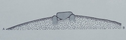
Down in a valley in a solitary Maruyama (丸山) hamlet, a small wood of shrine floating in a tea field. In the wood, a new shrine is surrounded by standing stones like Shirayamahime Jinja shrine.
A shine gate (34.02087N,134.15646E) standing on the road side far from the shrine's wood has also accompanying standing stones.
You may be viewing yesterday's version of this page. To see the most up to date information please register for a free account.
")
")
Do not use the above information on other web sites or publications without permission of the contributor.
Nearby Images from Flickr
The above images may not be of the site on this page, but were taken nearby. They are loaded from Flickr so please click on them for image credits.
Click here to see more info for this site
Nearby sites
Click here to view sites on an interactive map of the areaKey: Red: member's photo, Blue: 3rd party photo, Yellow: other image, Green: no photo - please go there and take one, Grey: site destroyed
Download sites to:
KML (Google Earth)
GPX (GPS waypoints)
CSV (Garmin/Navman)
CSV (Excel)
To unlock full downloads you need to sign up as a Contributory Member. Otherwise downloads are limited to 50 sites.
Turn off the page maps and other distractions
Nearby sites listing. In the following links * = Image available
1.5km S 189° Shirahito Jinja-no Shishiseki* Standing Stones
1.7km SSW 198° Shinmei Jinja shrine* Misc. Earthwork
1.8km SSW 194° Tagata* Standing Stones
2.2km SSW 191° Shichijinseki* Stone Row / Alignment
2.4km NNE 13° Hirano-no Tateishi* Standing Stones
3.0km W 273° Fuchimyō* Standing Stone (Menhir)
3.3km WSW 253° Shinō* Stone Row / Alignment
5.8km N 352° Tōrin-ji temple* Modern Stone Circle etc
6.1km SW 235° Chichibushan Taki* Stone Row / Alignment
6.5km WSW 255° Tateishiyama* Stone Row / Alignment
7.8km E 92° Kamisuki Jinja shrine* Standing Stone (Menhir)
7.8km W 276° Ōizumi-dō* Standing Stone (Menhir)
8.1km WSW 249° Kiradō* Standing Stones
8.5km WNW 282° Higashiura* Standing Stone (Menhir)
8.6km ENE 77° Akaiwa Shōgen* Misc. Earthwork
8.7km W 281° Nagai Family Residence garden* Modern Stone Circle etc
9.0km ENE 65° Aogi-no Dankonseki* Standing Stones
9.1km E 80° Hakeishi* Standing Stone (Menhir)
9.2km S 181° Ishio Jinja shrine* Stone Row / Alignment
9.4km WNW 282° Nishiyama Kofun (in Tokushima)* Standing Stone (Menhir)
9.4km WNW 291° Ganshō-ji temple* Modern Stone Circle etc
9.5km E 94° Ofunattsan* Misc. Earthwork
9.8km E 93° Yambashira* Standing Stones
9.9km E 82° Nara-no-ki* Standing Stone (Menhir)
10.0km ENE 71° Shirayamahime Jinja shrine* Standing Stones
View more nearby sites and additional images


 We would like to know more about this location. Please feel free to add a brief description and any relevant information in your own language.
 Wir möchten mehr über diese Stätte erfahren. Bitte zögern Sie nicht, eine kurze Beschreibung und relevante Informationen in Deutsch hinzuzufügen.
 Nous aimerions en savoir encore un peu sur les lieux. S'il vous plaît n'hesitez pas à ajouter une courte description et tous les renseignements pertinents dans votre propre langue.
 Quisieramos informarnos un poco más de las lugares. No dude en añadir una breve descripción y otros datos relevantes en su propio idioma.