

<< Our Photo Pages >> Kyōgakuma - Chambered Cairn in Japan in Kyūshū
Submitted by Aska on Monday, 10 May 2010 Page Views: 2101
Neolithic and Bronze AgeSite Name: Kyōgakuma Alternative Name: 経隈 KyogakumaCountry: Japan Region: Kyūshū Type: Chambered Cairn
Nearest Town: Tsushima (Nagasaki pref.) Nearest Village: Kamitsushimachō-Kawachi 上
Latitude: 34.676160N Longitude: 129.429030E
Condition:
| 5 | Perfect |
| 4 | Almost Perfect |
| 3 | Reasonable but with some damage |
| 2 | Ruined but still recognisable as an ancient site |
| 1 | Pretty much destroyed, possibly visible as crop marks |
| 0 | No data. |
| -1 | Completely destroyed |
| 5 | Superb |
| 4 | Good |
| 3 | Ordinary |
| 2 | Not Good |
| 1 | Awful |
| 0 | No data. |
| 5 | Can be driven to, probably with disabled access |
| 4 | Short walk on a footpath |
| 3 | Requiring a bit more of a walk |
| 2 | A long walk |
| 1 | In the middle of nowhere, a nightmare to find |
| 0 | No data. |
| 5 | co-ordinates taken by GPS or official recorded co-ordinates |
| 4 | co-ordinates scaled from a detailed map |
| 3 | co-ordinates scaled from a bad map |
| 2 | co-ordinates of the nearest village |
| 1 | co-ordinates of the nearest town |
| 0 | no data |
Internal Links:
External Links:
")
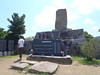
Prototypes of chambered cairn (2c AD) on a hill by the seashore. 3 cairns with stone coffins and menhir.
You may be viewing yesterday's version of this page. To see the most up to date information please register for a free account.
Do not use the above information on other web sites or publications without permission of the contributor.
Nearby Images from Flickr
The above images may not be of the site on this page, but were taken nearby. They are loaded from Flickr so please click on them for image credits.
Click here to see more info for this site
Nearby sites
Click here to view sites on an interactive map of the areaKey: Red: member's photo, Blue: 3rd party photo, Yellow: other image, Green: no photo - please go there and take one, Grey: site destroyed
Download sites to:
KML (Google Earth)
GPX (GPS waypoints)
CSV (Garmin/Navman)
CSV (Excel)
To unlock full downloads you need to sign up as a Contributory Member. Otherwise downloads are limited to 50 sites.
Turn off the page maps and other distractions
Nearby sites listing. In the following links * = Image available
2.7km ENE 65° Toyo* Chambered Cairn
9.6km SW 229° Sago Shiratake* Chambered Cairn
9.7km WSW 244° Tenjin Takuzutama Jinja shrine* Pyramid / Mastaba
10.3km SSE 153° Tōnosaki* Cairn
29.3km SSW 192° Wajima Kofun* Chambered Cairn
29.6km SSW 194° Kuwabaru Kofun* Cist
32.9km S 189° Toyotama-no Igaki* Hillfort
38.1km S 191° Tsukatōzaki* Chambered Cairn
39.3km SSW 196° Kaifuzaki Kofun* Chambered Cairn
39.8km SSW 193° Shimayama Akasaki* Chambered Cairn
44.1km SSW 199° Kanata-no-ki* Hillfort
46.9km SSW 192° Neso Kofungun* Chambered Cairn
46.9km SSW 193° Deizuka Kofun* Chambered Cairn
53.7km SSW 203° Yatateyama kofungun* Passage Grave
57.1km NW 318° 동삼동 Burial Chamber or Dolmen
63.1km NW 324° 동래 Burial Chamber or Dolmen
63.8km SSW 198° Hatchōkaku* Pyramid / Mastaba
70.3km NNW 330° 농소리 Burial Chamber or Dolmen
73.2km NW 320° 금곡동 Burial Chamber or Dolmen
76.3km NNW 338° CheolMa seondol* Standing Stone (Menhir)
79.4km NW 321° Gimae Hoehyeon-ni paechong* Ancient Village or Settlement
80.7km NW 321° Gujibong* Burial Chamber or Dolmen
81.3km NW 320° Nae-dong chiseokmyo* Burial Chamber or Dolmen
90.8km NNW 345° Eunhyeon-ni cheokseokchong* Chambered Cairn
94.5km NW 323° 김해 Burial Chamber or Dolmen
View more nearby sites and additional images


 We would like to know more about this location. Please feel free to add a brief description and any relevant information in your own language.
 Wir möchten mehr über diese Stätte erfahren. Bitte zögern Sie nicht, eine kurze Beschreibung und relevante Informationen in Deutsch hinzuzufügen.
 Nous aimerions en savoir encore un peu sur les lieux. S'il vous plaît n'hesitez pas à ajouter une courte description et tous les renseignements pertinents dans votre propre langue.
 Quisieramos informarnos un poco más de las lugares. No dude en añadir una breve descripción y otros datos relevantes en su propio idioma.