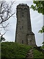
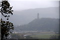
<< Our Photo Pages >> Abbey Craig Vitrified Fort - Hillfort in Scotland in Stirling
Submitted by Andy B on Monday, 05 April 2010 Page Views: 8015
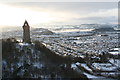
Iron Age and Later PrehistorySite Name: Abbey Craig Vitrified Fort Alternative Name: Wallace MonumentCountry: Scotland County: Stirling Type: Hillfort
Nearest Town: Stirling Nearest Village: Causewayhead
Map Ref: NS80949565
Latitude: 56.138654N Longitude: 3.917527W
Condition:
| 5 | Perfect |
| 4 | Almost Perfect |
| 3 | Reasonable but with some damage |
| 2 | Ruined but still recognisable as an ancient site |
| 1 | Pretty much destroyed, possibly visible as crop marks |
| 0 | No data. |
| -1 | Completely destroyed |
| 5 | Superb |
| 4 | Good |
| 3 | Ordinary |
| 2 | Not Good |
| 1 | Awful |
| 0 | No data. |
| 5 | Can be driven to, probably with disabled access |
| 4 | Short walk on a footpath |
| 3 | Requiring a bit more of a walk |
| 2 | A long walk |
| 1 | In the middle of nowhere, a nightmare to find |
| 0 | No data. |
| 5 | co-ordinates taken by GPS or official recorded co-ordinates |
| 4 | co-ordinates scaled from a detailed map |
| 3 | co-ordinates scaled from a bad map |
| 2 | co-ordinates of the nearest village |
| 1 | co-ordinates of the nearest town |
| 0 | no data |
Internal Links:
External Links:
")
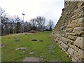
Near the north end of Abbey Craig there is a fort, which has been damaged by the construction within it of the Wallace Monument. All that remain is a substantial turf-covered bank, crescentic on plan and 260ft in length, the ends of which lie close to the brink of the precipice that forms the W face of the hill.
The bank stands to a maximum height of 5ft above the level of the interior and presumably represents a ruined timber-laced wall since numerous pieces of vitrified stones have been found on the slopes immediately below it. The entrance presumably lay between one end of the bank and the lip of the precipice, but both of the areas concerned have been disturbed by the construction of modern approaches.
Source: Canmore ID 47113 which contains extensive notes, an archaeological evaluation from September 2011 and the report of a field visit from September 2012.
You may be viewing yesterday's version of this page. To see the most up to date information please register for a free account.
")
Do not use the above information on other web sites or publications without permission of the contributor.
Andy B has found this location on Google Street View:
Nearby Images from Geograph Britain and Ireland:
©2023(licence)
©2017(licence)
©2012(licence)
©2018(licence)
©2011(licence)
The above images may not be of the site on this page, they are loaded from Geograph.
Please Submit an Image of this site or go out and take one for us!
Click here to see more info for this site
Nearby sites
Key: Red: member's photo, Blue: 3rd party photo, Yellow: other image, Green: no photo - please go there and take one, Grey: site destroyed
Download sites to:
KML (Google Earth)
GPX (GPS waypoints)
CSV (Garmin/Navman)
CSV (Excel)
To unlock full downloads you need to sign up as a Contributory Member. Otherwise downloads are limited to 50 sites.
Turn off the page maps and other distractions
Nearby sites listing. In the following links * = Image available
463m WNW 287° Bel Stane (Causewayhead) Standing Stone (Menhir) (NS805958)
965m NNE 27° Airthrey Stone* Standing Stone (Menhir) (NS81409650)
1.1km NNE 25° The Victoria Stone* Marker Stone (NS8141296608)
1.3km NNW 343° Pathfoot Stone* Standing Stone (Menhir) (NS8060496871)
1.4km NNE 23° Logie Old Kirk (Stirling)* Early Christian Sculptured Stone (NS81549696)
1.8km NNW 328° Lentran (Bridge of Allan) Cist (NS80039720)
2.0km SW 234° Our Lady's Well (Stirling) Holy Well or Sacred Spring (NS79329454)
2.4km N 8° Fairy Well (Logie)* Holy Well or Sacred Spring (NS81359804)
2.7km SW 227° Butt Well* Holy Well or Sacred Spring (NS78949389)
2.9km NNW 331° Fairy Knowe (Bridge of Allan)* Cairn (NS79619818)
2.9km SSW 204° St Ninian's Well (Stirling)* Holy Well or Sacred Spring (NS7969093012)
3.5km SSW 198° Wester Livilands* Broch or Nuraghe (NS7979692369)
3.5km SSW 203° Randolphfield Stones* Standing Stones (NS79449244)
3.5km N 351° Cuparlaw Wood (Bridge of Allan) Cairn (NS80469916)
3.6km N 3° Pendreich 3 (Bridge of Allan) Cairn (NS81259922)
3.6km N 3° Pendreich 1 (Bridge of Allan) Cairn (NS8124499236)
3.7km N 1° Split Stone (Bridge of Allan) Standing Stone (Menhir) (NS8111699311)
3.7km SW 222° King's Park Cup and Rings* Rock Art (NS7837892998)
3.7km N 3° Pendreich 2 (Bridge of Allan) Cairn (NS81239938)
3.9km SW 223° Douglas Terrace (Cambusbarron) Cairn (NS782929)
3.9km SW 218° Coneypark Nursery (Cambusbarron)* Cairn (NS78409263)
4.0km SW 228° St Thomas's Well (Cambusbarron)* Holy Well or Sacred Spring (NS7788493056)
4.1km N 5° The Great Stane O' Pendreigh* Standing Stone (Menhir) (NS8138299686)
4.2km SW 222° Birkill House Cairn (NS780926)
4.4km SW 223° Chapel Well (Cambusbarron)* Holy Well or Sacred Spring (NS77819251)
View more nearby sites and additional images


 We would like to know more about this location. Please feel free to add a brief description and any relevant information in your own language.
 Wir möchten mehr über diese Stätte erfahren. Bitte zögern Sie nicht, eine kurze Beschreibung und relevante Informationen in Deutsch hinzuzufügen.
 Nous aimerions en savoir encore un peu sur les lieux. S'il vous plaît n'hesitez pas à ajouter une courte description et tous les renseignements pertinents dans votre propre langue.
 Quisieramos informarnos un poco más de las lugares. No dude en añadir una breve descripción y otros datos relevantes en su propio idioma.