

<< Text Pages >> Radcliffe Infirmary prehistoric monumental landscape - Round Barrow(s) in England in Oxfordshire
Submitted by Andy B on Monday, 09 November 2009 Page Views: 5941
Neolithic and Bronze AgeSite Name: Radcliffe Infirmary prehistoric monumental landscapeCountry: England County: Oxfordshire Type: Round Barrow(s)
Nearest Town: Oxford
Map Ref: SP5103607101
Latitude: 51.760278N Longitude: 1.261944W
Condition:
| 5 | Perfect |
| 4 | Almost Perfect |
| 3 | Reasonable but with some damage |
| 2 | Ruined but still recognisable as an ancient site |
| 1 | Pretty much destroyed, possibly visible as crop marks |
| 0 | No data. |
| -1 | Completely destroyed |
| 5 | Superb |
| 4 | Good |
| 3 | Ordinary |
| 2 | Not Good |
| 1 | Awful |
| 0 | No data. |
| 5 | Can be driven to, probably with disabled access |
| 4 | Short walk on a footpath |
| 3 | Requiring a bit more of a walk |
| 2 | A long walk |
| 1 | In the middle of nowhere, a nightmare to find |
| 0 | No data. |
| 5 | co-ordinates taken by GPS or official recorded co-ordinates |
| 4 | co-ordinates scaled from a detailed map |
| 3 | co-ordinates scaled from a bad map |
| 2 | co-ordinates of the nearest village |
| 1 | co-ordinates of the nearest town |
| 0 | no data |
Internal Links:
External Links:
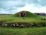
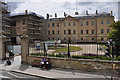
Ring Ditches and other features in Oxfordshire. Archaeologists excavating the former Radcliffe Infirmary site in Oxford have uncovered evidence of a prehistoric monumental landscape stretching across the gravel terrace between the Thames and Cherwell rivers.
The work was carried out over the summer in preparation for Oxford University's proposed Radcliffe Observatory Quarter - plans for which were revealed earlier this month.
In addition to these findings, the work has also uncovered evidence of a 6th century Saxon settlement, including a sunken featured craft hut known as a Grübenhauser and a pit containing unfired clay loom weights.
A team from Museum of London Archaeology (MOLA) has been excavating parts of the 3.7 hectare site. The excavation has revealed evidence of three large prehistoric 'ring ditches' along with some evidence of possible associated cremation burials and an enigmatic rectangular enclosure, finds from which are currently being subjected to radio carbon dating.
Mike Wigg, Head of Capital Projects at Oxford University, said: 'The University was delighted to provide the opportunity for an investigation of Oxford heritage to be carried out in advance of any development work.'
The River Thames was an important focus for monument building in the Neolithic and Bronze Age periods when monuments used for burial, ritual and social purposes were constructed along the gravel terraces of the river.
A spokesperson from MOLA explained: 'Ring ditches are, as the name suggests, circular ditches, which are often the remains of ploughed out barrows, that may be associated with burials of high status individuals in the later Neolithic or Bronze Age, about 4000 years ago.'
The archaeologists had suspected the presence of prehistoric remains because a 12th century documentary source records 'the croft of the three barrows' in this area. Parch marks of a possible sequence of ring ditches in University Parks had indicated that similar remains might be present on the Radcliffe site.
The Saxon activity around the much earlier barrow cemetery is not uncommon and is recorded at other similar sites along the Thames. However, this is the first evidence for such a relationship in Oxford. The archaeologists are now working on the post-excavation phase of the project.
Read more, with a photo of the excavation at Science Daily
You may be viewing yesterday's version of this page. To see the most up to date information please register for a free account.
Do not use the above information on other web sites or publications without permission of the contributor.
Nearby Images from Geograph Britain and Ireland:
©2010(licence)
©2010(licence)
©2014(licence)
©2014(licence)

©2023(licence)
The above images may not be of the site on this page, they are loaded from Geograph.
Please Submit an Image of this site or go out and take one for us!
Click here to see more info for this site
Nearby sites
Key: Red: member's photo, Blue: 3rd party photo, Yellow: other image, Green: no photo - please go there and take one, Grey: site destroyed
Download sites to:
KML (Google Earth)
GPX (GPS waypoints)
CSV (Garmin/Navman)
CSV (Excel)
To unlock full downloads you need to sign up as a Contributory Member. Otherwise downloads are limited to 50 sites.
Turn off the page maps and other distractions
Nearby sites listing. In the following links * = Image available
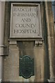
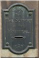
223m SE 133° Kendrew Quadrangle* Henge (SP51200695)
496m ESE 108° Pitt Rivers Museum* Museum (SP51510695)
594m WNW 291° Walton Well* Holy Well or Sacred Spring (SP5047907312)
604m S 175° Ashmolean Museum of Art and Archaeology* Museum (SP511065)
1.0km SSE 166° Museum of Oxford* Museum (SP513061)
2.6km WNW 291° St Margaret's Well (Binsey)* Holy Well or Sacred Spring (SP486080)
2.9km SE 124° St Bartholomew's Well Holy Well or Sacred Spring (SP5349805476)
6.3km NW 321° Yarnton* Ancient Village or Settlement (SP4712)
7.4km WSW 249° Physic Well (Cumnor)* Holy Well or Sacred Spring (SP4412604375)
8.5km W 277° Deadman's Burial 2 Henge (SP42610807)
8.6km W 281° Eynsham Timber Circle Timber Circle (SP425086)
8.7km W 276° Deadman's Burial 1 Misc. Earthwork (SP42350795)
8.8km S 176° Barrow Hills Radley I Timber Circle (SU518983)
9.3km SW 233° Badger's Well* Holy Well or Sacred Spring (SP4360201485)
9.5km W 262° Stanton Harcourt Church Cross* Ancient Cross (SP4164305666)
10.2km WSW 257° Devils Quoits* Stone Circle (SP41120476)
10.5km ESE 117° Cuddesdon Stones Upper Standing Stone (Menhir) (SP6042102411)
10.7km S 189° Abingdon Cursus Cursus (SU494965)
10.7km W 261° Gravelly Guy Timber Circle (SP404054)
10.9km ESE 118° Cuddesdon Stones Lower Standing Stone (Menhir) (SP6070002018)
11.9km NW 322° Fair Rosamund's Well* Holy Well or Sacred Spring (SP43651646)
11.9km SE 133° Stadhampton Cursus Cursus (SU59909910)
12.0km WSW 242° Northmoor Linear Ditches* Barrow Cemetery (SP40390142)
12.1km SE 134° Stadhampton Cursus Cursus (SU59799875)
12.2km S 189° Drayton North Cursus Cursus (SU492950)
View more nearby sites and additional images


 We would like to know more about this location. Please feel free to add a brief description and any relevant information in your own language.
 Wir möchten mehr über diese Stätte erfahren. Bitte zögern Sie nicht, eine kurze Beschreibung und relevante Informationen in Deutsch hinzuzufügen.
 Nous aimerions en savoir encore un peu sur les lieux. S'il vous plaît n'hesitez pas à ajouter une courte description et tous les renseignements pertinents dans votre propre langue.
 Quisieramos informarnos un poco más de las lugares. No dude en añadir una breve descripción y otros datos relevantes en su propio idioma.