 with our Megalithic Portal iPhone app")

<< Text Pages >> Grodzisko Kiełpin 1 - Hillfort in Poland in Wielkopolskie
Submitted by SolarMegalith on Tuesday, 18 August 2009 Page Views: 3322
Iron Age and Later PrehistorySite Name: Grodzisko Kiełpin 1 Alternative Name: Góra ZamkowaCountry: Poland Voivodeship: Wielkopolskie Type: Hillfort
Nearest Town: Piła Nearest Village: Kiełpin
Latitude: 53.517500N Longitude: 17.052222E
Condition:
| 5 | Perfect |
| 4 | Almost Perfect |
| 3 | Reasonable but with some damage |
| 2 | Ruined but still recognisable as an ancient site |
| 1 | Pretty much destroyed, possibly visible as crop marks |
| 0 | No data. |
| -1 | Completely destroyed |
| 5 | Superb |
| 4 | Good |
| 3 | Ordinary |
| 2 | Not Good |
| 1 | Awful |
| 0 | No data. |
| 5 | Can be driven to, probably with disabled access |
| 4 | Short walk on a footpath |
| 3 | Requiring a bit more of a walk |
| 2 | A long walk |
| 1 | In the middle of nowhere, a nightmare to find |
| 0 | No data. |
| 5 | co-ordinates taken by GPS or official recorded co-ordinates |
| 4 | co-ordinates scaled from a detailed map |
| 3 | co-ordinates scaled from a bad map |
| 2 | co-ordinates of the nearest village |
| 1 | co-ordinates of the nearest town |
| 0 | no data |
Internal Links:
External Links:
Hillfort in Wielkopolskie
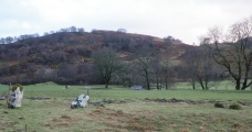
On the top of the hill called Góra Zamkowa, near the river Dobrzynka, there's a large hillfort with a well-preserved ditch and rampart. It's dated for 8th century AD.
You may be viewing yesterday's version of this page. To see the most up to date information please register for a free account.
Do not use the above information on other web sites or publications without permission of the contributor.
Click here to see more info for this site
Nearby sites
Click here to view sites on an interactive map of the areaKey: Red: member's photo, Blue: 3rd party photo, Yellow: other image, Green: no photo - please go there and take one, Grey: site destroyed
Download sites to:
KML (Google Earth)
GPX (GPS waypoints)
CSV (Garmin/Navman)
CSV (Excel)
To unlock full downloads you need to sign up as a Contributory Member. Otherwise downloads are limited to 50 sites.
Turn off the page maps and other distractions
Nearby sites listing. In the following links * = Image available
502m ENE 72° Grodzisko Kiełpin 2 Hillfort
26.4km WNW 294° Grodzisko Wilcze Laski Hillfort
38.6km S 176° Grodzisko Wysoczka Hillfort
46.9km S 184° Grodzisko Miasteczko Krajeńskie Hillfort
53.4km NNW 331° Grodzisko Porost Promontory Fort / Cliff Castle
54.8km SSE 161° Grodzisko Smogulec Hillfort
60.4km NNW 337° Grodzisko Stare Borne Hillfort
61.2km NNW 338° Kurhany Żydowo* Barrow Cemetery
62.8km NE 42° Kurhany Leśno* Barrow Cemetery
69.2km NE 39° Kurhany Główczewice Barrow Cemetery
69.5km NW 311° Tychowo - Głaz Trygława* Natural Stone / Erratic / Other Natural Feature
70.9km NNW 339° Polanów Sacred Mountain* Holy Well or Sacred Spring
71.2km NNW 326° Grzybnica* Stone Circle
74.0km W 265° Grodzisko Lubieszewo Hillfort
75.0km NE 55° Odry* Stone Circle
79.2km NNW 343° Grodzisko Krąg* Hillfort
79.4km ENE 67° Starzyska Stone Circles Stone Circle
79.4km ENE 63° Złe Mięso Stone Circles Stone Circle
80.9km WNW 290° Grodzisko Cieszeniewo Hillfort
81.8km W 276° Grodzisko Żółte Promontory Fort / Cliff Castle
82.2km S 189° Grodzisko Ninino Hillfort
84.3km NNE 27° Kurhan Gołczewo* Round Barrow(s)
84.4km S 183° Grodzisko Żydowska Górka - Rogoźno* Hillfort
84.5km NNW 340° Borkowo Barrow Cemetery Round Barrow(s)
84.5km NNW 340° Borkowo Dolmen II.* Chambered Tomb
View more nearby sites and additional images


 We would like to know more about this location. Please feel free to add a brief description and any relevant information in your own language.
 Wir möchten mehr über diese Stätte erfahren. Bitte zögern Sie nicht, eine kurze Beschreibung und relevante Informationen in Deutsch hinzuzufügen.
 Nous aimerions en savoir encore un peu sur les lieux. S'il vous plaît n'hesitez pas à ajouter une courte description et tous les renseignements pertinents dans votre propre langue.
 Quisieramos informarnos un poco más de las lugares. No dude en añadir una breve descripción y otros datos relevantes en su propio idioma.