


<< Our Photo Pages >> Loughcrew Cairn W - Passage Grave in Ireland (Republic of) in Co. Meath
Submitted by jeffrep on Sunday, 09 August 2009 Page Views: 3505
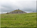
Neolithic and Bronze AgeSite Name: Loughcrew Cairn WCountry: Ireland (Republic of) County: Co. Meath Type: Passage Grave
Nearest Town: Oldcastle
Latitude: 53.744944N Longitude: 7.110745W
Condition:
| 5 | Perfect |
| 4 | Almost Perfect |
| 3 | Reasonable but with some damage |
| 2 | Ruined but still recognisable as an ancient site |
| 1 | Pretty much destroyed, possibly visible as crop marks |
| 0 | No data. |
| -1 | Completely destroyed |
| 5 | Superb |
| 4 | Good |
| 3 | Ordinary |
| 2 | Not Good |
| 1 | Awful |
| 0 | No data. |
| 5 | Can be driven to, probably with disabled access |
| 4 | Short walk on a footpath |
| 3 | Requiring a bit more of a walk |
| 2 | A long walk |
| 1 | In the middle of nowhere, a nightmare to find |
| 0 | No data. |
| 5 | co-ordinates taken by GPS or official recorded co-ordinates |
| 4 | co-ordinates scaled from a detailed map |
| 3 | co-ordinates scaled from a bad map |
| 2 | co-ordinates of the nearest village |
| 1 | co-ordinates of the nearest town |
| 0 | no data |
Internal Links:
External Links:
I have visited· I would like to visit
SteveC would like to visit
jeffrep visited on 18th Apr 2009 - their rating: Cond: 2 Amb: 4 Access: 2
coin visited - their rating: Cond: 3 Amb: 4 Access: 4
Average ratings for this site from all visit loggers: Condition: 2.5 Ambience: 4 Access: 3
")
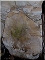
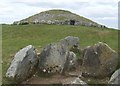
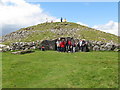
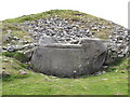
Cairn W is located in the Carnbane East complex of tombs where Cairn T is the centerpiece.
You may be viewing yesterday's version of this page. To see the most up to date information please register for a free account.
")
Do not use the above information on other web sites or publications without permission of the contributor.
Nearby Images from Geograph Britain and Ireland:
©2010(licence)
©2010(licence)
©2011(licence)
©2011(licence)
©2011(licence)
The above images may not be of the site on this page, they are loaded from Geograph.
Please Submit an Image of this site or go out and take one for us!
Click here to see more info for this site
Nearby sites
Click here to view sites on an interactive map of the areaKey: Red: member's photo, Blue: 3rd party photo, Yellow: other image, Green: no photo - please go there and take one, Grey: site destroyed
Download sites to:
KML (Google Earth)
GPX (GPS waypoints)
CSV (Garmin/Navman)
CSV (Excel)
To unlock full downloads you need to sign up as a Contributory Member. Otherwise downloads are limited to 50 sites.
Turn off the page maps and other distractions
Nearby sites listing. In the following links * = Image available
79m SW 229° Loughcrew Cairn V* Passage Grave
90m W 270° Loughcrew Cairn U* Passage Grave (N5862977605)
119m WSW 257° Loughcrew Cairn T* Chambered Cairn (N5860477578)
146m W 262° Loughcrew Cairn S* Passage Grave (N5857577584)
170m WSW 241° Loughcrew Cairn R2 Passage Grave
178m WSW 248° Loughcrew Cairn R1* Chambered Tomb (SA6300139696)
413m NE 44° Ballinvally ME009-084 Rock Art (N5900377909)
419m SW 236° Loughcrew Cairns P2 & Q* Chambered Tomb (SA6280539543)
470m SW 233° Loughcrew Cairn P1* Chambered Tomb (SA6277639492)
581m SW 223° Loughcrew Cairn N-Stones* Standing Stones (SA6274039359)
600m SW 225° Loughcrew Cairn N* Chambered Tomb (SA6271339360)
749m WSW 247° Loughcrew Cairn O* Burial Chamber or Dolmen (SA6246139503)
810m WSW 248° Loughcrew Ring Barrow* Round Barrow(s) (SA6239639502)
831m ENE 70° Cairn X1* Passage Grave (N595779)
1.1km NW 326° Ballinvalley* Stone Circle (N581785)
1.5km W 263° Loughcrew Cairn L* Chambered Cairn (N5719877410)
1.6km W 260° Carbane West Chambered Cairn (N571773)
4.8km ENE 68° Kingsmountain Decorated Stone* Rock Art
7.4km NW 314° Farranaglogh Standing Stones
10.6km NNE 24° Fort Williams Stone Fort or Dun
19.8km SE 132° Tlachtga* Hillfort
23.6km W 280° Cartronbore Stone Circle
27.0km SW 216° St Brigid's Well, Cullion* Holy Well or Sacred Spring (N42925570)
28.8km ESE 110° Donaghmore Stone Circle (N860680)
31.9km ENE 72° Garret's Stone Standing Stone (Menhir) (N891877)
View more nearby sites and additional images


 We would like to know more about this location. Please feel free to add a brief description and any relevant information in your own language.
 Wir möchten mehr über diese Stätte erfahren. Bitte zögern Sie nicht, eine kurze Beschreibung und relevante Informationen in Deutsch hinzuzufügen.
 Nous aimerions en savoir encore un peu sur les lieux. S'il vous plaît n'hesitez pas à ajouter une courte description et tous les renseignements pertinents dans votre propre langue.
 Quisieramos informarnos un poco más de las lugares. No dude en añadir una breve descripción y otros datos relevantes en su propio idioma.