

<< Our Photo Pages >> Disgwylfa Fach Stone Row - Stone Row / Alignment in Wales in Ceredigion
Submitted by coldrum on Sunday, 12 July 2009 Page Views: 3873
Neolithic and Bronze AgeSite Name: Disgwylfa Fach Stone RowCountry: Wales County: Ceredigion Type: Stone Row / Alignment
Map Ref: SN73098360
Latitude: 52.435596N Longitude: 3.868268W
Condition:
| 5 | Perfect |
| 4 | Almost Perfect |
| 3 | Reasonable but with some damage |
| 2 | Ruined but still recognisable as an ancient site |
| 1 | Pretty much destroyed, possibly visible as crop marks |
| 0 | No data. |
| -1 | Completely destroyed |
| 5 | Superb |
| 4 | Good |
| 3 | Ordinary |
| 2 | Not Good |
| 1 | Awful |
| 0 | No data. |
| 5 | Can be driven to, probably with disabled access |
| 4 | Short walk on a footpath |
| 3 | Requiring a bit more of a walk |
| 2 | A long walk |
| 1 | In the middle of nowhere, a nightmare to find |
| 0 | No data. |
| 5 | co-ordinates taken by GPS or official recorded co-ordinates |
| 4 | co-ordinates scaled from a detailed map |
| 3 | co-ordinates scaled from a bad map |
| 2 | co-ordinates of the nearest village |
| 1 | co-ordinates of the nearest town |
| 0 | no data |
Internal Links:
External Links:
I have visited· I would like to visit
SandyG visited on 21st Mar 2016 - their rating: Cond: 2 Amb: 4 Access: 4 Limited road verge car parking is available at SN 72829 83600. From here walk up the farm track to SN 72866 83754. Head east following the fence and cross the small stream. The ground is very uneven so take care. Once across the stream head south east towards the row.
")
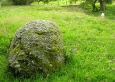
Series of 7 stones, possibly standing, each in closely spread row (NE-SW).
This stone row is recorded as Coflein NPRN 282230.
Update September 2019: This stone row is featured on the Stone Rows of Great Britain - see their entry for Disgwylfa Fach, which includes a description, photographs of the row and the individual stones, a plan of the row and its associated features (from a survey in March 2016), plus access information. The survey concludes that the row is 14.6m long, with 8 small and medium stones, the larges stone being a quartz boulder at its northern end.
The SRoGB adds: " …. the possibility of it being the much truncated remains of a field boundary cannot be entirely discounted". They also add a note of caution for visitors: "The ground is very uneven so take care".
You may be viewing yesterday's version of this page. To see the most up to date information please register for a free account.
")
")
")
")
")
")
")
Do not use the above information on other web sites or publications without permission of the contributor.
Click here to see more info for this site
Nearby sites
Key: Red: member's photo, Blue: 3rd party photo, Yellow: other image, Green: no photo - please go there and take one, Grey: site destroyed
Download sites to:
KML (Google Earth)
GPX (GPS waypoints)
CSV (Garmin/Navman)
CSV (Excel)
To unlock full downloads you need to sign up as a Contributory Member. Otherwise downloads are limited to 50 sites.
![]()
Turn off the page maps and other distractions
Nearby sites listing. In the following links * = Image available
3m NNW 337° Glandwr Standing Stone* Standing Stone (Menhir) (SN7308983603)
49m NNE 19° Disgwylfa Fach Stone I* Standing Stones (SN7310783646)
53m NNE 22° Disgwylfa Fach Stone 3* Standing Stone (Menhir) (SN7311183649)
56m NW 313° Disgwylfa Fach Menhir 4* Standing Stone (Menhir) (SN7305083639)
58m W 269° Disgwylfa Fach Cairn* Cairn (SN7303283600)
74m NNE 20° Disgwylfa Fach Stone 2* Standing Stone (Menhir) (SN7311783669)
174m NNW 342° Disgwylfa Fach Menhir 5* Standing Stone (Menhir) (SN7303983767)
258m NNE 15° Syfydrin Menhir* Standing Stone (Menhir) (SN7316583847)
303m W 269° Esgair Gorlan Chambered Tomb* Chambered Tomb (SN7278683603)
303m SSE 161° Nant Geifaes Cairn (SN73188331)
361m NNW 344° Gwenffrwd-Uchaf Cairns Cairn (SN73008395)
423m W 268° Esgair Gorlan Menhir Standing Stone (Menhir) (SN7266683594)
519m W 272° Castell Coch Stone* Standing Stone (Menhir) (SN72578363)
836m WSW 251° Buwch a'r Llo* Standing Stones (SN72298335)
892m S 169° Gorlan Cairn Cairn (SN73248272)
894m S 173° Esgair Gorlan Cairn I Cairn (SN73188271)
955m WSW 252° Maen Tarw* Standing Stone (Menhir) (SN7217183332)
1.0km SW 226° Esgair Gorlan Stone Standing Stone (Menhir) (SN72348292)
1.0km SSW 192° Esgair Gorlan Cairn II Cairn (SN72858261)
1.3km ESE 102° Dinas Hillfort (Ceredigion)* Hillfort (SN7433083300)
1.3km NNE 28° Disgwylfa Fawr Round Barrow* Round Barrow(s) (SN73738474)
2.1km E 94° Garn Lwyd Standing Stone* Standing Stone (Menhir) (SN752834)
2.3km E 80° Hirnant* Stone Circle (SN7532683939)
2.3km WSW 245° Carn Dolgau Cairn (SN70978266)
2.7km ENE 65° Lle'r Neuaddau* Stone Circle (SN75548465)
View more nearby sites and additional images


 We would like to know more about this location. Please feel free to add a brief description and any relevant information in your own language.
 Wir möchten mehr über diese Stätte erfahren. Bitte zögern Sie nicht, eine kurze Beschreibung und relevante Informationen in Deutsch hinzuzufügen.
 Nous aimerions en savoir encore un peu sur les lieux. S'il vous plaît n'hesitez pas à ajouter une courte description et tous les renseignements pertinents dans votre propre langue.
 Quisieramos informarnos un poco más de las lugares. No dude en añadir una breve descripción y otros datos relevantes en su propio idioma.