

<< Our Photo Pages >> Tollis Hill - Hillfort in Scotland in Scottish Borders
Submitted by cosmic on Monday, 02 June 2008 Page Views: 7591
Iron Age and Later PrehistorySite Name: Tollis HillCountry: Scotland County: Scottish Borders Type: Hillfort
Map Ref: NT51605804
Latitude: 55.813186N Longitude: 2.773876W
Condition:
| 5 | Perfect |
| 4 | Almost Perfect |
| 3 | Reasonable but with some damage |
| 2 | Ruined but still recognisable as an ancient site |
| 1 | Pretty much destroyed, possibly visible as crop marks |
| 0 | No data. |
| -1 | Completely destroyed |
| 5 | Superb |
| 4 | Good |
| 3 | Ordinary |
| 2 | Not Good |
| 1 | Awful |
| 0 | No data. |
| 5 | Can be driven to, probably with disabled access |
| 4 | Short walk on a footpath |
| 3 | Requiring a bit more of a walk |
| 2 | A long walk |
| 1 | In the middle of nowhere, a nightmare to find |
| 0 | No data. |
| 5 | co-ordinates taken by GPS or official recorded co-ordinates |
| 4 | co-ordinates scaled from a detailed map |
| 3 | co-ordinates scaled from a bad map |
| 2 | co-ordinates of the nearest village |
| 1 | co-ordinates of the nearest town |
| 0 | no data |
Internal Links:
External Links:
")
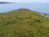
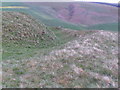
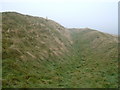
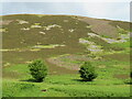
Circular hill fort about three hundred feet in diameter.
More information can be found on Canmore ID 55966 which includes some aerial photographs and a detailed description of the fort which lies within a single rampart and ditch. It "occup(ies) a strong defensive position, (the rampart and ditch) are in a good state of preservation. Within the interior is one sheepfold, 19.0m in diameter and four hollowed-out areas up to 1.0m deep which ... may be the result of quarrying."
You may be viewing yesterday's version of this page. To see the most up to date information please register for a free account.
")
")
")
Do not use the above information on other web sites or publications without permission of the contributor.
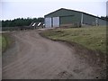
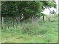
Nearby Images from Geograph Britain and Ireland:
©2008(licence)
©2008(licence)
©2022(licence)
©2006(licence)
©2022(licence)
The above images may not be of the site on this page, they are loaded from Geograph.
Please Submit an Image of this site or go out and take one for us!
Click here to see more info for this site
Nearby sites
Key: Red: member's photo, Blue: 3rd party photo, Yellow: other image, Green: no photo - please go there and take one, Grey: site destroyed
Download sites to:
KML (Google Earth)
GPX (GPS waypoints)
CSV (Garmin/Navman)
CSV (Excel)
To unlock full downloads you need to sign up as a Contributory Member. Otherwise downloads are limited to 50 sites.
Turn off the page maps and other distractions
Nearby sites listing. In the following links * = Image available
307m ESE 103° Tollishill* Standing Stone (Menhir) (NT51905797)
4.5km S 170° Addinston Hill fort* Hillfort (NT523536)
6.1km SW 228° Kirktonhill Stone Circle (NT470540)
6.2km N 356° Kidlaw Hillfort Hillfort (NT512642)
6.3km NNW 328° Leaston House (Humbie) Rock Art (NT483634)
7.1km SE 143° Borrowston Rigg* Stone Circle (NT5576052315)
7.1km SE 143° Borrowstone Rig* Stone Circle (NT55765231)
7.1km SE 144° Borrowstone Rig Round Cairn (NT55775223)
7.5km SSE 155° Dabshead Hill* Standing Stone (Menhir) (NT54715124)
10.7km E 84° Mutiny Stones* Cairn (NT62255902)
10.9km SE 142° Blythe Fort Hillfort (NT58244941)
11.0km SSE 150° Thirlestane Hill Hillfort (NT57054845)
11.3km ESE 107° Twin Law Cairns* Cairn (NT624547)
11.6km SE 135° Bruntaburn Mill* Standing Stone (Menhir) (NT59814979)
11.7km ESE 109° Kingside Hill (Cranshaws) Stone Circle (NT62635403)
11.9km SE 144° Cambridge Standing Stone* Standing Stone (Menhir) (NT58434826)
11.9km SSW 202° Cathpair Standing Stone (Menhir) (NT47004700)
12.0km ENE 56° Mayshiel Stone Circle (NT617646)
12.2km WNW 288° Crichton Souterrain* Souterrain (Fogou, Earth House) (NT40016191)
12.5km NE 54° Crow Stones (Cranshaws)* Stone Circle (NT61836519)
13.0km ENE 57° Kingside Hill Stone Circle (NT62636503)
13.1km ENE 56° Stone Standing Stone Standing Stone (Menhir) (NT62586518)
13.1km ENE 61° Penshiel Hill Stone Circle (NT632642)
13.1km ENE 59° Mayshiel Stone Circle* Stone Circle (NT62986465)
13.2km NE 55° Nine Stones Rig* Stone Circle (NT62546549)
View more nearby sites and additional images

")
 We would like to know more about this location. Please feel free to add a brief description and any relevant information in your own language.
 Wir möchten mehr über diese Stätte erfahren. Bitte zögern Sie nicht, eine kurze Beschreibung und relevante Informationen in Deutsch hinzuzufügen.
 Nous aimerions en savoir encore un peu sur les lieux. S'il vous plaît n'hesitez pas à ajouter une courte description et tous les renseignements pertinents dans votre propre langue.
 Quisieramos informarnos un poco más de las lugares. No dude en añadir una breve descripción y otros datos relevantes en su propio idioma.