<< Our Photo Pages >> Westerholte Westgruppe Grab 1 - Chambered Tomb in Germany in Lower Saxony, Bremen
Submitted by Martin_L on Tuesday, 22 April 2008 Page Views: 2882
Neolithic and Bronze AgeSite Name: Westerholte Westgruppe Grab 1Country: Germany Land: Lower Saxony, Bremen Type: Chambered Tomb
Nearest Town: Ankum Nearest Village: Westerholte
Latitude: 52.490650N Longitude: 7.867820E
Condition:
| 5 | Perfect |
| 4 | Almost Perfect |
| 3 | Reasonable but with some damage |
| 2 | Ruined but still recognisable as an ancient site |
| 1 | Pretty much destroyed, possibly visible as crop marks |
| 0 | No data. |
| -1 | Completely destroyed |
| 5 | Superb |
| 4 | Good |
| 3 | Ordinary |
| 2 | Not Good |
| 1 | Awful |
| 0 | No data. |
| 5 | Can be driven to, probably with disabled access |
| 4 | Short walk on a footpath |
| 3 | Requiring a bit more of a walk |
| 2 | A long walk |
| 1 | In the middle of nowhere, a nightmare to find |
| 0 | No data. |
| 5 | co-ordinates taken by GPS or official recorded co-ordinates |
| 4 | co-ordinates scaled from a detailed map |
| 3 | co-ordinates scaled from a bad map |
| 2 | co-ordinates of the nearest village |
| 1 | co-ordinates of the nearest town |
| 0 | no data |
Internal Links:
External Links:
I have visited· I would like to visit
Martin_L has visited here

At Westerholte many megalithic tombs, barrows and a bronze age stone cist are still preserved.
Two groups can be distinguished.
The Eastern group (Giersfeld) with a signposted circuit is very well known.
The Western group is located 1km west of the Eastern group and originally consisted of at least 3 megalithic tombs and some round barrows. The megalithic tombs were situated close to the Ankum-Ueffeln road and are completly destroyed except for Tomb 1.
Tomb 1:
This tomb was hidden in dense wood and discovered very late in the 1950s.
It was situated close to a small stream. According to Tempel [2] its structure was completly destroyed by the landowner in 1972 (!!!) immediately before a scheduled scientific examination. The landowner insisted that he did not knew about the existence of the tomb. While clearing and rooting out the trees he also tore out all stones of the tomb. During following excavation the original positions of the orthostats were traced. Therefore the chamber originally had 10 orthostats a clear length of 8,4m and was covered by 5 capstones.
Fragments of 40 pieces of funnel-beaker pottery were also found.
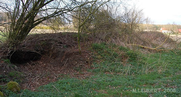
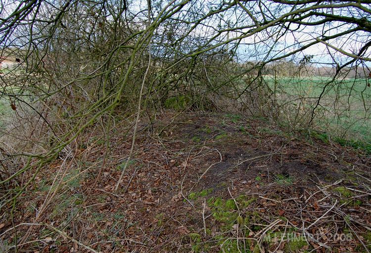
The current situation is uncertain. At the position of the tomb marked in the 1:25000 topographic map an overgrown barrow with some larger stones in it is visible.
References:
[1] W.D. Tempel in: Führer zu vor- und frühgeschichtlichen Denkmälern Band 44, Verlag Philipp von Zabern, Mainz, 1979, p.188-190
[2] W.Schlüter in: Führer zu vor- und frühgeschichtlichen Denkmälern Band 44, Verlag Philipp von Zabern, Mainz, 1979, p. 6-8
You may be viewing yesterday's version of this page. To see the most up to date information please register for a free account.


Do not use the above information on other web sites or publications without permission of the contributor.
Nearby Images from Flickr


The above images may not be of the site on this page, but were taken nearby. They are loaded from Flickr so please click on them for image credits.
Click here to see more info for this site
Nearby sites
Click here to view sites on an interactive map of the areaKey: Red: member's photo, Blue: 3rd party photo, Yellow: other image, Green: no photo - please go there and take one, Grey: site destroyed
Download sites to:
KML (Google Earth)
GPX (GPS waypoints)
CSV (Garmin/Navman)
CSV (Excel)
To unlock full downloads you need to sign up as a Contributory Member. Otherwise downloads are limited to 50 sites.
Turn off the page maps and other distractions
Nearby sites listing. In the following links * = Image available
648m ESE 102° Rickelmann 2 Grosssteingrab* Passage Grave
655m E 100° Rickelmann Hügelgrab 2* Round Barrow(s)
669m ESE 102° Rickelmann Hügelgrab 1* Round Barrow(s)
903m ESE 119° Rickelmann 1 Grosssteingrab* Chambered Tomb
956m E 92° Reinecke Grosssteingrab* Chambered Tomb
1.0km ENE 72° Westerholte Rickelmann III Chambered Tomb
1.0km E 82° Meyer Grosssteingrab* Chambered Tomb
1.1km ENE 62° Westerholte Lange Chambered Tomb
1.1km SE 131° Grumfeld-West Grosssteingrab* Passage Grave
1.2km ESE 122° Giersfeld Grabhügel 2* Round Barrow(s)
1.3km SE 124° Giersfeld menhir* Natural Stone / Erratic / Other Natural Feature
1.4km ESE 123° Giersfeld Grabhügel 3 Round Barrow(s)
1.4km SE 127° Grumfeld-Ost Grosssteingrab* Chambered Tomb
1.4km SE 133° Giersfeld Grabhügel 1* Round Barrow(s)
1.5km SE 130° Giersfeld Steinkiste* Chambered Tomb
3.0km N 5° Tütingen Hügelgräberfeld Barrow Cemetery
3.0km S 176° Ueffeln Steingrab 2* Chambered Tomb
3.2km S 180° Bottumer Kirchweg Huegelgrab* Round Barrow(s)
3.3km N 9° Krähenberg Hügelgrab* Round Barrow(s)
4.1km S 187° Auf der Laue Huegelgrab* Round Barrow(s)
4.2km S 185° Ueffeln Huegelgrab 1 Round Barrow(s)
4.4km S 172° Matthiesings Opferstein* Natural Stone / Erratic / Other Natural Feature
4.5km S 185° Ueffeln Huegelgrab 2* Round Barrow(s)
4.5km S 185° Wiemelsberger Steine* Chambered Tomb
4.5km S 184° Ueffeln Huegelgrab 3* Round Barrow(s)
View more nearby sites and additional images


 We would like to know more about this location. Please feel free to add a brief description and any relevant information in your own language.
 Wir möchten mehr über diese Stätte erfahren. Bitte zögern Sie nicht, eine kurze Beschreibung und relevante Informationen in Deutsch hinzuzufügen.
 Nous aimerions en savoir encore un peu sur les lieux. S'il vous plaît n'hesitez pas à ajouter une courte description et tous les renseignements pertinents dans votre propre langue.
 Quisieramos informarnos un poco más de las lugares. No dude en añadir una breve descripción y otros datos relevantes en su propio idioma.