 with our Megalithic Portal iPhone app")

<< Feature Articles >> Cueva del Milodon - Cave or Rock Shelter in Chile
Submitted by C_Michael_Hogan on Sunday, 13 April 2008 Page Views: 29095
Natural PlacesSite Name: Cueva del MilodonCountry: Chile Type: Cave or Rock Shelter
Nearest Town: Puerto Natales
Latitude: 51.565217S Longitude: 72.618933W
Condition:
| 5 | Perfect |
| 4 | Almost Perfect |
| 3 | Reasonable but with some damage |
| 2 | Ruined but still recognisable as an ancient site |
| 1 | Pretty much destroyed, possibly visible as crop marks |
| 0 | No data. |
| -1 | Completely destroyed |
| 5 | Superb |
| 4 | Good |
| 3 | Ordinary |
| 2 | Not Good |
| 1 | Awful |
| 0 | No data. |
| 5 | Can be driven to, probably with disabled access |
| 4 | Short walk on a footpath |
| 3 | Requiring a bit more of a walk |
| 2 | A long walk |
| 1 | In the middle of nowhere, a nightmare to find |
| 0 | No data. |
| 5 | co-ordinates taken by GPS or official recorded co-ordinates |
| 4 | co-ordinates scaled from a detailed map |
| 3 | co-ordinates scaled from a bad map |
| 2 | co-ordinates of the nearest village |
| 1 | co-ordinates of the nearest town |
| 0 | no data |
Internal Links:
External Links:
I have visited· I would like to visit
DrewParsons C_Michael_Hogan have visited here
")
These Selk'nam hunting tribes enjoyed abundant wildlife and also exploited estuarine resources of the Seno Ultima Esperanza (inlet). The higher water levels in the early Holocene (bringing Holocene water levels nearer the caves) may be a product of geologic uplift of these steppe terraces combined with changes in circulation of the southerly lagoons, which presently manifest narrow connecting necks. Hiking to an overlook above the Cueva del Milodon provides an excellent overview of the steppe terrain with a view of the Seno Ultima Esperanza.
ENVIRONMENT The Milodon cave complex rises somewhat abrubtly above the broad plain to the south, with the caves all situated on the southern flanks of the Cerro Benitez Mountains. The caves are generally formed of limestone conglomerate, and are surrounded by moderately dense Nothofagus forest, with Lenga, Nirre and Magellan's Beech species all represented. A rich understory of scrub plants, wildflowers, mosses and lichens are found on the rock studded soils. Prominent understory scrub includes ‘'Maytenus magellanica'‘, ‘'Escallonia virgata'‘, ‘'Baccharis Patigonica'‘, ‘'Escallonia leucantha'‘, ‘'Berberis buxifolia'‘, ‘'Berberis darwinii'‘, ‘'Gaultheria mucronata'‘, the last three providing edible berries to the prehistoric Selk'nam.
Presently a large variety of avafauna are found at Cueva del Milodon including the raptors Andean condor, Carancho, Vari, Cernicalo and Magellanic horned owl. Other bird species present are the Chilean flicker, Austral blackbird and Thorn-tailed rayadito. Mammals that occur on site include the Andean fox, Puma, Chingue skunk and Geoffroy's wildcat.
Pollen analysis from archaeological recovery indicates the landscape of the early Holocene at this location had fewer trees and could be considered a scrub steppe. (Auer, 1955) Remains within Cueva del Milodon indicate the Early Holocene presence of the extinct horse ‘'Hippidion saldiasi'‘, the extinct ‘'Smilodon populator'‘, ‘'Llama glama'‘ and guanaco. The hunting culture and landscape palette at Cueva del Milodon was likely comparable to the steppes at Pali Aike to the east. (Hogan, 2008)
The Seno Ultima Esperanza, as noted above, was known to extend closer to Cueva del Milodon in the early Holocene. That waterway is connected to the Pacific Ocean through a circuitous route. I measured the water quality nearby to be rather lacking in turbidity, brackish, but with considerable freshwater influence. March water temperature of the sound was 15.4 degrees Celsius and the pH was somewhat alkaline at 9.1. All of these conditions auger well for abundant prehistoric seafood yield. Freshwater would have derived from a more considerable glacial melt runoff from the Patagonian Icefield, which in the early to mid Holocene would have been much closer than today, leading to a much more extensive prehistoric size of Lago Porteno and Lago del Toro to the north..
ARCHAEOLOGICAL RECOVERY Diverse elements of human habitation are found at Cueva del Milodon including fire fractured rock, lithic tools and human remains. In addition, bones and even skin of the extinct Giant Sloth (genus ‘'Mylodon'‘) were recovered within the massive cave itself. Presently these Mylodon remains and some of the other artifacts are exhibited at the Puntas Arenas Museo Regional de Magallanes . The Giant Sloth could stand on its hind legs and towered to three meters in height. It is thought that the Milodon used the cave for shelter, until man arrived to this site and hunted the Giant Sloth to extinction. Skin, bones and teeth of the Giant Sloth have been recovered from within the cave.
Human habitation at Cueva del Milodon is dated as early as 6000 BC. (Heusser, 2003) Lithic recovery from the site includes arrow points, preform tools and scraper tools. In my visit to Cueva del Milodon I found a few core tools and one unifacial chopper in the principal cave itself, likely dating to Neolithic usage.
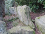
CAVE GEOMETRY The principal cave is extremely large in aperture, with an entrance height of approximately 29 meters and a width of about 121 meters. The cave depth exceeds 200 meters. Substantial active stalactites are observed near the cave entrance dripline. After entering the cave, the grade level descends to a total grade reduction of approximately 20 meters relative to the entrance position. Cave bottom soils are powdery and fine, possibly indicating millennia of grinding and compression by Giant Sloths as well as human activity. The most interesting feature is a series of pits in the lower (back) part of the cave, which seem to be obvious family living sites and/or large hearths characteristic of the steppe tribes of Patagonia. Fire blackened rocks can be observed on the northern and eastern cave walls at a height of 0.5 to 2.0 meters above present grade.
LOGISTICS Cueva del Milodon is situated 25 kilometers northwest of the town of Puerto Natales, with the final12 kilometers being an unpaved road. The nearest airport is at Punta Arenas, which is approximately 255 kilometers to the south. A trail map is available at a small parking lot on the north side of the access road, although the map only illustrates four sub-sites of the Milodon complex.
REFERENCES
* V. Auer, M. Salmi and K. Salminien (1955) ‘'Pollen and spore types of Fuego-Patagonia'‘, Annales Academiae Scientarum Fennicae. Series A, III, Geologica Geographica 43: 1-14
* C. Michael Hogan (2008) ‘'Pali Aike'‘, The Megalithic Portal, ed. Andy Burnham
*. Calvin J. Heusser (2003) ‘'Ice Age Southern Andes: A Chronicle of Paleoecological Events'‘,
Elsevier, 240 pages ISBN:0444514783
You may be viewing yesterday's version of this page. To see the most up to date information please register for a free account.
")
")
")
")
")
")
")
")
")
Do not use the above information on other web sites or publications without permission of the contributor.
Click here to see more info for this site
Nearby sites
Click here to view sites on an interactive map of the areaKey: Red: member's photo, Blue: 3rd party photo, Yellow: other image, Green: no photo - please go there and take one, Grey: site destroyed
Download sites to:
KML (Google Earth)
GPX (GPS waypoints)
CSV (Garmin/Navman)
CSV (Excel)
To unlock full downloads you need to sign up as a Contributory Member. Otherwise downloads are limited to 50 sites.
Turn off the page maps and other distractions
Nearby sites listing. In the following links * = Image available
19.7km SSE 157° Museo Histórico Municipalidad Natales* Museum
144.1km NNE 12° Punta Walichu* Cave or Rock Shelter
209.1km ESE 108° Pali Aike Cave or Rock Shelter
461.0km SE 143° Museo del Fin del Mundo* Museum
487.8km SE 144° Bahia Wulaia Dome Middens* Ancient Village or Settlement
510.5km NNE 17° Cueva de las Manos Cave or Rock Shelter
530.8km N 0° Sendero Los Fosiles* Museum
1119.7km N 357° Monte Verde* Ancient Village or Settlement
1223.2km N 358° Pilauco Ancient Village or Settlement
2020.5km N 5° Parque Almagro* Modern Stone Circle etc
2021.3km N 5° Museo Nacional de Historia Natural, MNHN* Museum
2021.9km N 5° Museo Chileno de Arte Precolombino de Santiago de Chile* Museum
2168.0km N 4° Los petroglifos Tilama* Rock Art
2192.1km NE 38° La Plata Museum Museum
2322.0km N 3° Valle del Encanto* Rock Art
2355.6km N 4° Petroglifos de las Tinajas* Rock Art
2358.8km N 4° Stone house Pichasca* Ancient Village or Settlement
2383.8km NE 39° Localidad Rupestre de Chamangá Rock Art
2411.4km N 3° Archaeological Museum of La Serena* Museum
2484.7km N 4° Los petroglifos del Cerro La Silla Rock Art
2694.0km NNE 12° El Shincal Ancient Village or Settlement
2799.2km NNE 15° Tafi del Valle* Sculptured Stone
2823.0km NNE 14° Fuerte Quemado* Ancient Village or Settlement
2834.1km NNE 14° Museo Pachamama* Museum
2845.7km NNE 14° Los Quilmes* Ancient Village or Settlement
View more nearby sites and additional images


 We would like to know more about this location. Please feel free to add a brief description and any relevant information in your own language.
 Wir möchten mehr über diese Stätte erfahren. Bitte zögern Sie nicht, eine kurze Beschreibung und relevante Informationen in Deutsch hinzuzufügen.
 Nous aimerions en savoir encore un peu sur les lieux. S'il vous plaît n'hesitez pas à ajouter une courte description et tous les renseignements pertinents dans votre propre langue.
 Quisieramos informarnos un poco más de las lugares. No dude en añadir una breve descripción y otros datos relevantes en su propio idioma.